Prepare for coldest March day in a decade as frigid air sweeps Ontario
Get ready for temperatures as low as the -20s with even colder wind chill values as an Arctic front slices across Ontario this weekend
A lobe of the polar vortex is swinging through Ontario this weekend, dragging a spell of bitterly cold air across the region.
Toronto could see its coldest March temperature in more than a decade after the Arctic front pushes through.
DON'T MISS: Ontario set for a slow start to Spring with continued chances of snow
Unseasonably cold temperatures arrive this weekend
Temperatures began to rapidly drop on Saturday morning thanks to an Arctic cold front moving through the region, allowing bitterly cold northwesterly winds to dominate conditions.
While temperatures remained fairly mild across much of southern Ontario, including Windsor and Niagara, Wiarton, Ont., reported a 13-degree temperature drop between 1 a.m. and 8 a.m. on Saturday morning, going from 8.8°C to -4.3°C with a wind chill of -12.
In northern Ontario, wind chills have plunged into the -40s, with the coldest being felt in Big Trout Lake at -48. Close behind are Muskrat Dam, Sandy Lake, and Pickle Lake, feeling wind chills of -47, -45, and -44, respectively.
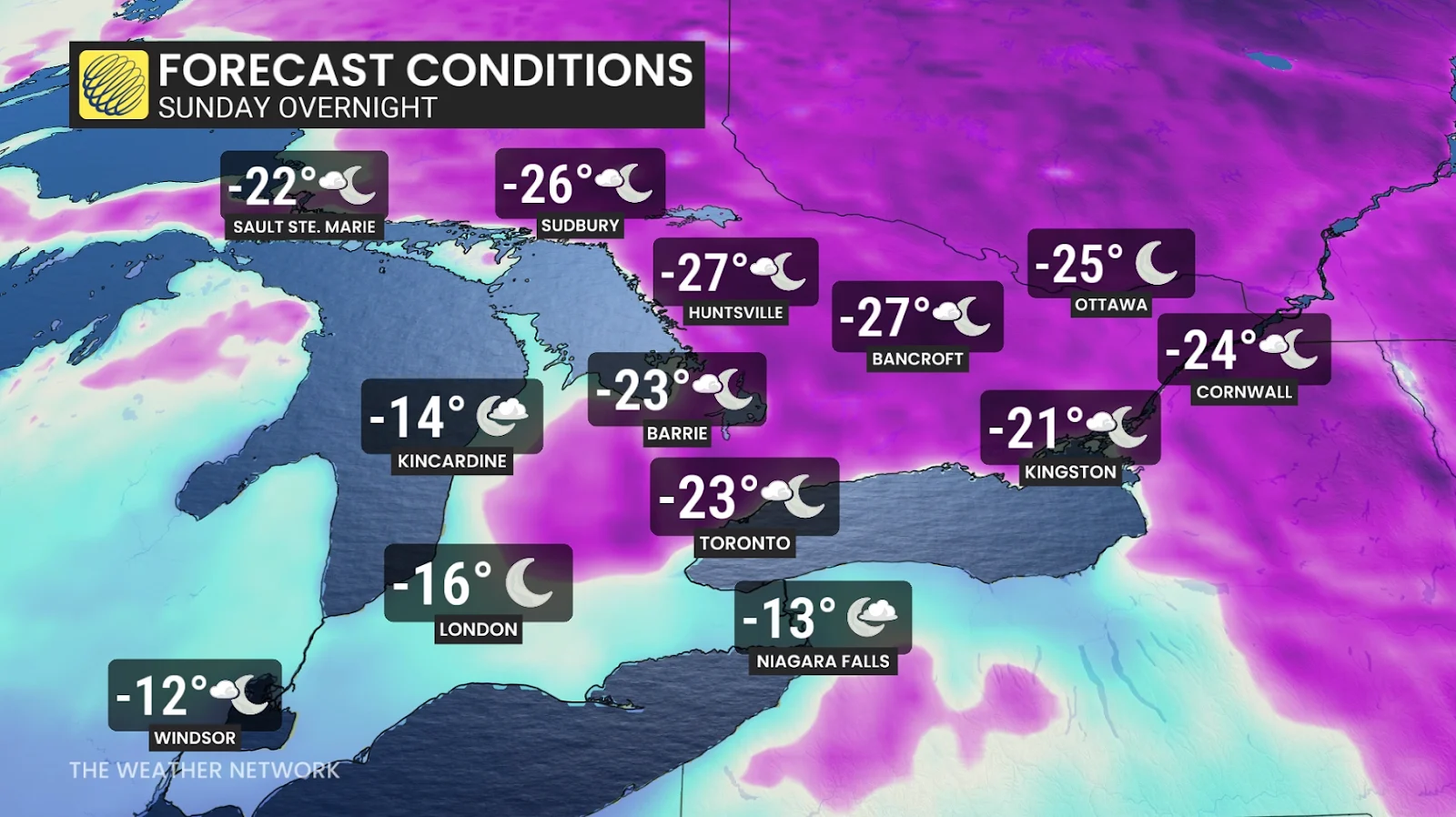
We’ll see readings continue to fall well below the freezing mark by Saturday evening, with temperatures getting even colder into Sunday.

Toronto will see temperatures drop from -6°C on Saturday evening to -18°C by Monday morning, making for the coldest March temperature here since 2015. Wind chill values will dip as low as -25.
If the cold temperatures happen to exceed forecast expectations and drop to -20°C, we could see this be the third time this century that a March temperature has reached the -20s in Toronto. The last time this happened was on March 6, 2007, when temperatures reached -22.1°C. This is a stark contrast to the extreme warmth more recently felt in March, such as on March 22, 2012, when temperatures in Toronto reached a stifling 26°C.
Ottawa and Montreal could reach -20°C overnight Sunday with wind chill values of -25 to -30. If temperatures drop further to -25°C in Ottawa, it would be the coldest March temperature recorded for the nation's capital since March 6, 2007.
Weekend activities, including skiing, will require extra layers and face coverings to protect from the very cold temperatures.
Snow arrives behind the Arctic front
A round of snow will sweep across southern Ontario beginning Saturday evening and into the overnight hours.

Most regions, including the Greater Toronto Area, will see less than 3 cm of snow. However, there is a possibility that a few localized areas could overachieve and see a few extra centimetres of snowfall.
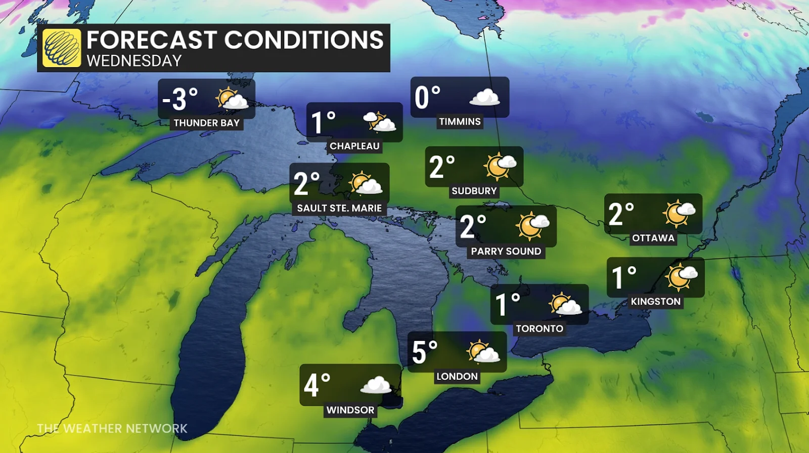
Temperatures recover next week, with a catch
Cold conditions will remain in place heading into the day Monday before we start to see temperatures rebound across the region.
Milder temperatures will attempt to nudge north into the middle of next week. A low-pressure system will likely accompany the warmth as an active storm track builds over southern Ontario.
Temperatures will be highly influenced by wind direction, however, and an east wind off of Lake Ontario could be all it takes to thwart any chances for significant March warmth.
A Colorado low looks to move through the region early Tuesday, bringing the opportunity for multiple types of precipitation.
Several factors will dictate what type of precipitation falls in each community, including the storm’s precise track and how warm temperatures are able to get. Regardless, folks should prepare for a messy system across the Greater Toronto Area that will bring wet snow, ice pellets, and localized accumulating snow. Forecasters will closely monitor this potential as the event draws closer.
Stay with The Weather Network for all the latest on conditions across Ontario.
Header image created using graphics and imagery from Canva.