Powerful Cascadia quake could trigger near-instant flood risk: report

A recent study found that a powerful quake off the Pacific Northwest could force the ground to sink up to 2 m, leading to major flooding within just a few minutes
A major West Coast earthquake along the Cascadia subduction zone could have an unexpected and destructive side-effect for shoreside communities throughout the region.
Research recently published in the Proceedings of the National Academy of Sciences (PNAS) outlines how a significant earthquake could lead to up to 2 metres of land subsidence along the Pacific Northwest coast—within minutes of the shaking.
Not only would land sinking to that extent lead to near-immediate flooding concerns for the affected communities, but it would translate to long-lasting environmental impacts.
DON’T MISS: Millions at risk as land sinks beneath major coastal cities, study finds
Powerful quake risk lurks just offshore
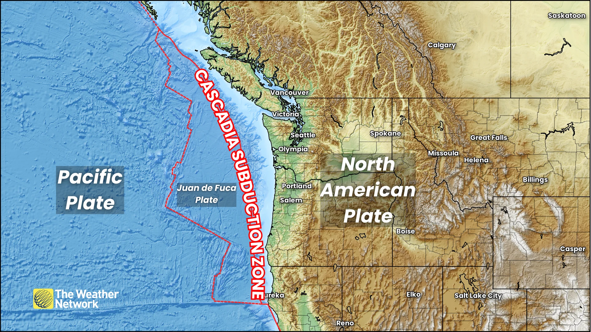
The Cascadia subduction zone is an offshore boundary that stretches from Vancouver Island to northern California, formed by the Juan de Fuca Plate subducting—pushing beneath—the North American Plate.
Subduction zones are prone to violent earthquakes. According to the study, experts estimate that there’s a 15 per cent chance of an 8.0 magnitude or greater quake along the Cascadia subduction zone within the next 50 years.
Major earthquakes are multi-faceted hazards, ranging from collapsed buildings to destructive tsunamis. But a major event can also lead to a large-scale sinking of the land known as land subsidence.
Land subsidence could cause flooding ‘within minutes’
Across communities near the Cascadia subduction zone, “the next great earthquake will likely cause 0.5 to 2 m of sudden subsidence and associated sea-level rise, dramatically expanding coastal floodplains,” the experts said in their paper published on April 28, 2025.
Many low-lying areas along the coast would face near-immediate inundation—wtihin minutes—following significant land subsidence after a major earthquake, their research found.
Similar instances of land subsidence on the order of 2 m or greater occurred after Chile’s magnitude 9.5 earthquake in May 1960, as well as the 9.2 quake that struck Alaska in March 1964.
MUST SEE: What is a tsunami? How these powerful waves spell coastal danger
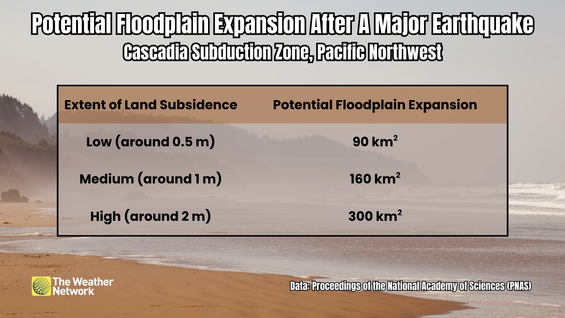
The researchers looked at 24 estuaries throughout the Pacific Northwest and calculated how much the floodplain might expand under different scenarios of quake-induced land subsidence.
Low subsidence, around 0.5 m, would expand the region’s floodplains by 90 square kilometres. High subsidence of about 2 m would lead to a 300 square kilometre increase in the floodplains—marking a huge risk for local residents and infrastructure. Sea-level rise from climate change would lead to even greater coastal inundation by the year 2100.
Significant effects beyond flooding
The threat for near-immediate flooding is a deadly hazard for coastal communities during a very strong earthquake. But excessive land subsidence would also have long-lasting effects on the local environment.
Loss of wetlands would disrupt or destroy marine habitats, the paper notes. Researchers added that subsidence would increase tidal range on estuaries—as much as 10 per cent on the Columbia River, for example.
None of this flooding risk takes into account the potential for tsunamis, which would add another deadly hazard on top of flooding caused by land subsidence.
The study pointed out that current tsunami hazard maps don’t take into account future sea-level rise; a relatively small earthquake could generate a tsunami with the equivalent height of a much larger quake by the end of this century due to rising sea levels.