Here's the latest on northwestern Ontario's forest fires: Wednesday, July 22

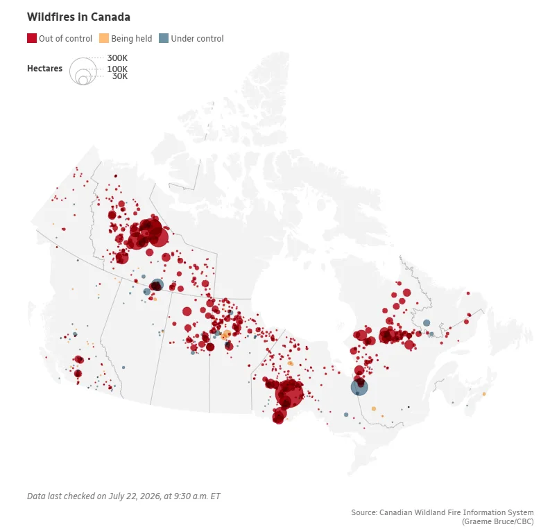
There were 146 active wildfires burning in northwestern Ontario as of Tuesday night, according to Ontario's Aviation, Forest Fire and Emergency Services.
Of these, 53 are listed as not under control, five are being held, seven are under control, and the rest are being observed.
Evacuation orders or alerts remain in effect for areas near the following fires:
The largest wildfire in the region, known as Thunder Bay 36, remains out of control, and spans more than 318,000 hectares.
"FireRanger crews, helicopters and heavy equipment operators are assigned to suppression efforts," Ontario's Aviation, Forest Fires and Emergency Services (AFFES) said in Tuesday evening's update.
"Recent precipitation over the last several days has helped to reduce fire behaviour, allowing for crews to make good progress on the fire line."
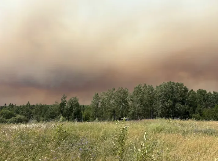
Wildfire smoke is seen in this photo taken between Thunder Bay, Ont., and Upsala July 13. (Sarah Law/CBC)
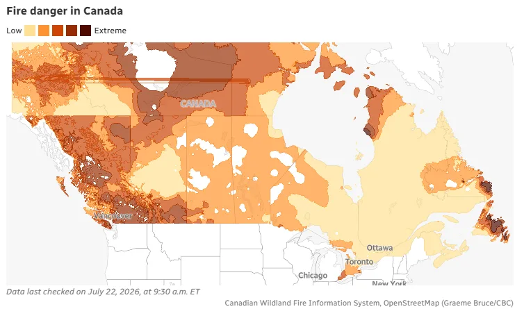
Forest fire danger ratings are mostly low across the northwest region — with areas of moderate hazard in the Kenora, Dryden and Fort Frances areas — except for a pocket of high hazard in the Sioux Lookout area.
"With cooler temperatures and cloud cover, fire activity on existing fires has remained minimal," Ontario Forest Fires said in a Facebook post on Tuesday.
"Although the fire hazard remains low across the northwest region, lightning associated with overnight precipitation still has the potential to cause new fire starts. The public is advised to exercise extreme caution, as holdover lightning fires may emerge in the coming days."
New fires in the northwest
There were 12 new fires confirmed in the region by Tuesday evening:
Fort Frances 45 (FOR045) is located on an island, on Bartley Lake. The 0.1-hectare fire is being observed.
Dryden 44 (DRY044) is located approximately 17 kilometers west of highway 599 and southeast of Press Lake. The 0.1-hectare fire is not under control.
Dryden 45 (DRY045) is located at the northeast end of Rice Lake. The 0.1-hectare fire is not under control.
Thunder Bay 61 (THU061) is located approximately 1.5 kilometers east of Wawang Lake and northwest of Little Harry Lake. The 0.1-hectare fire is not under control.
Nipigon 76 (NIP076) is located near Jobes Lake and approximately 27 kilometers southeast of Fort Hope. The 150-hectare fire is not under control.
Nipigon 77 (NIP077) and Nipigon 78 (NIP078) are located in the far north approximately 16 kilometers north of Webequie. Nipigon 77 is 70 hectares and is not under control, Nipigon 78 is 35 hectares and not under control.
Nipigon 79 (NIP079) is located in the far north approximately 81 kilometers northeast of Webequie. The 5-hectare fire is not under control.
Nipigon 80 (NIP080) and Nipigon 81 (NIP081) are located approximately 111 kilometers east of Webequie. Nipigon 80 is 10 hectares and is not under control, Nipigon 81 is 80 hectares and not under control.
Nipigon 82 (NIP082) is located approximately 12 kilometers northwest of Missisa Lake. The 8-hectare fire is not under control.
Sioux Lookout 103 (SLK103) is located on an island, on Wapesi Lake. The 0.1-hectare fire is not under control.
Highway closures in effect
According to the province's interactive highway map, the closure of Highway 527 at Kiashke Zaaging Anishinaabek — Gull Bay First Nation — has been extended to the Highway 811 junction.
Highway 811 is also closed due to ongoing wildfire activity, with the exception of local traffic evacuating the area.
The First Nation is now under a mandatory evacuation order after lightning brought the total number of wildfires surrounding the community to six, according to a release issued by the community early Tuesday morning.
In an update issued Monday evening, the Ontario Provincial Police (OPP) North West Region said:
"The OPP is currently assisting the MNR with an evacuation order of Gull Bay First Nation, which was previously under a self-evacuation. Individuals living in areas under mandatory evacuation orders have been asked to leave their residence immediately and seek safety away from active fires."
The police said other communities are being monitored and residents are urged to stay informed and be prepared to act quickly should further evacuation orders or advisories be issued.
"Additional information will be issued as it becomes available," the OPP said.
No new fires reported in the northeast
No new fires were reported in northeastern Ontario on Tuesday.
As of Tuesday night, there were 40 active wildfires in the northeast region. Of these, four are not under control, four are under control, and the rest are being observed.
Forest fire danger ratings are low across the northeast, with a pocket of moderate hazard in the North Bay area.
Location of evacuations
This year’s wildfire season has forced more than a dozen communities and areas to evacuate in recent days, including 11 First Nations.
As of Monday, roughly 2,415 people had evacuated to host communities across Ontario, including Thunder Bay, Kenora, Fort Frances, Lac Seul, Sioux Lookout, Red Lake, Barrie, Niagara Falls and Toronto.
A total of 312 air purifiers, 84 air filters and five air scrubbers have also been sent to several communities affected by wildfire smoke, according to the Ontario Corps.
As part of these efforts, Feed Ontario and the Ontario Federation of Indigenous Friendship Centres are shipping and distributing food to evacuees.
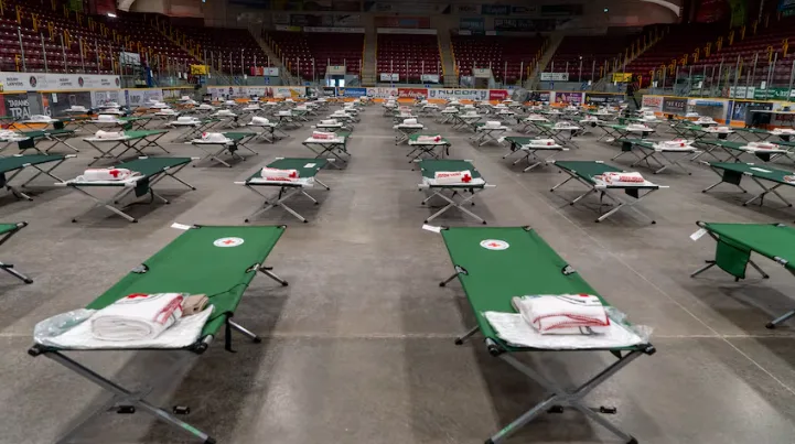
GlobalMedic has also delivered essential supplies to the reception centre at the Fort William Gardens Arena in Thunder Bay.
__ All city facilities and programs resume__
As of Tuesday, the Air Quality Health Index for Thunder Bay was at low-risk conditions throughout the day, but air quality is expected to worsen again with moderate risk tonight and into Wednesday.
The City of Thunder Bay has resumed normal operations of all facilities, outdoor programs, parks, beaches, pools and recreational amenities that were temporarily impacted by wildfire smoke.
City crews have also resumed regular outdoor work and will continue to monitor conditions.

Donations for wildfire evacuees are organized at Kiikenomaga Kikenjigewen Employment and Training Services' warehouse in Thunder Bay, Ont., on Tuesday. (Marc Doucette/CBC)
The city also said it remains prepared to support regional response efforts and additional evacuations should the need arise, and will continue to work closely with emergency management partners across the region.
WATCH: Doug Ford provides update on wildfire situation in northern Ontario
The story was originally written by Nicky Shaw and published for CBC News. With files from Liam Baker and Sarah Law.