A typical September sends Canada heat, frost, hurricanes, and snow

Fall begins to settle in across Canada as we progress through a normal September
The worst of summer is behind us as we head into the month of September.
Autumn’s arrival is a bumpy time of year across Canada, with stubborn warmth fending off frequent pulses of chilly air swooping in from the north.
From continued bouts of extreme heat to hints of frost and even some snow, here’s what you might expect across Canada during a typical September.
DON’T MISS: What does a classic fall storm look like in your part of Canada?

Cool-weather lovers spend all summer looking forward to this time of year. Meteorological fall arrives on Sept. 1, while the official autumnal equinox occurs on Monday, Sept. 22.
Dwindling sunshine and changing seasons will quickly begin to shift our weather patterns across Canada over the next month, most noticeably when it comes to temperature trends.
Temperatures quickly fall through September
Extreme heat is still possible across Canada during a normal month.

MUST SEE: When is the hottest stretch of the year in your corner of Canada?
The country’s all-time hottest September temperature record is a 40.0°C reading that most recently occurred in Lost River, Sask., back in 1940. Toronto made it up to 36.7°C on Sept. 2, 1953, while Halifax saw a 34.2°C high temperature on Sept. 1, 2010.
Those sweltering days are exceptions to the rule. Average temperatures from coast to coast quickly decline throughout the month, dipping into the teens for just about every major city, with normal readings sagging into the single digits across the territories.
Some parts of the country can see some mighty cold, as well. The month’s coldest reading was a -31.7°C temperature recorded at the Eureka Airport in Nunavut on Sept. 25, 1961.
First frosts arrive in September for many regions
Cooler weather sweeping across the country begins the inevitable countdown toward the season’s first frosts.

Many communities on the Prairies, the B.C. Interior, and the territories up north can expect their first frost during the month of September.
Regina, Saskatoon, and Calgary witness their average first frost during the third week of the month, while Winnipeg, Edmonton, and Kelowna register their inaugural frost toward the latter half of September.
Wet weather is common, snow makes an appearance
No major cities log their wettest or driest stretches of the year to kick off the fall season.
SEE ALSO: What’s the wettest month in your corner of Canada?
A normal month features a steady drumbeat of cold fronts, low-pressure systems, and the occasional tropical remnants that can all produce heavy rainfall from coast to coast.
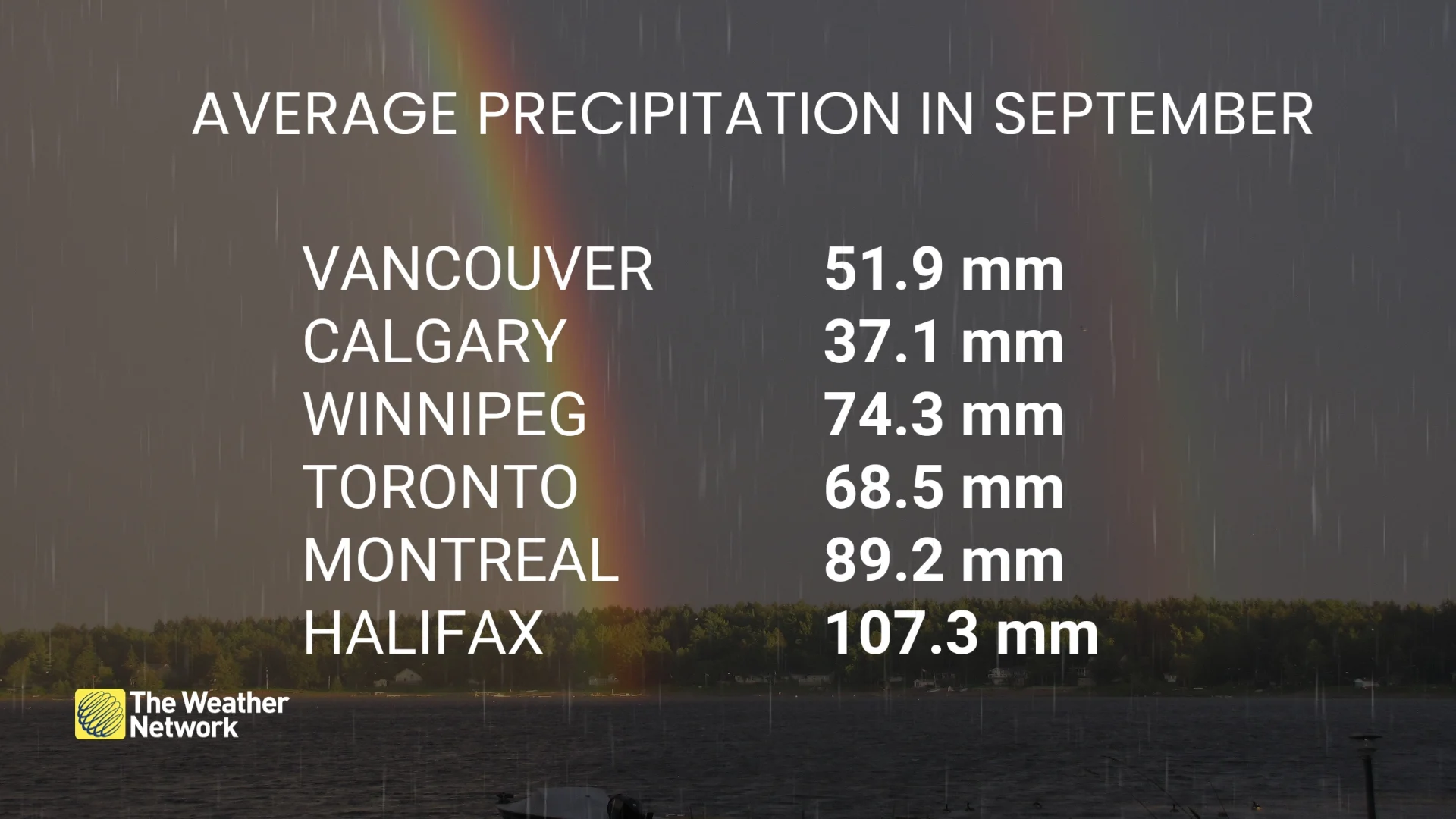
Average precipitation totals range from 37.9 mm in Calgary all the way up to 107.3 mm in Halifax. The month begins the West Coast’s steady climb from the dry summer season, with about 51.9 mm falling in Vancouver during your standard September weather.
We also have to begin thinking about snow.
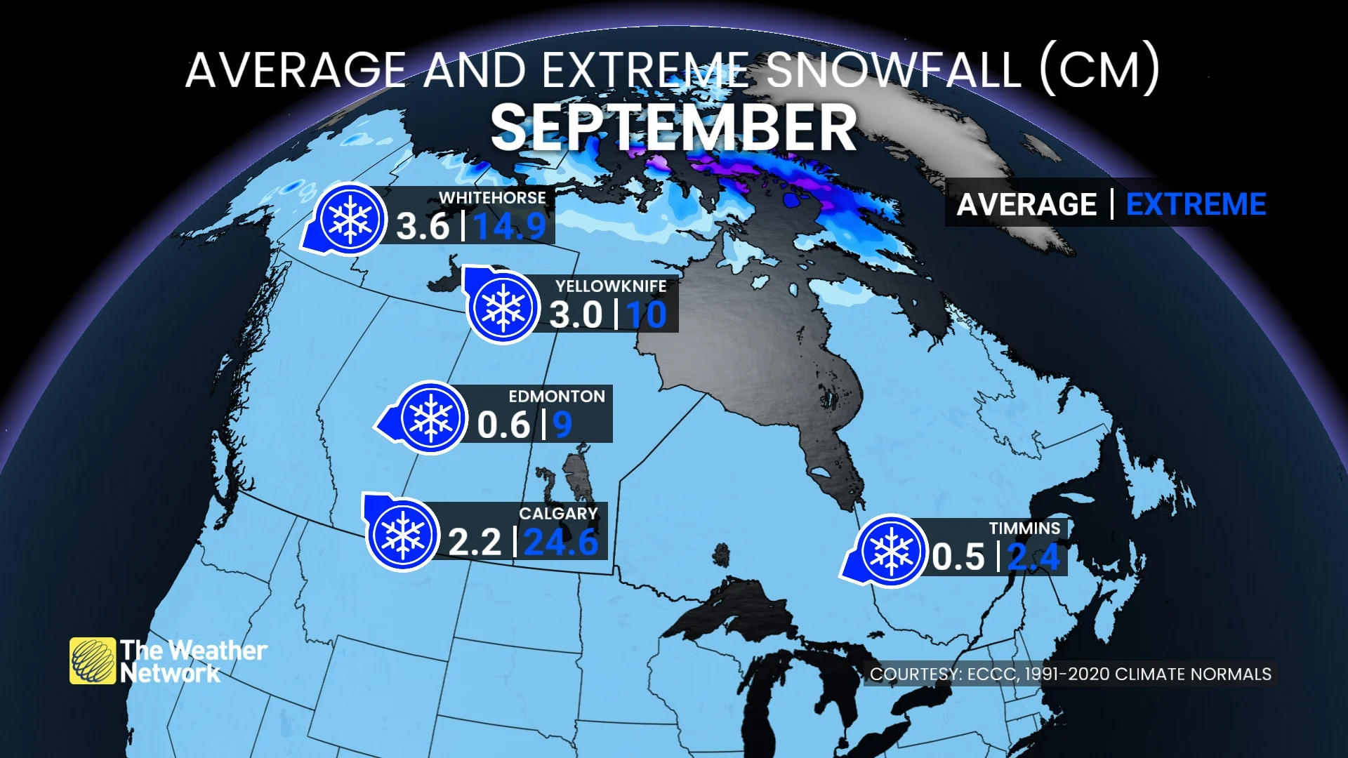
Conditions across Northern Canada and the Prairies are occasionally cold enough to support snowfall. While the majority of September’s snows are conversational in nature, every so often we’ll see a storm that lays down an early-season coating.
Whitehorse and Yellowknife typically pick up 3-4 cm of snow during a typical month. Timmins averages 0.5 cm of snow in a normal September.
Flakes can start flying on the Prairies, as well, where Calgary averages around 2.2 cm of snow. One storm back on Sept. 29, 2019, dropped a whopping 24.6 cm on Calgary—an impressive feat for so early in the season.
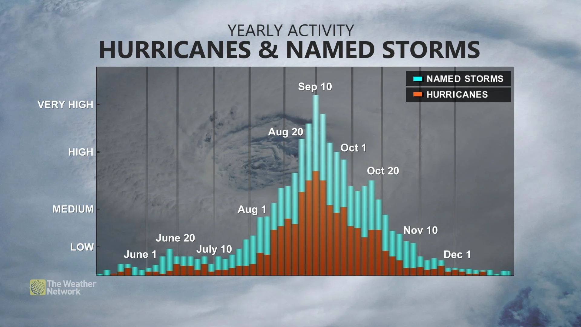
Hurricane season peaks in September
Hurricane season continues to heat up even as Canada’s weather cools down.
RELATED: Autumn can still produce intense hurricanes across the Atlantic
Historically, the season peaks during the second week of September, with tropical storms and hurricanes common throughout the month.
Some of the most impactful storms in Canadian history swept through Atlantic Canada in September, including Juan in the Maritimes in 2003, Igor in Newfoundland in 2010, Dorian in 2019, and Fiona in 2022.
Tropical hazards don’t stop at the coastline. Remnants of storms making landfall in the United States can continue north into Canada and bring high winds, flooding rains, and even tornadoes to Ontario, Quebec, and the Atlantic provinces.