Canada's 2025 Fall Forecast: An extended pause could redefine the season ahead

Will autumn end with a free fall into winter? Find out in The Weather Network's 2025 Fall Forecast.
The transition from summer to early fall has featured a dramatic contrast in temperatures across Canada. Autumnal weather has already made early appearances across central Canada, including record-breaking cold temperatures.
However, we have also seen record-shattering heat, especially in western Canada. Will the upcoming fall season continue to be a season of extremes? Please read on to find out what you can expect from the remainder of September, October, and November.
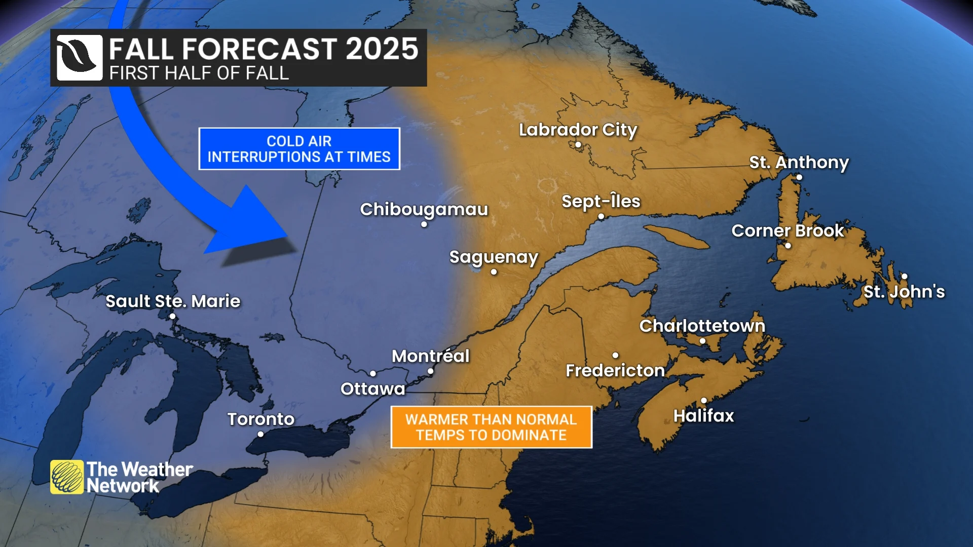
Fall is typically a turbulent and changeable season as we make the transition from summer to winter. However, during the heart of the fall season, from mid-September through October, we expect that this fall will feature an extended stretch of more consistent mild weather with fewer than the typical number of fall storms for most of Canada.
This should provide us with periods of pleasant weather for getting outside and enjoying Canada’s amazing fall foliage.
Here is a look at our national temperature forecast for the upcoming fall season, which features warmer than normal temperatures for most of the country.

SEE ALSO: Three reasons why you could see an early-fall snow in Canada
However, we do not expect that the relatively mild conditions will last all the way to the end of the season. During November we expect a return to a more active and changeable pattern, which is typical for late fall. For parts of Canada this will mean a rather abrupt transition into early winter.
Which part of Canada will be the first to see the pattern change to near-normal and possibly colder-than-normal temperatures during November?
We currently have conflicting signals, but we think that the western half of the country will be the first to see the drop-off into early winter, with mild temperatures persisting longer across eastern Canada. However, we expect that the mild pattern across eastern Canada will flip to a colder pattern before November is over.
National Precipitation Forecast
From mid-September through October, we expect that most of Canada will see fewer than the typical number of fall storms. However, there will be a couple of exceptions.
For the B.C. coast, we expect that the fall storm season will start close to on schedule during October with a few moisture-laden storms and a risk for excessive rain. An active pattern is also expected across parts of northern Canada, and of course this region will see a transition to ice and snow as we get deeper into the fall season.
Elsewhere across Canada we expect that a more typical fall pattern will develop for November, resulting in near-normal precipitation totals for the season. However, from northeastern Ontario to western Labrador, we have the potential for above-normal precipitation totals.
Here is a look at our national precipitation forecast for the rest of September, October, and November.

DON'T MISS: Ready or not, October snows can and will fall across Canada
Our greatest uncertainty in precipitation is across Atlantic Canada, where much of the region had an exceptionally dry summer. We expect fewer fall storms than normal, so this region could readily end up with below-normal precipitation. However, if the remnants of one or two tropical systems impact the region, then precipitation totals would end up being near normal.
Below is a more detailed look at what we expect across Canada this fall:
British Columbia
Warm and dry conditions are expected to continue through the end of September. While that may sound like great news for many outdoor activities, unfortunately that also means that wildfire smoke and the risk for more fires will continue to be a concern deeper into the fall season than we typically see.
However, the heat will fade as we progress through September, and as we get deeper into fall, we expect that temperatures will trend back to near seasonal for much of October and November.

The rainy season is expected to start roughly on schedule during October with a typical number of fall storms for the south coast region, including Vancouver and Victoria. However, due to much warmer than normal water temperatures in the North Pacific, we expect that precipitation totals will be above normal, and we are concerned about the risk for excessive rain at times.
With near-seasonal temperatures expected during late fall, along with an active pattern at times, we expect that the ski season will be able to start close to on schedule.
WATCH BELOW: B.C.'s 2025 Fall Forecast
Alberta
Warmer than normal temperatures are expected to dominate through October across the province, including Edmonton and Calgary. Of course, there will be some interruptions with shots of colder weather—fall in Alberta is notorious for wild temperature swings. But the heart of the season should feature extended periods of pleasant weather.
This will provide periods of pleasant conditions for a variety of outdoor activities, from wrapping up the fall harvest to exploring the provincial and national parks.
However, we expect a flip in the pattern late in the season with a much colder and more active pattern developing for November.
Precipitation totals for the season are expected to be near normal for most of the province, but southern and western areas could see above-normal totals.
A strong start to winter is expected across the region. So, be sure to savour the mild weather while it lasts.
WATCH BELOW: 2025 Fall Forecast for Alberta, Saskatchewan and Manitoba
Saskatchewan and Manitoba
We have already seen a couple shots of rather chilly weather, but the heart of the fall season, from mid-September through October, is forecast to feature periods of pleasant weather for concluding the harvest and a variety of other outdoor activities. Of course, there will be some interruptions with shots of cooler weather at times, but overall warmer-than-normal temperatures are forecast to dominate across the region, including Saskatoon, Regina, and Winnipeg.
However, we expect a flip in the pattern late in the season with a much colder and more active pattern forecast to develop for November. This could mean a more abrupt transition to early winter across the region. So, be sure to savour the mild weather while it lasts.

Near-normal precipitation totals are expected, but parts of Manitoba could tip to the dry side of normal. And long before we get to the end of the season, some of that precipitation will fall as snow and ice. A strong start to winter is expected across the region.
Ontario
The end of August and early September delivered a rather abrupt transition from summer heat to much cooler autumnal weather. However, for the heart of the fall season, from mid-September through October, warmer-than-normal temperatures are forecast to dominate across the province, including London, Toronto, and Ottawa.
In addition to the mild temperatures, we expect more sunshine and fewer than the typical number of fall storms through October. That should provide periods of pleasant weather for enjoying the fall foliage.
However, a more active pattern is expected to develop during November. Mild temperatures are expected to persist into November, but we are closely watching the potential for a more abrupt transition into early winter. This should allow ski areas to start their season close to on schedule.
WATCH BELOW: Ontario's 2025 Fall Forecast
Quebec
Autumnal weather has already made a few early appearances during late August and early September, giving us a rather quick transition from summer heat to much cooler conditions at times.
However, as we look ahead to the heart of the fall season, from mid-September through October, warmer-than-normal temperatures are expected to dominate across the province, including Montreal and Quebec City.
In addition to the mild temperatures, we expect fewer than the typical number of fall storms through October. That should provide periods of pleasant weather for enjoying the fall foliage with more sunshine and fewer rainy days than normal.

However, a more active pattern is expected to unfold during November. Mild temperatures should persist well into November, but we are closely watching the potential for a more abrupt transition into early winter. This should allow ski areas to start their season close to on schedule.
WATCH BELOW: Quebec's 2025 Fall Forecast
New Brunswick, P.E.I. and Nova Scotia
Fall is often a tumultuous and changeable season, but this year we expect a milder season, especially through October. While there will be some chilly interruptions, above-normal temperatures are forecast to dominate, with fewer than the typical number of fall storms across the region, including Halifax, Charlottetown, and Fredericton.
As we approach the end of the season, we expect a transition to a more typical late fall pattern, and temperatures should be near seasonal as we make the transition into early winter.
After an exceptionally dry summer, the risk for wildfires and dry conditions will continue to be a concern through early fall, but we will see some improvement as we get deeper into the season. While most of the season should be drier than normal, a couple of low-pressure systems could tap into subtropical moisture (possibly the remnants of a tropical system), and this should bring precipitation totals close to normal.
WATCH BELOW: Atlantic Canada's 2025 Fall Forecast
Newfoundland & Labrador
Fall is typically a changeable and stormy season, but this year we expect a milder season compared to normal. Of course there will be some chilly interruptions, but above-normal temperatures are expected to dominate with fewer fall storms than we typically see across the province, including St. John’s and Corner Brook. However, as we approach the end of the season, we expect a transition to a more typical late fall pattern.
While fewer than normal fall storms are expected, a couple of low-pressure systems could tap into subtropical moisture (possibly the remnants of a tropical system), and this should bring precipitation totals close to normal.
Northern Canada
Above-normal temperatures are forecast to dominate across most of the region, including Yellowknife and Iqaluit, especially during the first half of the season, as we make the inevitable transition from summer to winter across the region. Southwestern parts of the Yukon territory, including Whitehorse, are expected to be near seasonal or slightly warmer than seasonal.
Smoke and wildfire concerns are lingering later into the fall season than we typically see. However, the end is in sight as seasonal temperatures are quickly falling now, and a more active pattern is expected to develop with near-normal or above-normal precipitation totals expected across the region. Of course, that will soon mean substantial snow and ice as we get deeper into the season.
WATCH BELOW: Warmth dominates most of the season across Northern Canada
While most of Canada will see an extended period of mild temperatures during the fall season, keep in mind that “seasonal” temperature will continue to rapidly fall through the season as we make the inevitable transition from summer to winter over the next few weeks.
What can we expect from the upcoming winter season? Please check back in early October for a sneak peek at what a developing weak La Niña and an exceptionally warm north Pacific could mean for the winter of 2025-2026. Our official 2025-26 Winter Forecast will be released on November 26th.
