Summer 2026: El Niño may make Canada’s summer simmer instead of sizzle


All eyes are on a strengthening El Niño as Canada progresses through summer. Here's what you can expect for the heart of the summer season.
Welcome to The Weather Network's official Summer Forecast of 2026.
The sneak peek was all about the setup: the drivers, the mechanics, and the atmospheric forces beginning to shape the season ahead.
Now that summer is officially underway, the forecast is already showing its personality: heat in British Columbia, heavy-rain interruptions across parts of the Prairies, Ontario, and Quebec, and a lack of extreme heat.
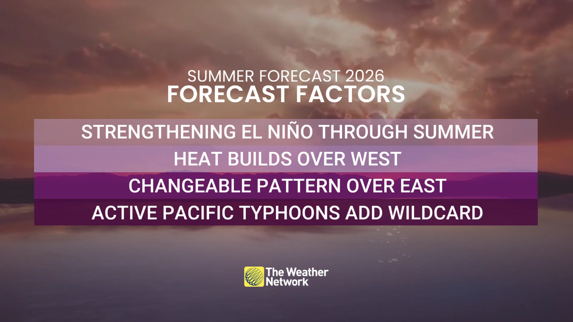
Recent summers have trained many Canadians to expect smoke, drought concerns, and stubborn high-pressure ridges. This year looks different, with a more changeable pattern expected across much of the country.
Summer isn’t cancelled, Canada, but for much of Eastern Canada, it may struggle to lock into place. For many Canadians, this can still be a pleasant summer, just not one that locks into relentless heat for weeks at a time. Farther west, summer has already established itself across B.C., while the Prairies have seen a more uneven start marked by stormy interruptions and locally heavy rainfall. As we move into July and August, however, the broader western pattern is still expected to lean more consistently summer-like, but this does not look like a season dominated by one relentless ridge from start to finish.
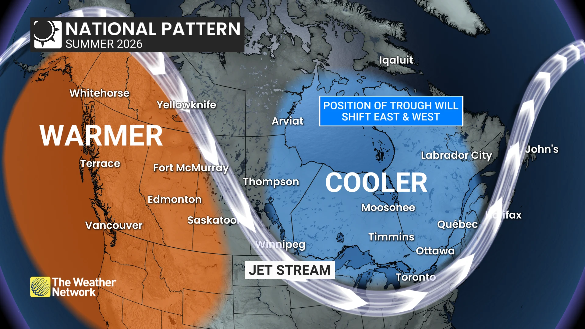
That could mean fewer prolonged extremes, more interruptions, and a season defined less by relentless heat and more by fluctuation. The historical comparisons do not point to a summer without heat, but rather they point to a summer where heat struggles to lock in for long across much of Eastern Canada.
As summer begins, June has already carried traces of spring DNA across parts of the country, especially from southern Ontario through Quebec and Atlantic Canada. Newfoundland has remained persistently below seasonal, while much of the country has avoided significant extreme heat.
Below is a more detailed look at what we can expect across the country, including the factors that will come into play in addition to El Niño. We've also included an FAQ section that may answer some of your questions now that summer is officially underway.
British Columbia
Summer personality: Warm, confident, but not reckless
Fast start, earlier fade?
Summer has started strongly in B.C., including coastal heat, reinforcing the province’s position within the country’s strongest early warmth signal
Transient heat waves remain likely, though this does not appear to be a prolonged ‘heat dome’ summer
Periodic pattern breakdowns should provide some relief
B.C. sits within the country’s strongest warmth signal
But unlike recent years, summer may fade earlier heading into September
Alberta
Summer personality: Warm, but watchful
Strong start, moisture concerns
Alberta also sits within the stronger warmth signal, especially early in the season
Periods of significant heat are likely, but timely pattern breaks could help prevent drought from escalating
June moisture was key, and too much of it fell all at once. Recent heavy rainfall has helped in some areas, but the balance between timely rain and prolonged dry stretches will determine whether drought concerns return later this summer.
SEE ALSO: When is the hottest stretch of the year in your corner of Canada?
Saskatchewan, Manitoba, and Northern Ontario
Summer personality: Changeable and reactive
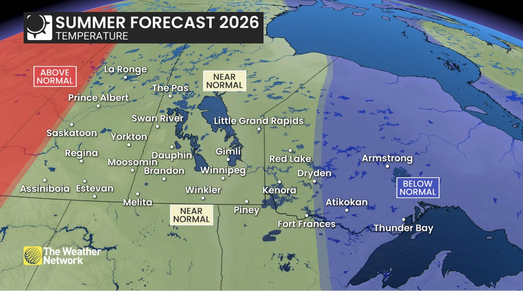
A tug-of-war
The start of summer has been uneven, with early warmth competing against stormy interruptions and locally heavy rainfall
Periods of heat are expected, but interruptions should help limit widespread drought escalation
Warmth is more likely to dominate in the West, while the cooler signal is stronger farther east
June rainfall was critical across the Prairies, but the opening weeks of summer have already shown the other side of the equation: heavy, training thunderstorms can quickly turn beneficial moisture into flooding concerns
The pattern may lock in briefly before shifting again

RELATED: Latest forecast warns a very strong El Niño could emerge soon
Southern Ontario
Summer personality: Noncommittal and inconsistent
The on-again, off-again summer
Heat will build at times, but interruptions are expected throughout the season
Final temperatures may finish surprisingly close to the seasonal mark overall
The unsettled signal has already shown itself, with heavy rainfall at times across Ontario throughout June. More shower and thunderstorm days remain likely, though that does not mean a washout summer
Cooler-than-normal Great Lakes may create early-summer shoreline chills
One hot weekend won’t necessarily mean summer weather is here to stay
DON'T MISS: How lake breezes shape your weather
Quebec
Summer personality: Changeable
The back-and-forth summer
A changeable summer is anticipated, with very warm stretches at times, but enough cooler interruptions to keep final temperatures close to seasonal
Western and southern Quebec may tip slightly below seasonal, while eastern Quebec has a better chance to finish near seasonal
Quebec has already seen the active side of the pattern, with heavy rain at times. Showers and thunderstorms should remain more frequent than usual, but that does not mean a washout summer
Wildfire and air quality risk appear lower than recent summers, though any hot and dry stretch could spike the fire danger
The Maritimes (Nova Scotia, New Brunswick, and P.E.I.)
Summer personality: Quietly pleasant
Sneaky summer potential
Near-seasonal temperatures are expected overall
Atlantic Canada could see stretches of solid summer warmth if the trough pulls farther west toward the Great Lakes or Prairies
Less persistent dryness than recent summers is expected
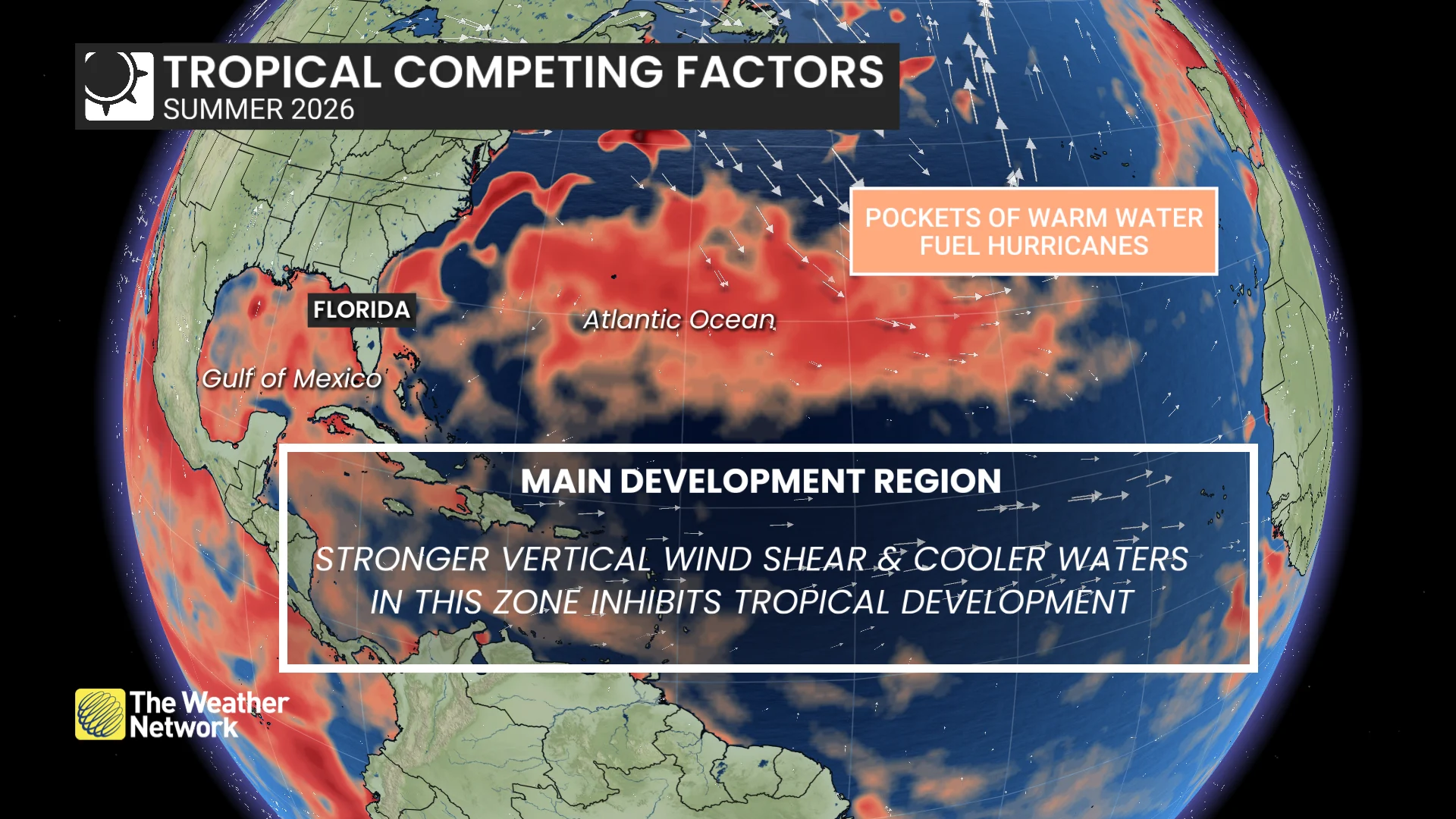
Hurricane activity will likely be quieter overall, but impactful storms remain possible
Newfoundland and Labrador
Summer personality: Sluggish start, steady finish
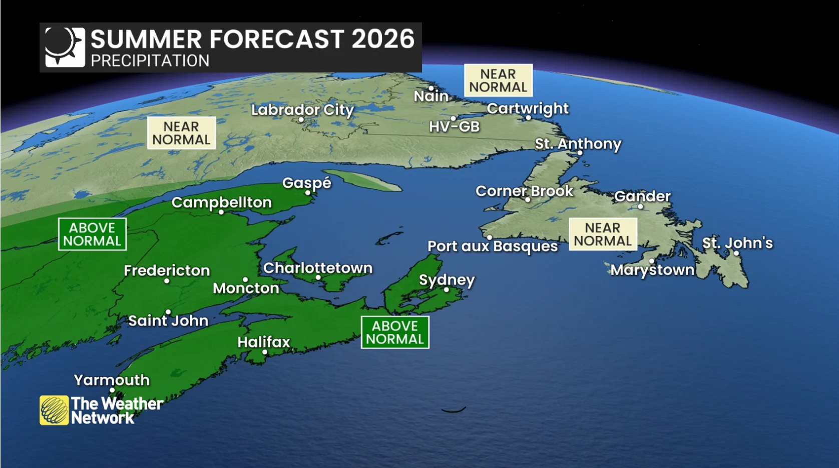
The late-blooming summer
A near-seasonal summer is expected, with temperatures and precipitation likely finishing close to normal
June has started slower than many Newfoundlanders would like, with significantly below-seasonal stretches delaying the true summer feel
A less active Atlantic hurricane season is expected, but Newfoundland should not let its guard down, as it only takes one post-tropical system or a close approach to create major impacts

Northern Canada
Summer personality: Moody and contrasting
Contrasting extremes
Western portions of the territories are expected to trend warmer than normal, raising drought, wildfire, and smoke concerns in Yukon and the Northwest Territories
Farther east, Nunavut could trend cooler than seasonal overall
Smoke concerns may fluctuate depending on fire activity
THE BATTLE FOR SUMMER
Key message: El Niño isn’t acting alone this time
El Niño: less pattern locking
Stronger jet stream
Atlantic warmth
Bermuda high
Recurving typhoons
Trough position
Soil moisture/drought conditions
Key message: The trough may decide Canada’s summer. The challenge is that it will be a moving target: oscillating, stretching, and occasionally anchoring in place
A faster west-to-east flow lowers the odds of long-lasting, continent-wide extremes, but cut-off highs and lows can still detach from the main jet stream and create impactful stretches of heat, rain, or storms.
We forecast the season and try to anticipate the broad patterns and themes, not the individual weekends and specific weather patterns ahead. We know one bad long weekend can reshape the reputation of an entire summer.
THE BIG SUMMER QUESTIONS
Q: Will summer really lock in this year?
A: Blocking patterns are what typically create prolonged heat, drought, and persistent extremes. With El Niño, you get fewer of these patterns, a stronger jet and more west-to-east progression, favouring more simmer than full-on nationwide sizzle.
Q: Why doesn’t this summer look like recent summers?
A: This summer doesn’t appear to have the fingerprints of a coast-to-coast, locked-in heat dome year. A developing El Niño typically supports a stronger jet stream and more movement in the atmosphere, reducing the risk of prolonged extreme heat events.
Q: Is June still going to feel like spring?
A: In some parts of Canada, yes, and that has already been the case. June has carried traces of spring DNA this year, especially across Southern Ontario through Quebec and Atlantic Canada, where cooler interruptions and unsettled weather may show up more frequently. Portions of Northern Canada and Coastal B.C. have experienced above-normal temperatures this June.
Q: Could this summer feel cooler than the maps suggest?
A: Yes, and part of that comes down to psychology. Seasonal averages don’t fully capture how people emotionally experience summer weather. That has already been part of the story in places where heavy rain, clouds, and cooler interruptions have muted the summer feel despite the calendar flipping to late June.
We tend to remember standout events: the washed-out BBQ, the chilly cottage weekend, or the rainy long weekend. A few poorly timed cooler stretches can quickly tarnish the reputation of an entire summer. The reverse is also true: a perfectly timed vacation or several sunny weekends can make a summer feel much better than the map highlights.
Cooler-than-normal Great Lakes water temperatures may also create some early-season shoreline chills.
Q: Will Canada see a relentless heat dome summer?
A: A coast-to-coast heat dome pattern does not appear to be the dominant signal this year. A developing El Niño typically supports more west-to-east movement, which makes long-lasting extreme warmth less likely. That said, heat-dome-like setups cannot be ruled out. El Niño can also support split flow, which allows cut-off highs to become trapped outside the main jet stream. That means periods of significant heat are still possible, especially in the west.
Q: Will wildfire smoke become a major issue again this summer?
A: Wildfire smoke can always be a risk during the Canadian summer, but conditions heading into this season are generally less concerning than they were entering the previous few summers. For central and eastern Canada, air quality may improve compared to the past several years. British Columbia and northern Canada remain the key regions to watch for wildfire and smoke risk during hotter, drier stretches.
Q: Why are meteorologists watching the western Pacific typhoon season for clues about Canada’s summer?
A: If western Pacific typhoons recurve, they can inject energy into the jet stream and send ripple effects downstream across North America. At times, that energy can reinforce western ridging and deepen troughing farther east, including around the Great Lakes.
Q: Could this still become a historic summer weather-wise?
A: It’s possible. Seasonal forecasting focuses on broad patterns and tendencies, not individual severe thunderstorms or hurricanes.
Even quieter or cooler El Niño summers can still produce historic weather events and reshape how a season is remembered. The eerily quiet 1992 Atlantic hurricane season still produced Hurricane Andrew, one of the most destructive and costliest hurricanes in U.S. history.
And, during the cooler summer of 2009, Ontario experienced the largest single-day tornado outbreak in Canadian history with 19 confirmed tornadoes. Lower overall risk never means zero risk.
This article was written with the guidance and forecasting of Dr. Doug Gillham, a senior meteorologist at The Weather Network.