A typical April’s weather across Canada is one wild ride

April might be the most volatile month of the year across Canada
April is the middle of meteorological spring…on paper, anyway.
Perhaps more than any other month, April is a fickle time of extremes across Canada as winter’s stubborn chill holds strong against steady advances of springtime warmth from the south.
Whether it’s lingering snowstorms or severe thunderstorms, the month can feature just about everything in rapid succession. Here’s a glimpse at what a typical April looks like in your corner of the country.
DON’T MISS: What does a ‘normal’ spring look like across Canada?
Winter loosens its grip, but snow and ice remain common
April’s reputation as a gorgeous, spring-like month almost never lives up to its ideal in Canada. Even as folks south of the border bask in comfortable temperatures and witness the rebirth of plants and animals alike, a normal April in Canada is a tumultuous—and frequently chilly—time of year.
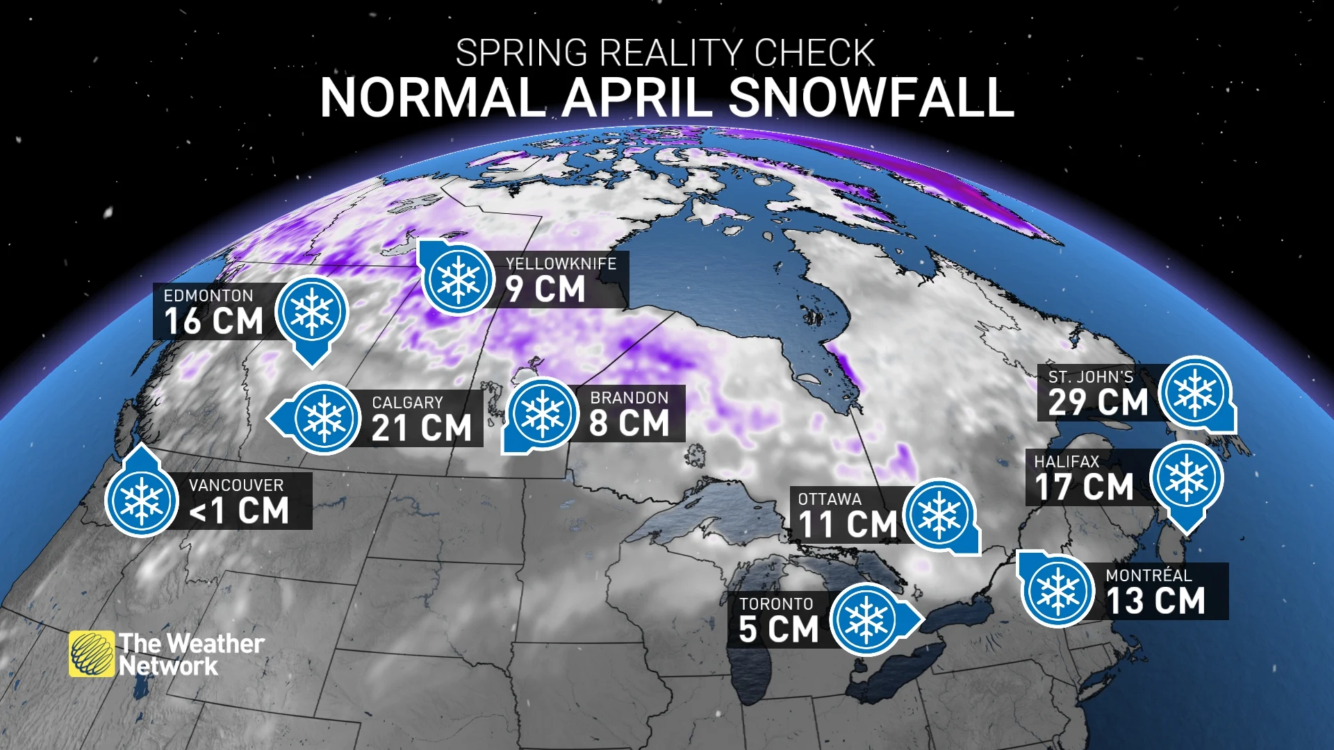
While it’s exceptionally rare for any major populated area of Canada to notch its snowiest month of the year in April, snow and ice remain common across the country throughout the month.
DON'T MISS: Get to know the hidden gems across Canada
The bulk of April’s snows are common on the western Prairies, where low-pressure systems can tap into tropical moisture from the south to produce bigtime snowfall events.
Calgary averages about 21 cm of snow during a normal month. In fact, April 26, 2003, brought Calgary its biggest-ever snowstorm when 32.2 cm of snow fell on the city.
RELATED: How the tropics help produce big springtime snows on the Prairies
Snowfall events are less productive and less common for much of the eastern half of the country once April arrives, with Toronto averaging about 5 cm of snow and folks in Ottawa and Montreal typically picking up 10-15 cm throughout the month. However, double-digit totals are still possible toward Halifax and St. John’s as coastal storms interact with cold air flowing in from the north and west.
Heavy rain begins to replace heavy snow as April rolls around. Communities across the country have to start to consider flooding concerns as heavy rain, snowmelt, frozen soil, and ice jams combine to clog waterways and create excess runoff.
Changeable temperatures, but averages rise in a hurry
Active storm tracks and bursts of winter’s waning chill often lead to wild temperature swings during a typical April. It’s not uncommon to need both a heavy coat and a short-sleeve shirt in the span of 24 hours.
Normal temperatures rise about 5-10 degrees for most communities across Canada between the beginning and the end of April. This steady rise in average readings helps make those below-seasonal days more tolerable than they would be in the heart of winter.
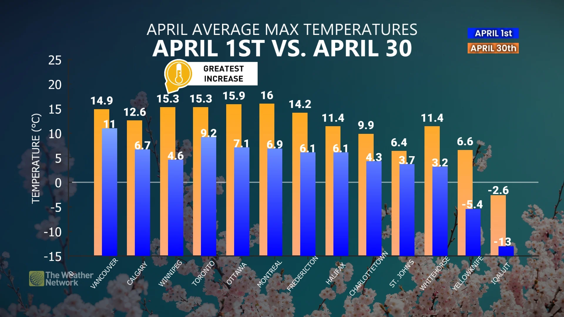
It’s not uncommon to see temperatures well into the 20s—especially later in the month—as low-pressure systems drag comfortable air north of the border.
On the bright side, at least the days are growing longer!
Despite all the wild weather we can encounter, at least the steady increase in sunlight is one constant we can appreciate during the middle of springtime.
Most cities across the country are on track to add 80 to 120 minutes of daylight between April 1 and April 30. Toronto starts the month with 12 hours and 46 minutes of sunshine, which will increase to 14 hours and 8 minutes of daylight by the final day of the month.
Winnipeg is on track to tack on 1 hour and 13 minutes of daylight through April, while sunlight increases by 1 hour and 11 minutes over in Vancouver.