Weather whiplash: Southern Ontario sees snow, wild winds, warmth and cooldown
It will be a tale of two seasons for southern Ontario early this week. A shot of wintry, windy weather will occur before a brief warm-up, which will be quickly followed by a dramatic temperature drop on Tuesday--bringing the potential for lake-effect snow.
As northern Ontario prepares for a major, disruptive winter storm, with 50+ cm of snow possible, southern areas will see some impacts from the the expansive low and won't escape entirely unscathed.
Unique hazards are possible with the powerful low targeting the Great Lakes through Monday. They include rapid temperature drops, strong-to-damaging winds and localized, heavy snowfall.
DON'T MISS: A potentially strong El Niño will develop by this summer
There will likely be travel impacts, and possible power outages.
Be sure to keep an eye on the road conditions before heading out Sunday and Monday, and again on Tuesday if you live in the snowbelts.
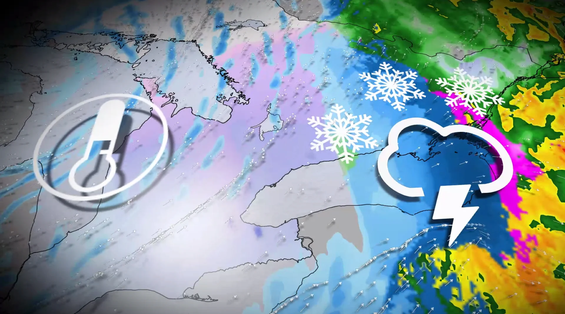
Sunday: Blustery, wintry weather could impact travel and power
The dynamic weather pattern shaping up for southern Ontario will bring some snow, intense wind gusts, rain and even a chance of thunderstorms early this week.
The warm front crosses southern Ontario on Sunday, giving bursts of snowfall across the region. 5-8 cm of snowfall is expected across cottage country.
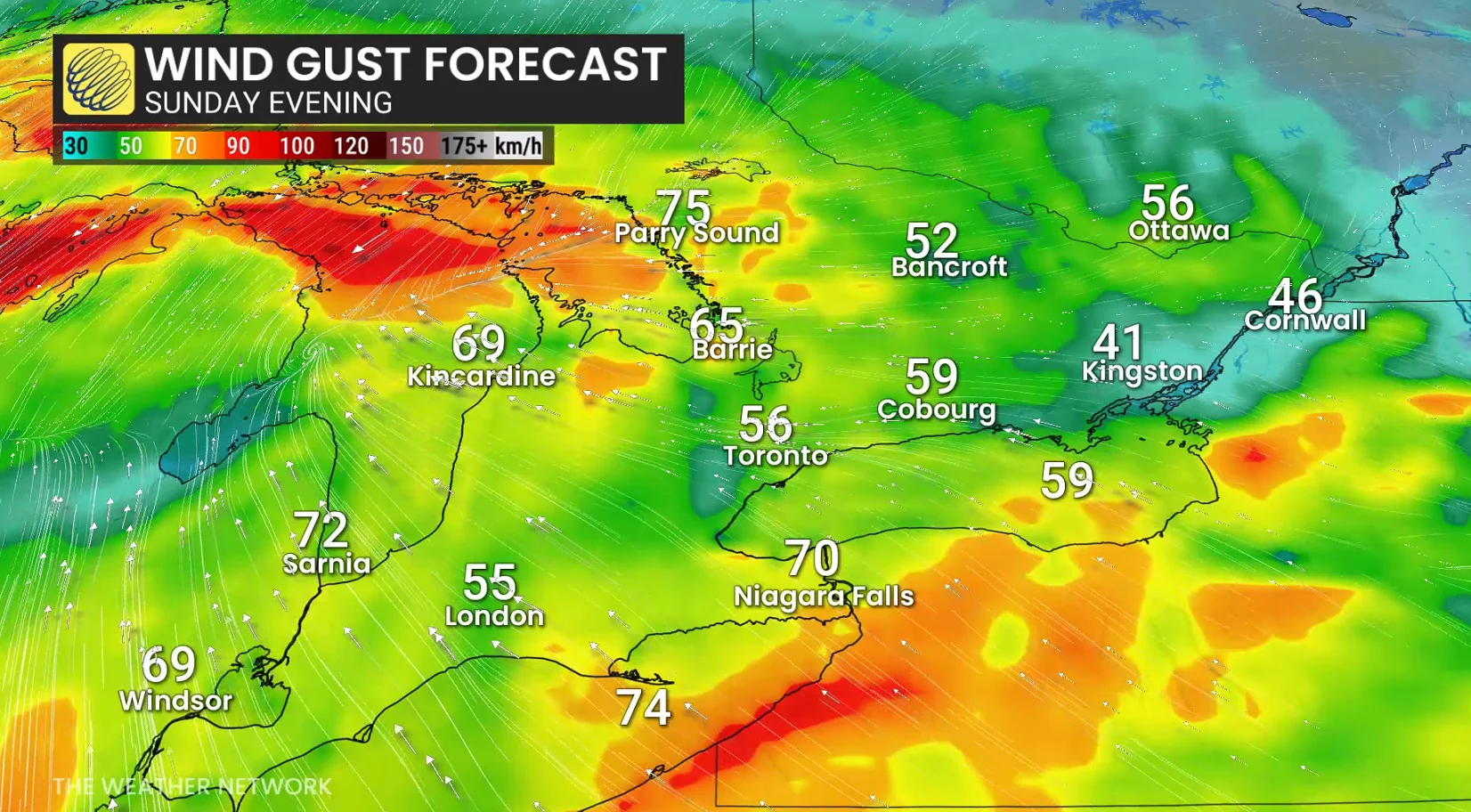
Wind gusts of 60-70 km/h across most regions as strong, easterly winds develop.
On Sunday night, the low approaches Lake Huron, increasing the threat of strong-to-damaging winds. Peak wind gusts: 80-100 km/h along the Huron shores across southern Ontario.
Strongest wind gusts remain above the escarpment and across the Niagara Peninsula.
Monday: From warmth, rain and thunderstorms to blustery winds, cooldown and snow
Heavy showers and mild temperatures are forecast for Monday in southern Ontario, with temperatures climbing into the low, double digits.
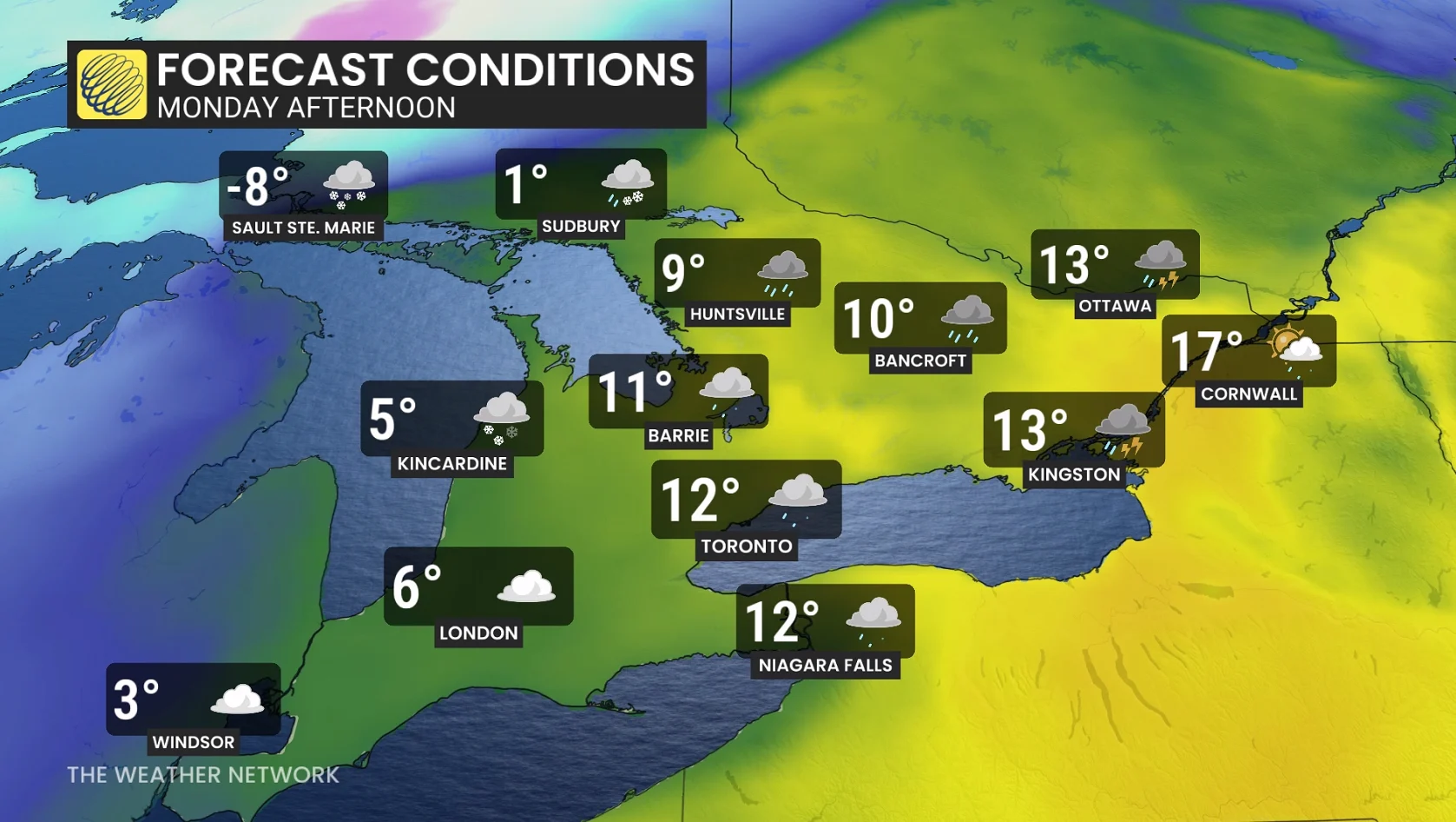
Widespread, double-digit temperatures are forecast by Monday afternoon in the south, with even temperatures briefly pushing closer to the 20-degree mark in extreme eastern Ontario.
A quick switch to wet snow is expected after mild temperatures in eastern Ontario, producing slick conditions late Monday into early Tuesday. Temperature drops of near 20°C to 25°C are possible in 12 hours for Ottawa, Brockville, and Cornwall.
Those regions are forecast to fall to freezing before midnight, increasing the risk for a local burst of heavy snow.
Very gusty, southwesterly winds build through Monday, producing gusts of 60-80 km/h. They will be strongest along the Lake Ontario and Lake Erie shorelines.
Damaging, west-northwesterly winds are forecast along the Lake Huron shore and Georgian Bay shores as the low lifts north, reaching as high as 90 km/h for those regions, and the north shore of Lake Ontario through Monday night and early Tuesday.

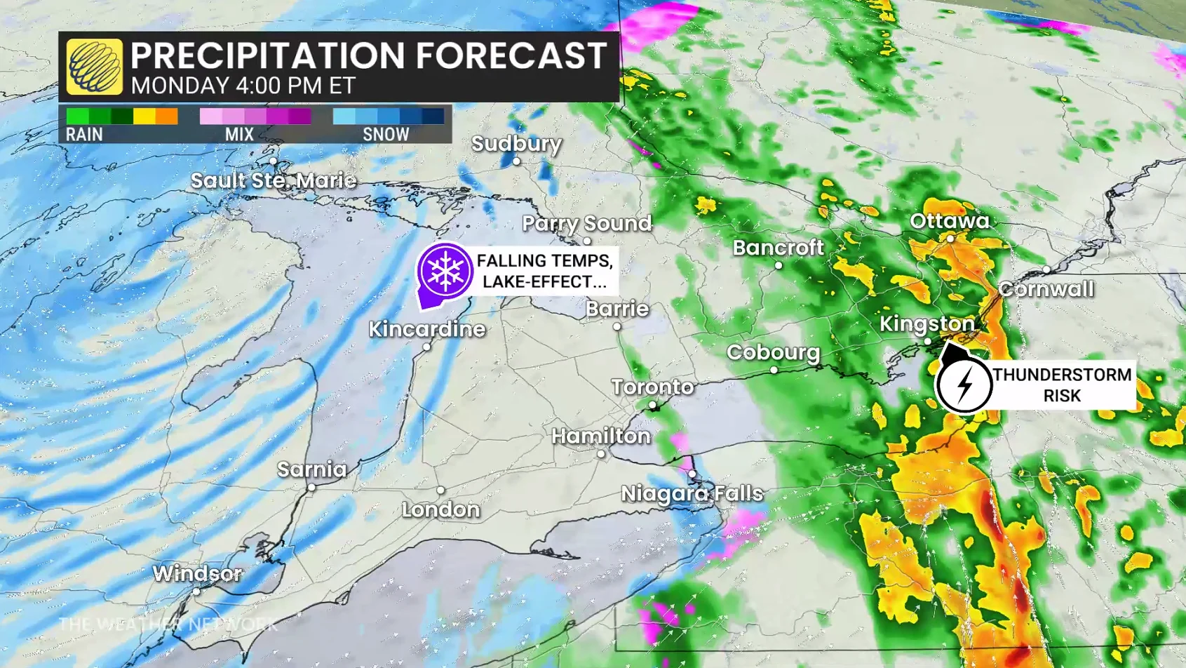
Early Monday may also feature sporadic rumbles of thunder across southern Ontario, but a more organized thunderstorm threat is looming in extreme eastern Ontario, east of Kingston. Strong winds, heavy rainfall and small hail are the primary threats.
On Monday night, rapidly falling temperatures will occur, making untreated surfaces and lingering puddle freeze--creating slick surfaces and slipping hazards.
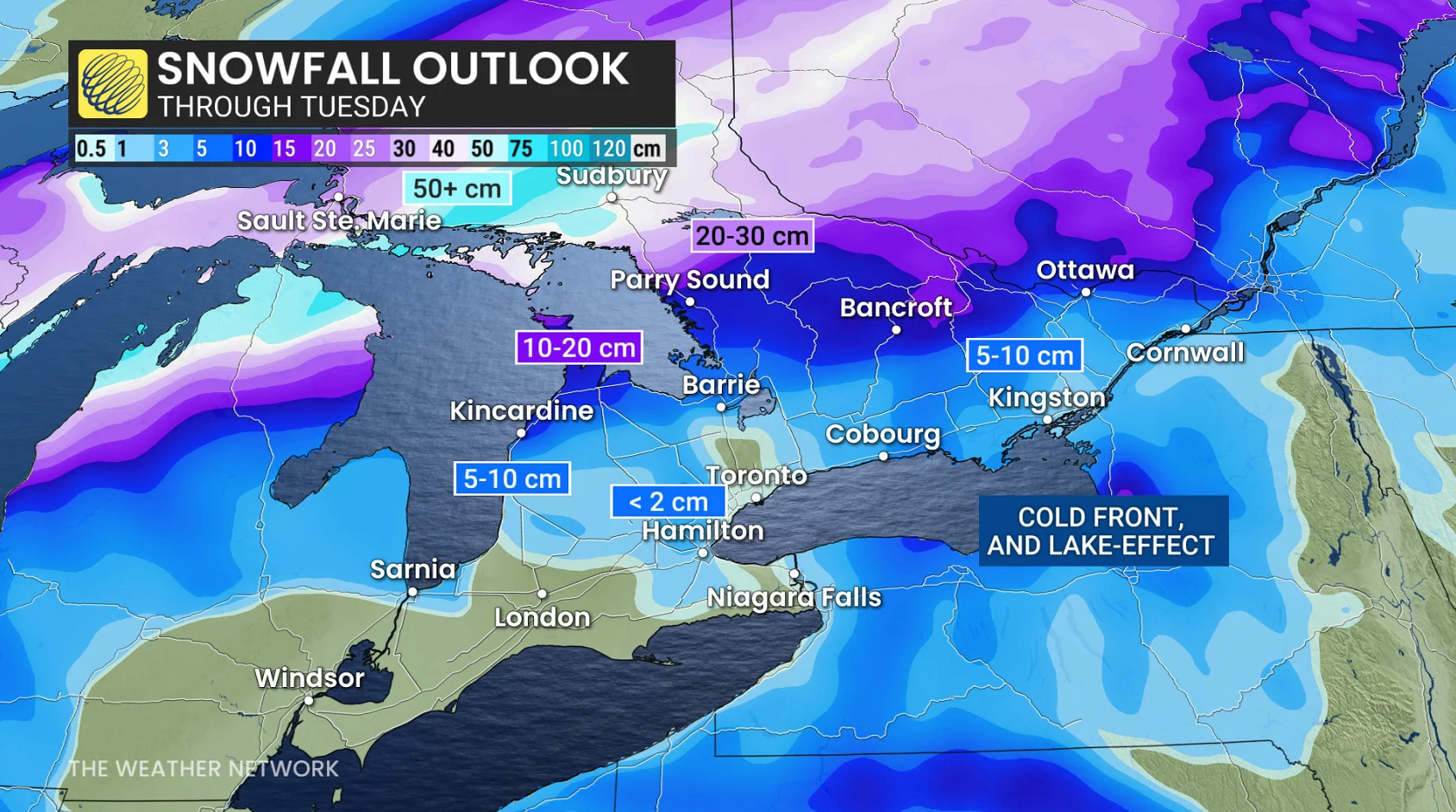
5-10 cm of snowfall is forecast in less than six hours east of the Greater Toronto Area (GTA), including for the National Capital Region, the same locales that will likely reach the 20-degree mark by late Monday.
No significant snowfall for the GTA, but lake-effect bands are streaming off Lake Huron and Georgian Bay, where locally 15-20 cm is possible through Tuesday for the snowbelts.
Temperatures will fall Monday evening into Tuesday, with wind chills in the -20s for northern Ontario and negative teens in the south.

Temperatures on Tuesday are up to 25°C to 30°C cooler than on Monday afternoon for extreme eastern Ontario and portions of the GTA.
Temperatures forecast to be 10°C to 15 °C below seasonal, with highs struggling to get much warmer than the mid-teens in the north.
Also on Tuesday, a lake-effect signal will still be present off of Lake Huron and Georgian Bay, meaning localized, heavy accumulation of snow.