Waterspout watch on the Great Lakes on Wednesday amid cooler setup
With the warmer-than-usual waters of the Great Lakes and a cooler air mass hovering over the region, the risk for waterspouts and lake-effect showers will be elevated for Lake Erie and Lake Ontario on Wednesday
Waterspout season on the Great Lakes officially arrived at the beginning of the month, and with much cooler air in place in southern Ontario now, an opportunity to see the watery funnels will occur on Wednesday.
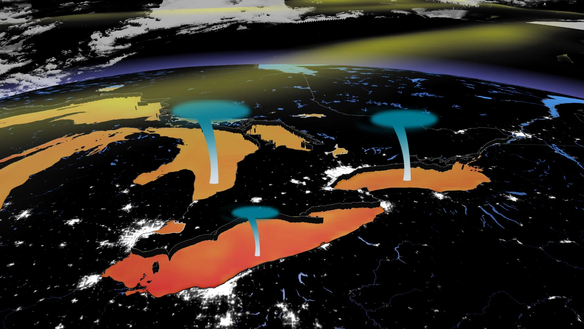
Waterspouts can develop as air rises into a developing cumulus or cumulonimbus cloud over the water. If the rising air begins spinning, it can swirl faster as it stretches vertically toward the cloud. Waterspouts are different from tornadoes in that they don’t need a rotating thunderstorm—or a thunderstorm at all—in order to form.
SEE ALSO: Parts of Ontario end the 65-day heat streak as temperatures cool, rain moves in

With waterspout season in the Great Lakes basin underway since Aug. 1, lasting through October, above-normal water temperatures and cooler air temperatures about at the moment, that combination brings together the right ingredients for waterspout development on Lake Erie and Lake Ontario on Wednesday.
Wednesday sees cooler air fuel a waterspout and lake-effect shower risk on the warm Great Lakes
The Great Lakes have warmed noticeably in the past several months under the summer heat and sunshine. Water warms and cools its temperature much slower than air since it is a thicker medium.

Because of that, the Great Lakes water temperatures usually peak late summer and early fall, until cooler fall air masses begin infiltrating the region.
At the moment, Lake Erie temperatures are above 25°C--above normal for August (about 23°C).
On Wednesday, cooler air will move over the warmer waters of the Great Lakes. Air temperatures will run a few degrees below normal, a comfortable mid- to low-20s across Ontario.
This temperature contrast over the lakes leads to instability, often contributing to waterspout formation and lake-effect showers. The combination of a cooler air mass moving into southern Ontario, a strong, upper-level low, and relatively warm lake water temperatures creates an environment conducive to waterspout formation.

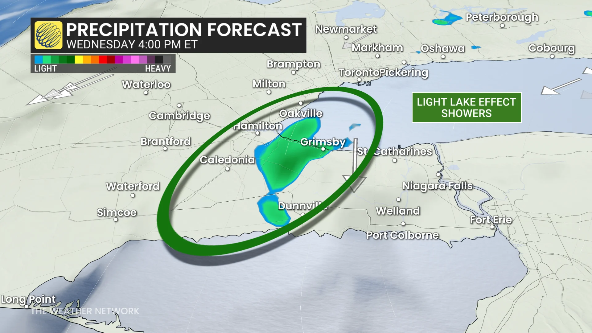
Forecasters are also watching the Hamilton region for lake-effect showers off Lake Ontario late afternoon on Wednesday, and onwards. The strength depends on the temperature difference between the water and air.
Showers will be relatively weak this time around, but expect the lake-effect to make a larger return in the fall months. They strengthen into the fall and winter as significantly colder air raises that temperature difference, creating stronger instability.
Not all of the Great Lakes will see the elevated risk. The chance for waterspouts will be greatest on Lake Erie and Lake Ontario on Wednesday.
There is a chance for waterspouts and lake-effect showers to continue early Thursday morning before high pressure moves in.
The winds will be coming from the north-northwest, so any waterspouts that do form will be tracking stateside.
Waterspouts are generally short-lived and weak in strength, but they can pose a hazard to boaters.
Occasionally, mature waterspouts could push ashore and cause some damage to land.
With files from Rachel Modestino, a meteorologist at The Weather Network, and Dennis Mersereau, a digital journalist and weather specialist at The Weather Network.