Volatile 'weather bomb' targets Newfoundland with 100+km/h winds, monster waves
A volatile fall storm, expected to become a weather bomb, will put Newfoundland in its crosshairs on Tuesday. Wild, possibly damaging 100+km/h winds, heavy rainfall and monster waves are possible, as well as the chance of new November low-pressure record in St. John's.
Weather Highlights:
A rapidly intensifying weather bomb is set to rapidly intensify on Tuesday morning, then cross Newfoundland by late Tuesday evening
Potential for St. John's, N.L., to see a new November low-pressure record
Eastern Newfoundland will see the strongest winds, with gusts of 90-100+ km/h, and more than 120 km/h near Sable Island and southeastern coasts, including St. John’s and the Avalon. Heavy, wet snow may occur in higher elevations of western Newfoundland and Labrador.
Rainfall of 30-60 mm (locally higher) is expected across parts of Newfoundland and Cape Breton, N.S., posing risks for power outages, downed trees, localized flooding, coastal erosion, and large waves reaching more than 6 metres.

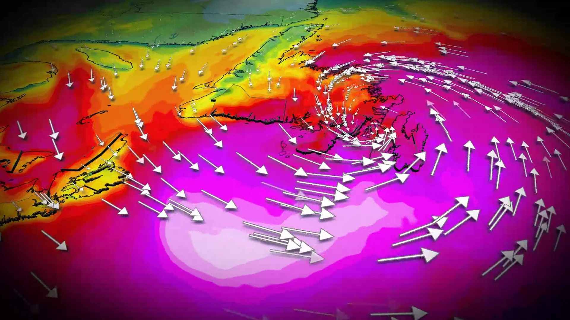
Timing the impacts, brace for outages:
The incoming Atlantic Canada storm will likely undergo bombogenesis-–a rapid deepening that turns the storm into a formidable low as it approaches Newfoundland on Tuesday.
DON'T MISS: 'Weather bombs': Explosive storms that create ferocious conditions

Heavy rain and gusty winds of 60-80 km/h will impact the Maritimes Monday overnight. Highest wind speeds along the Bay of Fundy shores, the Northumberland Strait and coastal Nova Scotia. Locally, up to 90 km/h for Cape Breton, N.S.
The heavy rainfall will lingers for Cape Breton through Tuesday morning before easing off in the afternoon.
Low will then lift northeast of Sable Island, dropping as much as 20 hPa of pressure in just a few hours.

Heavy rain will then spreads across Newfoundland late-Tuesday morning, with pockets of heavy, wet snow across the higher terrain of western Newfoundland.
Conditions will intensify as the low-pressure system reaches minimum pressure Tuesday evening and crosses the province at a record-breaking, deep pressure for November (approximately 950 mb).
St. John's, N.L., is likely to set a low-pressure record for November. However, it will fall short of the all-time, low-pressure record set back on Feb. 11, 2003.

Sustained, southerly winds of 80 km/h are likely across southeastern Avalon by Tuesday evening, with gusts exceeding 120 km/h, becoming southwesterly late in the evening as the system lifts across the region. Wind warnings are in effect.
Peak wind gust projections on Tuesday:
Trepassey: 120-130 km/h
St. John’s: 110-120 km/h
Burin: 110-120 km/h
Bonavista: 110 km/h
Gander: 90-100 km/h

The most recent gust that topped 100 km/h in St. John’s occurred on Feb. 15, while the last gust exceeding 110 km/h was recorded on Jan. 5.
DON'T MISS: Canada’s November features extended fall, but winter lurks on the sidelines
Localized flooding and coastal erosion a threat
The heaviest rainfall axis will be north of the track of the low, so Cape Breton, N.S., and central and western Newfoundland are forecast to see a widespread swath of 30-60 mm, with locally higher amounts possible.

Rainfall forecast:
Sydney: 50-75 mm
Port aux Basques: 40-60 mm
Burgeo: 40-60 mm
Gander: 40-50 mm
St. John's: 30-40 mm
Halifax: 20-40 mm

Impacts may include power outages, downed trees, minor structural damage, localized flooding in Cape Breton and Newfoundland, as well as coastal erosion due to monster waves reaching 6-8 metres.
By Wednesday morning, the powerful low lifts northeast of the province, with winds gradually easing and precipitation becoming more scattered through the afternoon.

Stay updated as the storm progresses. Weather conditions will likely present risks for travel and infrastructure in the region.
WATCH: How a 'weather bomb' forms and what it means
Stay tuned to The Weather Network for the latest forecast updates for Atlantic Canada.