
Tropical Storm Melissa to intensify, 'life-threatening' flooding expected
Melissa is expected to move closer to Jamaica and the southwestern region of Haiti over the next couple of days. The storm is forecast to strengthen into a hurricane within days and could become a major hurricane by the end of the weekend. Stay alert
Weather Highlights:
Melissa is forecast to bring heavy rainfall to parts of the Dominican Republic, Haiti, and Jamaica through this weekend. Significant flash flooding and landslides are possible in affected areas
Preparations to protect life and property should be completed by Thursday
Residents in other parts of Hispaniola and Cuba should closely monitor updates
Melissa poised for rapid intensification, significant impacts in the Caribbean
Melissa remains a tropical storm, though its structure has weakened compared to Wednesday. The storm's slow movement northward over the next 36-48 hours will begin to shift westward into the weekend, influenced by a mid-latitude ridge.
Favourable hurricane development conditions lie ahead for Melissa.
DON'T MISS: Hurricane forecasts are better today than ever before—here’s how
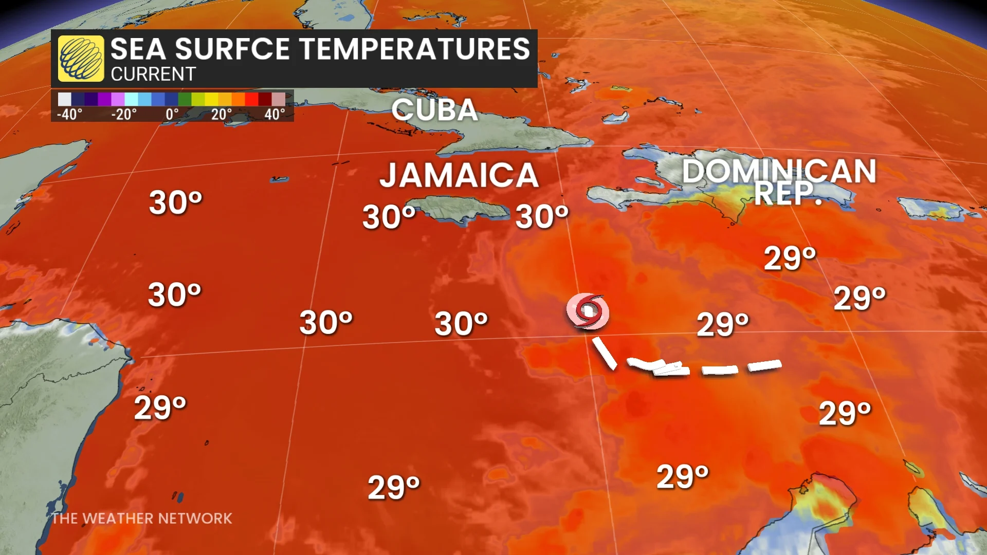
Sea surface temperatures in the region it will enter this weekend are 30°C, up to 2°-4°C above average. Combined with high mid-level moisture, these conditions could fuel rapid intensification.
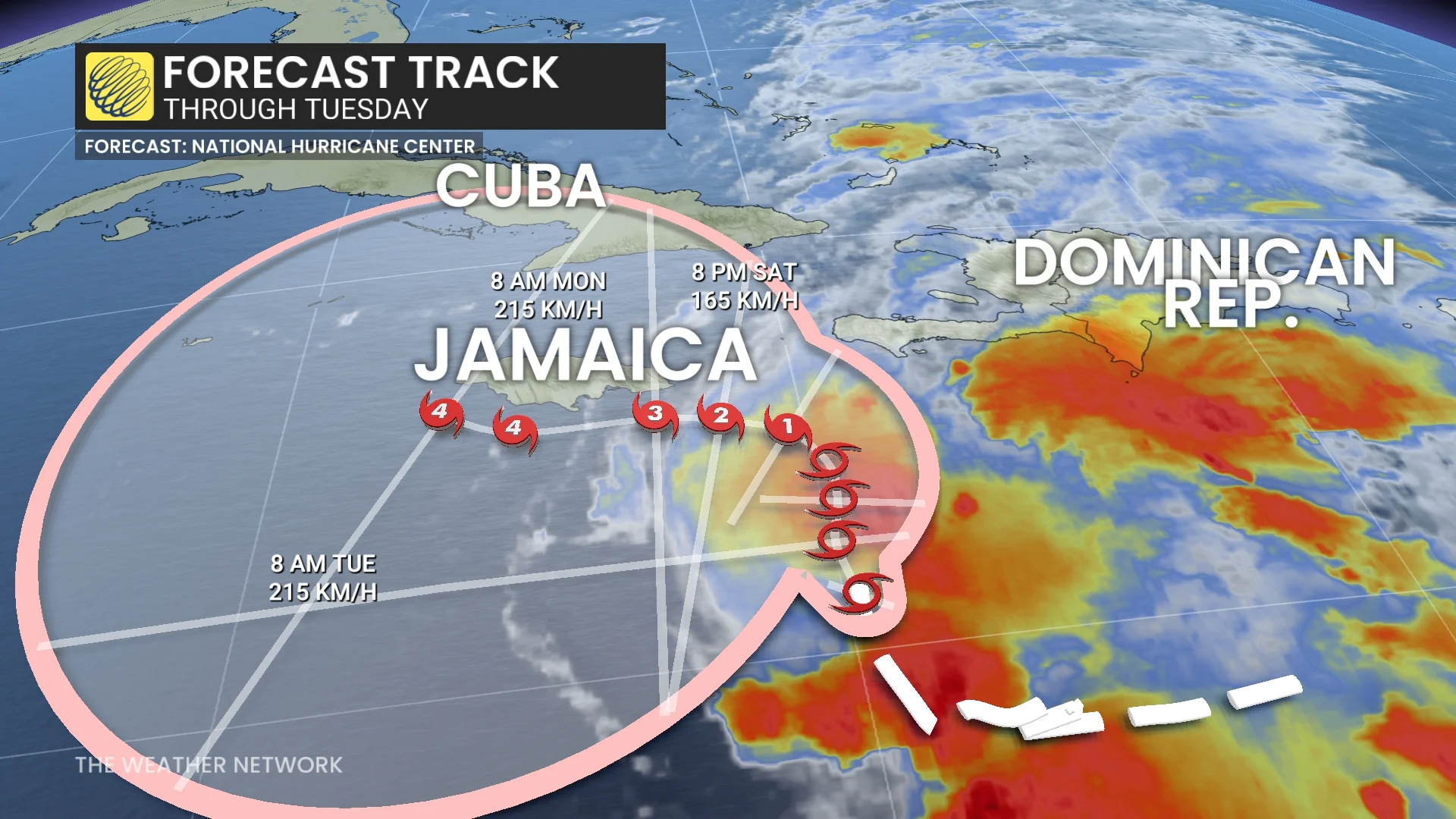
Melissa is forecast to become a hurricane by Saturday evening, and may intensify into a major hurricane (Category 3) by Monday. Melissa could potentially reach Category 4 status by Tuesday. The U.S. National Hurricane Center (NHC) anticipates peak winds nearing 210 km/h on Monday.
If Melissa reaches Category 4, it would rival Hurricane Gabrielle for the strongest storm of the 2025 Atlantic season. Gabrielle's peak winds reached 225 km/h.
DON'T MISS: Winter-proof your home with a heat pump that even works in -30°C
Melissa’s slow progression is expected to keep the storm near eastern Cuba, Jamaica, and Haiti for several days, heightening the risk of prolonged impacts.
Jamaica is forecast to see the strongest effects, with potentially damaging winds, coastal flooding, and life-threatening flash flooding. Southern areas of Haiti and the Dominican Republic will face heavy rainfall, leading to flash flooding and landslides.

Melissa is forecast to deliver 150-300 mm of rain to southern Dominican Republic, southern Haiti, and eastern Jamaica through Sunday, with locally higher amounts possible. For northern Dominican Republic, northern Haiti, and western Jamaica, rainfall of 50-100 mm is forecast through Sunday. Additional heavy rainfall is likely beyond Sunday.
Mountainous terrain in the region further exacerbates risks.
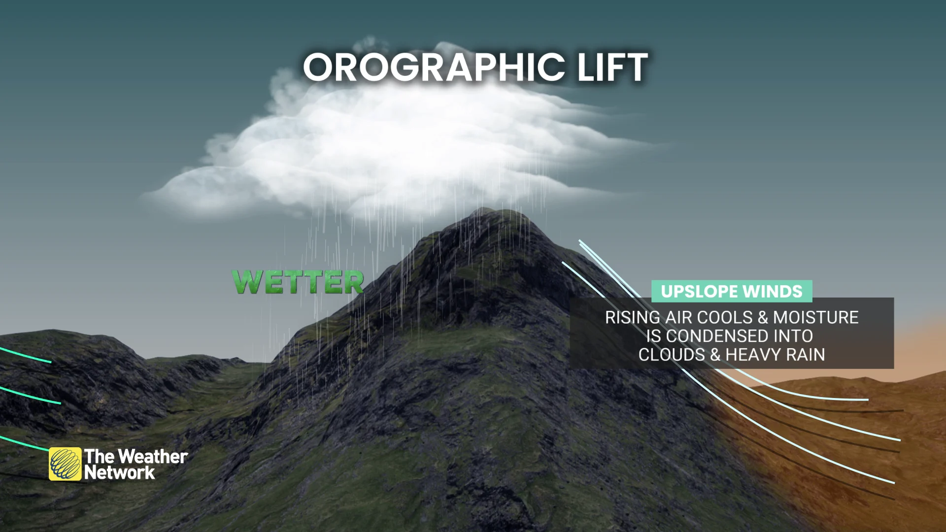
Orographic lift along the mountains will enhance rainfall totals, increasing the volume and velocity of runoff. This can result in catastrophic valley flooding, with debris adding to the dangers.
Residents in the affected regions should monitor updates and heed local advisories as the storm evolves.
RELATED: Autumn can still produce intense hurricanes across the Atlantic
It’s too early to determine the storm's potential impact along the U.S. coast. However, Melissa has a higher chance of approaching the U.S. compared to storms that have stayed further out in the mid-Atlantic earlier this season.
Monitoring potential tropical developments in the coming weeks is still essential, especially with sea surface temperatures supporting future storm growth.
The Atlantic hurricane season officially runs through November 30.