
Threatening severe storms fire back up Friday across Sask., Man., NW Ont.
Thunderstorms will continue across parts of Saskatchewan, Manitoba, and northwestern Ontario on Friday. All eyes are on southern Manitoba and northwestern Ontario for an overnight severe weather setup.
A multi-day severe weather risk will continue Friday as high instability and powerful upper-level winds combine over portions of the southern Prairies and northwestern Ontario.
This volatile setup could produce strong to severe thunderstorms across the Saskatchewan on Friday afternoon and a damaging mesoscale convective system that will track across southern Manitoba and northwestern Ontario overnight. We could even see some tornadic activity with this setup.
Tornado warnings were issued in northern Ontario Friday morning as a strong line of severe thunderstorms swept across the region. The warnings were replaced with severe thunderstorm warnings shortly after.
Folks from Regina to Thunder Bay should pay close attention to the radar and monitor local watches and warnings amid rapidly changing conditions.
DON’T MISS: Heat and storms linger as August starts Canada's slide out of summer
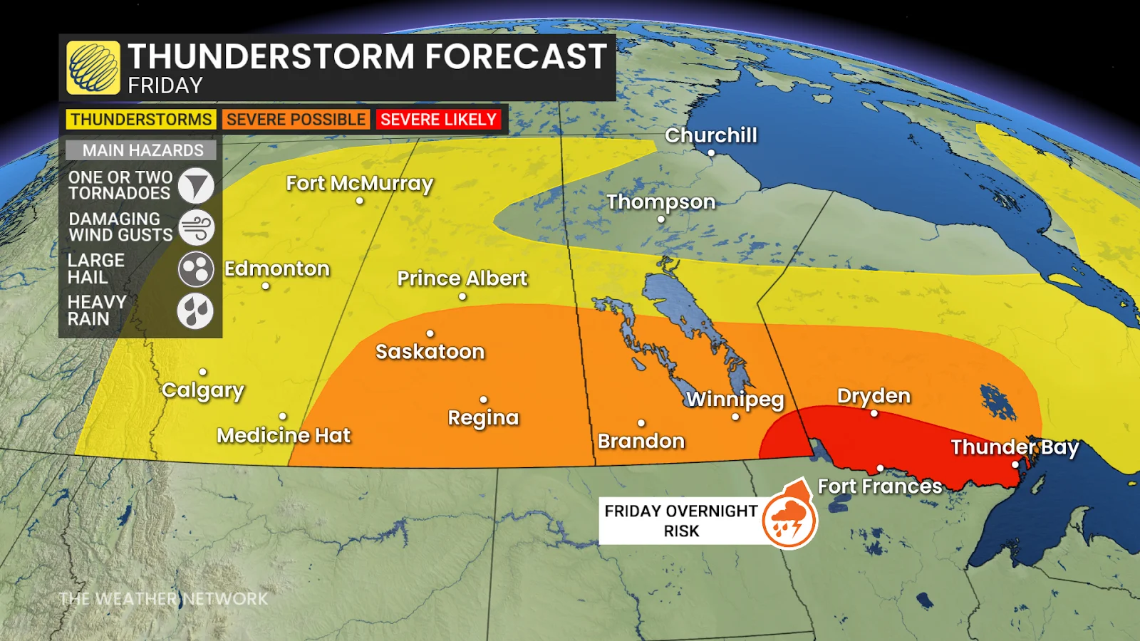
Friday: Severe storm threat expands into northwestern Ontario
We’ll see two main areas of activity across the Prairies during the day Friday.
First, we'll see a large low-pressure system move south and stall over southern Saskatchewan, supporting thunderstorms across the region during the afternoon. Some storms could produce 2-3 cm hail and maybe some funnel clouds.

While Manitoba and northwestern Ontario can expect clear conditions during the day Friday, all eyes are on the severe storm setup building into the evening and overnight hours.
Another low-pressure system moving across the northern U.S. Plains will push high instability and wind shear into southern Manitoba during the latter half of the day on Friday, helping to fuel severe overnight thunderstorms.
Supercell thunderstorms are possible, which could include the risk for 2+ cm hail, damaging wind gusts over 100 km/h, heavy downpours, and frequent lightning. A risk for an isolated tornado can’t be ruled out.
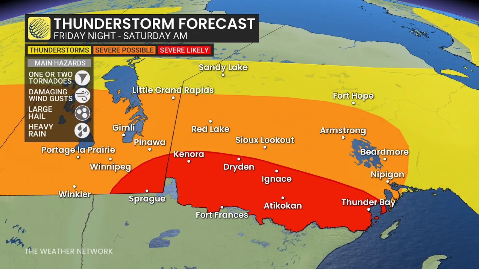
These storms could congeal into a mesoscale convective system (MCS) during the overnight hours Friday into early Saturday as they push east into northwestern Ontario.
Folks in Sprague, Man., as well as Kenora, Dryden, Ignace, Fort Frances, Atikokan, and Thunder Bay, Ont., should especially keep an eye on the forecast heading into the weekend.

Nocturnal thunderstorms are harder to see coming, making them even more dangerous. Folks camping should be sure to have a way to receive warnings and alerts, as well as a plan in place to seek shelter indoors.
Stay with The Weather Network for all the latest on conditions across the Prairies and northwestern Ontario.