
Tornado warning issued in Alberta as severe storms develop
Storms are expected to linger over Edmonton and surrounding regions as Alberta enters another period of unsettled weather.
6:18 p.m. MDT - Severe thunderstorms prompted a tornado warning in southern Alberta on Thursday evening.
Environment and Climate Change Canada issued a tornado warning for the following areas in southern Alberta:
M.D. of Willow Creek near Claresholm and Stavely

"This is a dangerous and potentially life-threatening situation. Take cover immediately, if threatening weather approaches," ECCC said in its warning.
The agency added: "Go indoors to a room on the lowest floor, away from outside walls and windows, such as a basement, bathroom, stairwell or interior closet. Leave mobile homes, vehicles, tents, trailers and other temporary or free-standing shelter, and move to a strong building if you can. As a last resort, lie in a low spot and protect your head from flying debris.”
CURRENT TORNADO WARNINGS (ALBERTA):
M.D. of Willow Creek near Claresholm and Stavely
The original article with the full forecast for Alberta continues below.
A slow-moving low-pressure system is projected to stall over central Alberta, bringing severe thunderstorms and heavy rain to Edmonton and surrounding areas this week.
Forecasters warn that the system could bring large hail, intense downpours and up to 75 mm of rain by the weekend.
DON'T MISS: Multiple systems fuel consecutive days of Prairies' severe storm risk
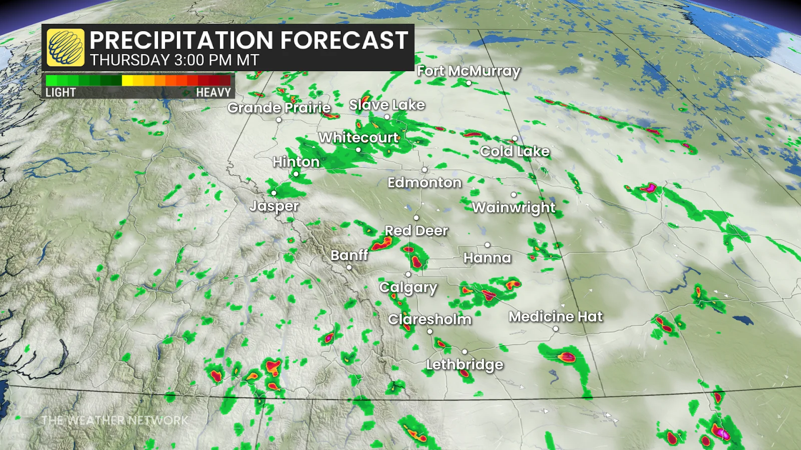
Thursday: Severe storm risk could impact travel
The unsettled pattern will not be changing any time soon. Rain is expected to continue through Thursday morning over the Edmonton area, with storm activity picking up again later in the day. The storm activity will lift northward and pick up in intensity by the afternoon, especially around Grande Prairie and Cold Lake.

Calgary, and Red Deer could experience some severe weather in the late afternoon, bringing a risk of heavy downpours, 2 cm hail, and strong winds. The timing and location on these risk could also impact travel along the QE2 and Trans-Canada Highway between Calgary and Medicine Hat.
CHECK OUT: Climate change helping rats thrive in Canada, experts say
There is also a chance we could see funnel clouds develop northeast of Edmonton, where upper-level temperatures are a bit cooler. Funnel clouds on their own are not much of a threat, but folks should be aware of them nonetheless.
Friday: Widespread rain comes with a cooldown
Friday morning brings widespread showers and cooler temperatures across the province.
Temperatures in Calgary may be just shy of the 20-degree mark on Friday, making it feel more like fall than mid-summer.
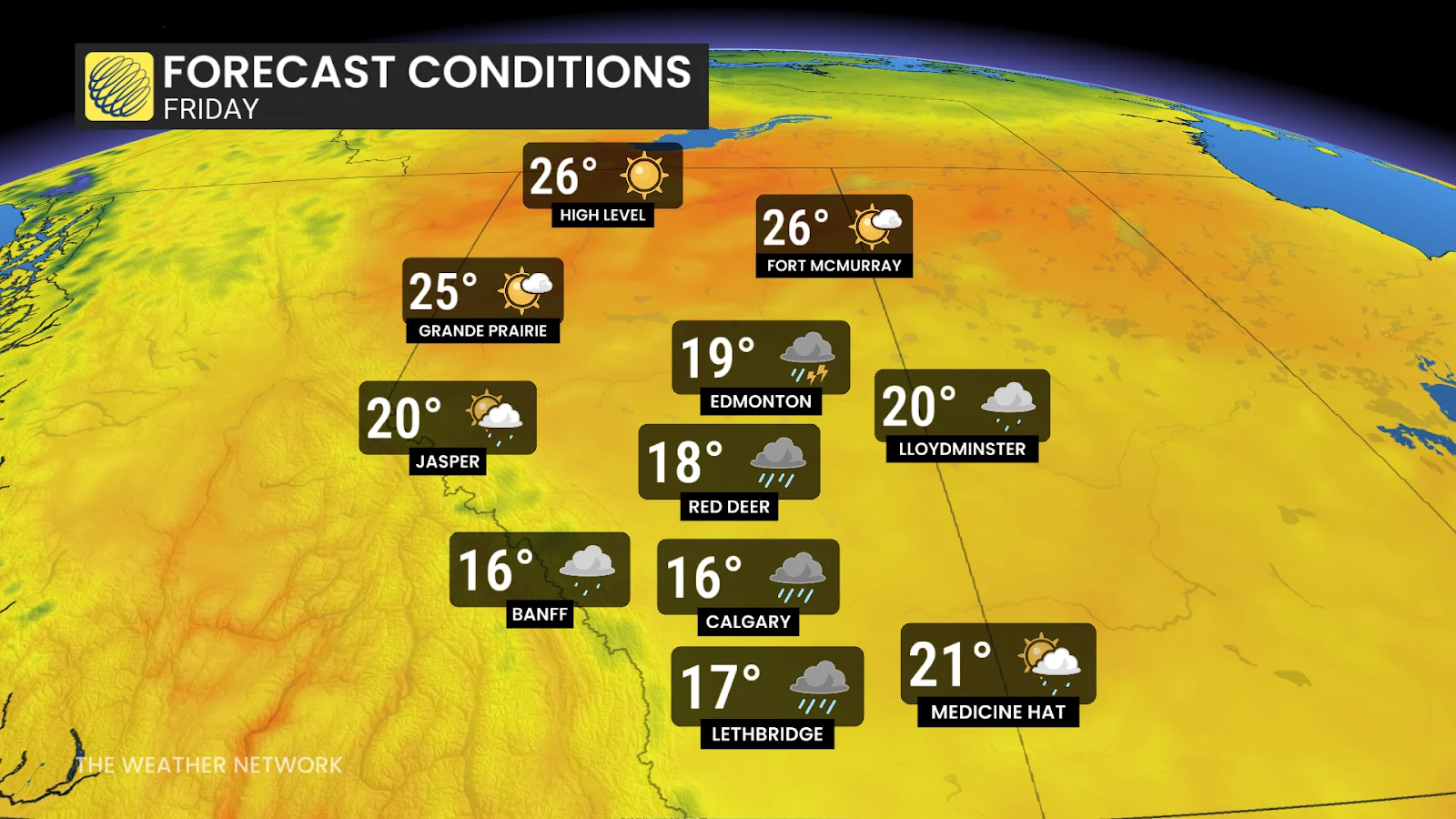
We could see some heavier downpours in the late afternoon and evening as the dreary system moves east into Saskatchewan, where a dying low sits.
Stay with The Weather Network for all the latest on conditions across Alberta.