
Storm risk in southern Ontario to offer rain relief for some drought-hit areas
A taste of humidity will accompany southern Ontario's storm threat, with some much-needed rainfall for some of the drought-stricken areas, for the next two days.
We’ve seen a very dry stretch of weather across most of the southern half of Ontario. Many communities were mired in a moderate drought or worse as of the end of August, with conditions only worsening through the first few weeks of September.
However, some relief is on the way, finally, on Sunday. While it won't be enough rain to erase the precipitation deficit completely, any amounts we see will be beneficial. Areas that see thunderstorms could see up to 50 mm of rainfall, which will increase the risk of localized flooding.
DON’T MISS: More dangerous than snow: Why driving in the rain can be a bigger hazard
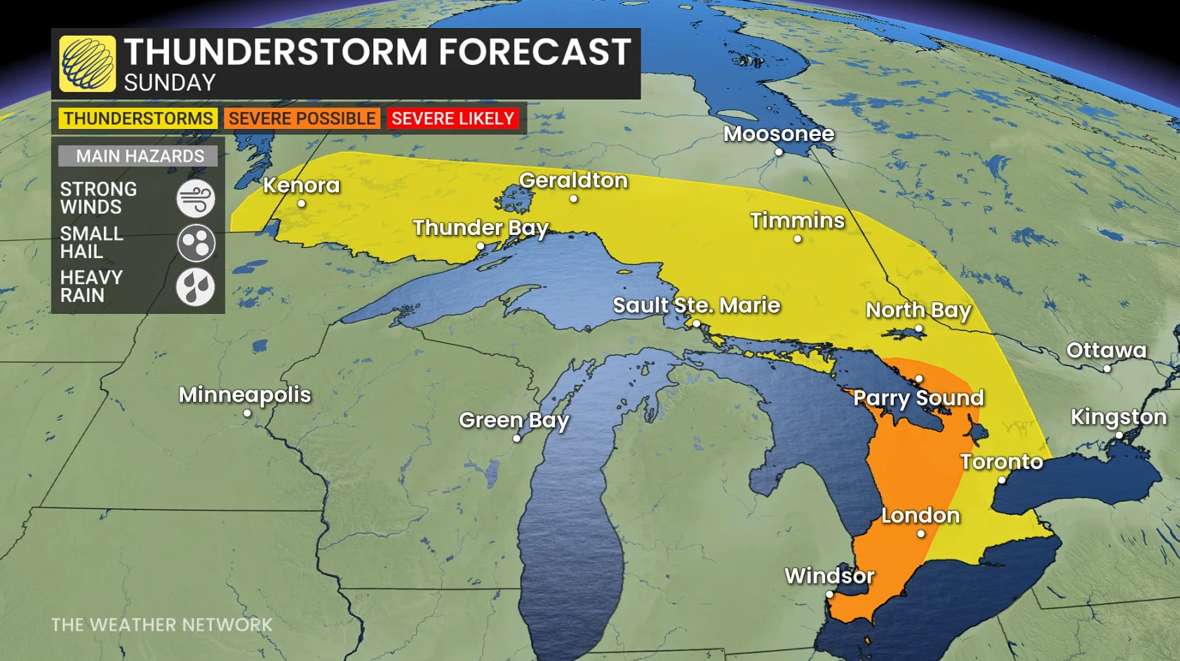
Along with the rainfall, Ontario could see its final severe thunderstorm threat of 2025 as a low-pressure system lifts across the province on Sunday. Blustery wind gusts topping 80 km/h, small hail and heavy downpours are the main risks.
It is important to remain weather-aware, and stay up-to-date on all of the latest watches and warnings as conditions change.
Ontario’s last shot at severe storms this season?
Conditions are just right to allow the storms to form. Saturday’s fall chill dropped temperatures, just as a warm air mass will move into southern Ontario along with a low-pressure system on Sunday.
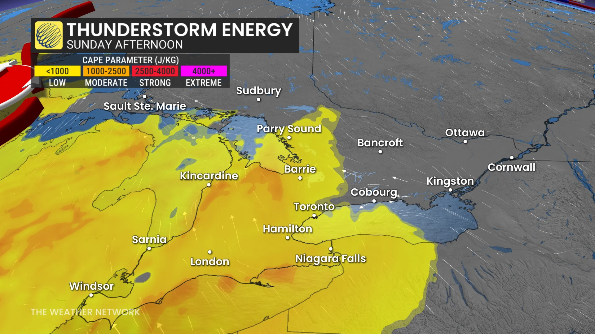
On top of that, moisture is building, with dew points climbing into the mid to upper teens; these factors are generating the right conditions for Sunday to see some thunderstorm energy build.
Still, the energy is modest-to-moderate, so nothing too intense, with thunderstorms expected to have gusty winds and small hail.
MUST SEE: Ontario's fall colours hang in the balance: Brilliant or browning?
The major parts of these storms will be the rain relief coming to combat the dry season.
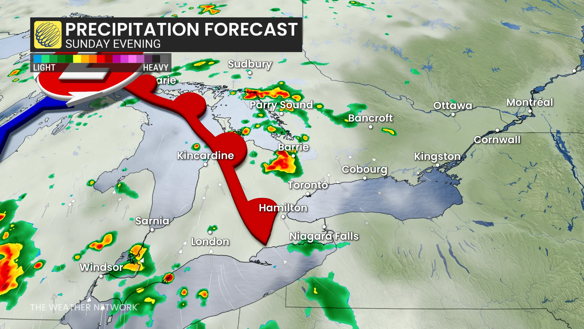
The thunderstorms will start developing after 4 p.m. near Lake Erie and the Bruce Peninsula, and then spread east.
Heaviest storm activity looks to be just north of downtown Toronto, and along the 401 and 407 corridors late Sunday evening.
There are some hazards to look out for. While the rain is good, drought-dry soil will be prone to localized flooding, and the rain is expected to be heavy.
Heavy downpours will bring hazardous driving conditions, with gusty winds exceeding 80 km/h in thunderstorm activity also contributing to the poor travel expected.
Storm developments will continue into the overnight as the low-pressure system pushes east, bringing the rain and thunderstorms with it. With the Greater Toronto Area (GTA) not expected to see a rumble till after 9 p.m., and lingering through the pre-dawn hours Monday morning.
This overnight pour will give Monday a muggy feeling, leaving humidex values sitting in the 30 range across southwestern Ontario.

That being said, regions that see the most organized downpours could accumulate close to 50 mm of rainfall, leading to the chance of some localized flooding.
While models predict the heaviest rain will drop in Bruce, Grey, Simcoe, Muskoka and Haliburton counties, with variable and lower rainfall amounts south of the 401 corridor.
Counties that have a greater chance of soaking rains include:
Northern Durham Region
Northern Grey County
Northern Kawartha Lakes
Northern Peterborough
Northern Wellington
Northern York Region
Southern Haliburton
Southern Perth County

But the ample moisture means lingering instability across southern Ontario, with more thunderstorm risk to come.
Temperatures Sunday overnight will remain exceptionally warm for the second half of September, with lows of 18°C forecast, close to an average high this time of year.
Mostly cloudy skies on Monday will limit available energy for stronger storms, but some partial clearing may allow more organized storm activity to bubble up late afternoon.
How bad is the rainfall deficit? Toronto-Pearson has only recorded 19.3 mm of rain so far this month, a far cry from the airport’s average September rainfall of 69.4 mm.
Stay with The Weather Network for all the latest on conditions across Ontario.