Spring denied: Ontario can't shake winter off its back
A lobe of incredibly cold air will swing over the Great Lakes over the coming days, fuelling a snowstorm in northern Ontario and triggering lake-effect snow in southern Ontario
Spring will continue to sputter along this week with periods of much colder-than-normal temperatures and snowfall in Ontario, much to the chagrin of residents wanting to move on from the wintry weather.
While it feels warmer on Sunday in southern Ontario--and will be on Monday again with a thunderstorm risk--giving folks a welcome reprieve from the recent bout of wintry weather, don't let it fool you. Wintry weather will soon return with a big bite for northern sections but the south will see some of it, too.
RELATED: Canada snags its first tornado of the year and the credit goes to...
Northern Ontario will be getting into the snow action first, potentially as much as 10-15 cm for areas along Highway 11 north of Lake Superior. Some of the snowbelt regions farther south will also see some lake-effect, but the accumulations will be noticeably less.
Be sure to monitor local weather alerts and check highway conditions before heading out to start the week.
Northwestern Ontario: Precipitation moves in Sunday night
The low pressure system inches across the international border into northwestern Ontario, bringing showers along the leading edge of the warm front.

Into Monday morning, the cold air on the back end infiltrates across the region, bringing heavy snow along Highway 17 between Dryden and Thunder Bay, as well as Highway 11. Gusty conditions are expected to cause poor visibility and slippery driving conditions.
DON’T MISS: Canada's capital plummets to a new (chilly) low
Thunder Bay is sitting right along the freezing line, resulting in a period of rain-snow mix through the day on Monday, accumulating minimal snow. However, rainfall amounts can be as high as 40 mm across the region.
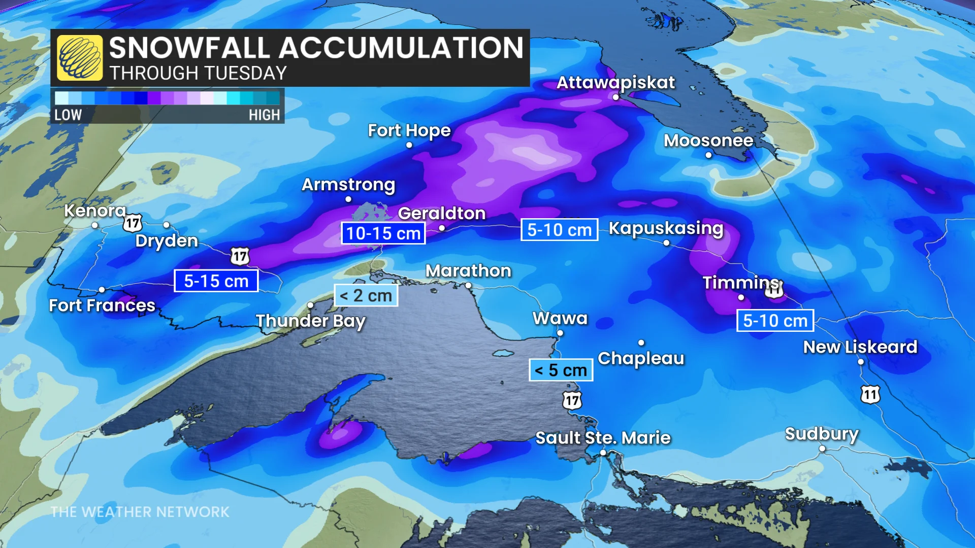
The heaviest snowfall occur along an axis along Highway 11 north of Lake Superior. As much as 10-15 cm is possible in those regions, with Thunder Bay expected to see less than 2 cm. Expect difficult travel, especially in the hardest-hit regions.
Southern Ontario: Warmth and thunderstorm risk before lake-effect snow returns
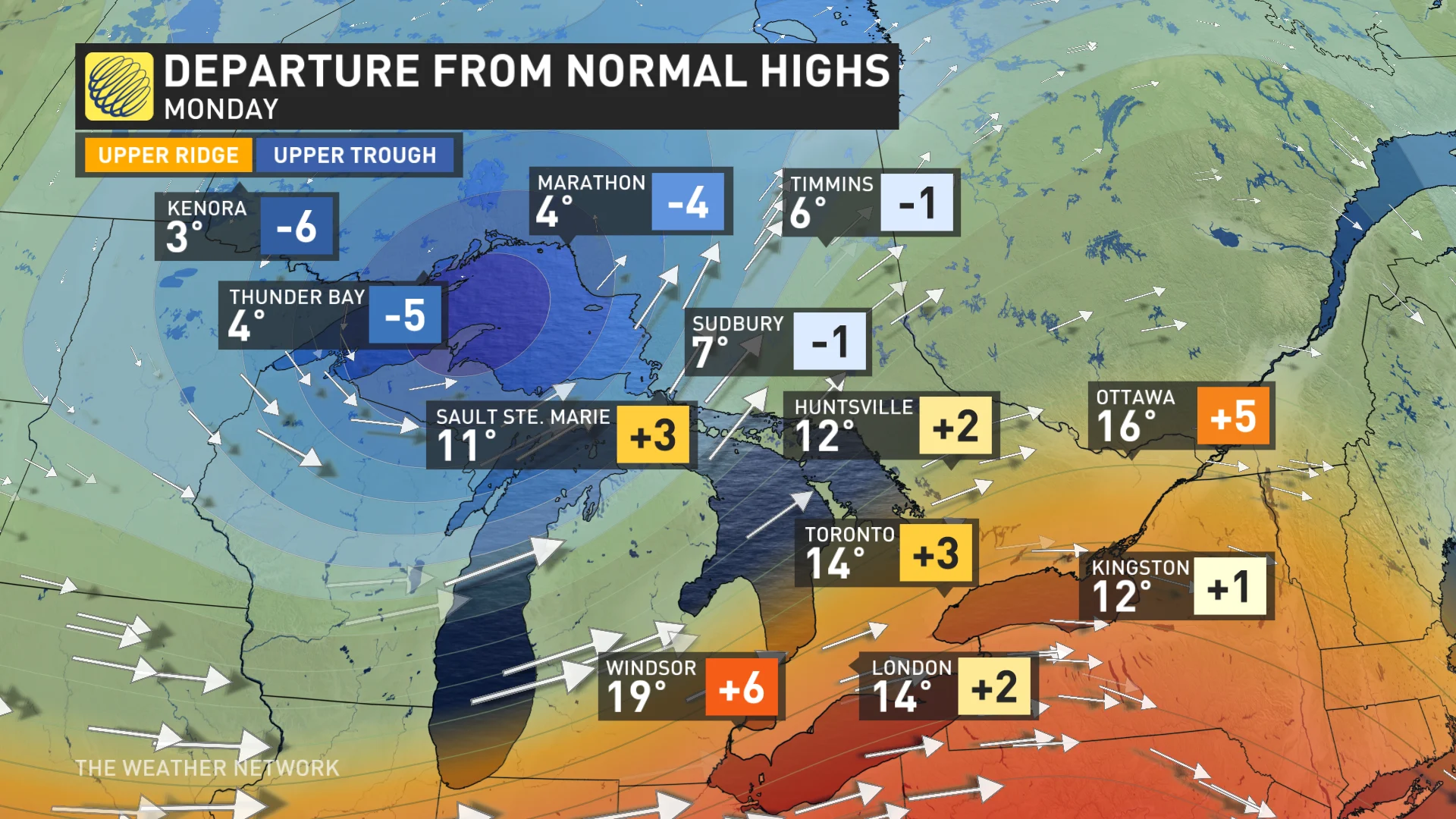
A warm front will nudges into southern Ontario early on Monday morning with a southeasterly flow, bringing temperatures above normal in southern Ontario briefly before the cold front shatters the spring conditions and ushers in the winter chill again. Widespread showers will impact southern Ontario through Monday afternoon.
Through Monday afternoon, don’t be surprised if you hear a rumble or two. There is the potential of some isolated thunderstorms occurring along the cold front east of the escarpment, but not everyone will hear a rumble. Expect heavier rainfall accumulation within the thunderstorm activity.
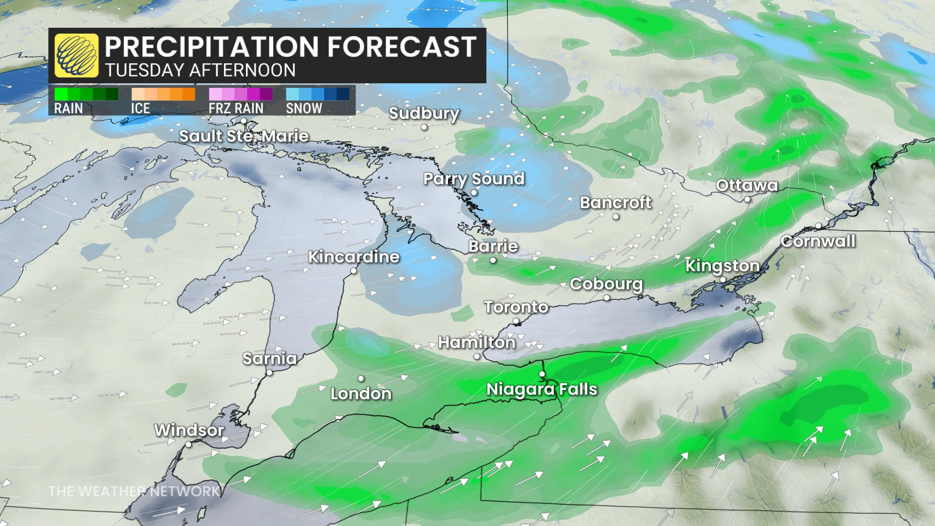
As the cold front departs, cold air is ushered back into the region, bringing in gusty conditions and lake-effect snowfall. The trough on the back end swings through, kick-starting the lake-effect machine Tuesday morning along the shores of Lake Huron and Georgian Bay––continuing until Wednesday morning.
Wind gusts across southern Ontario are expected to reach 60-70 km/h, while exposed regions along Lake Huron could reach closer to 80 km/h.
The heaviest accumulation amount is expected to stay along the escarpment where other regions should average around 2 cm.
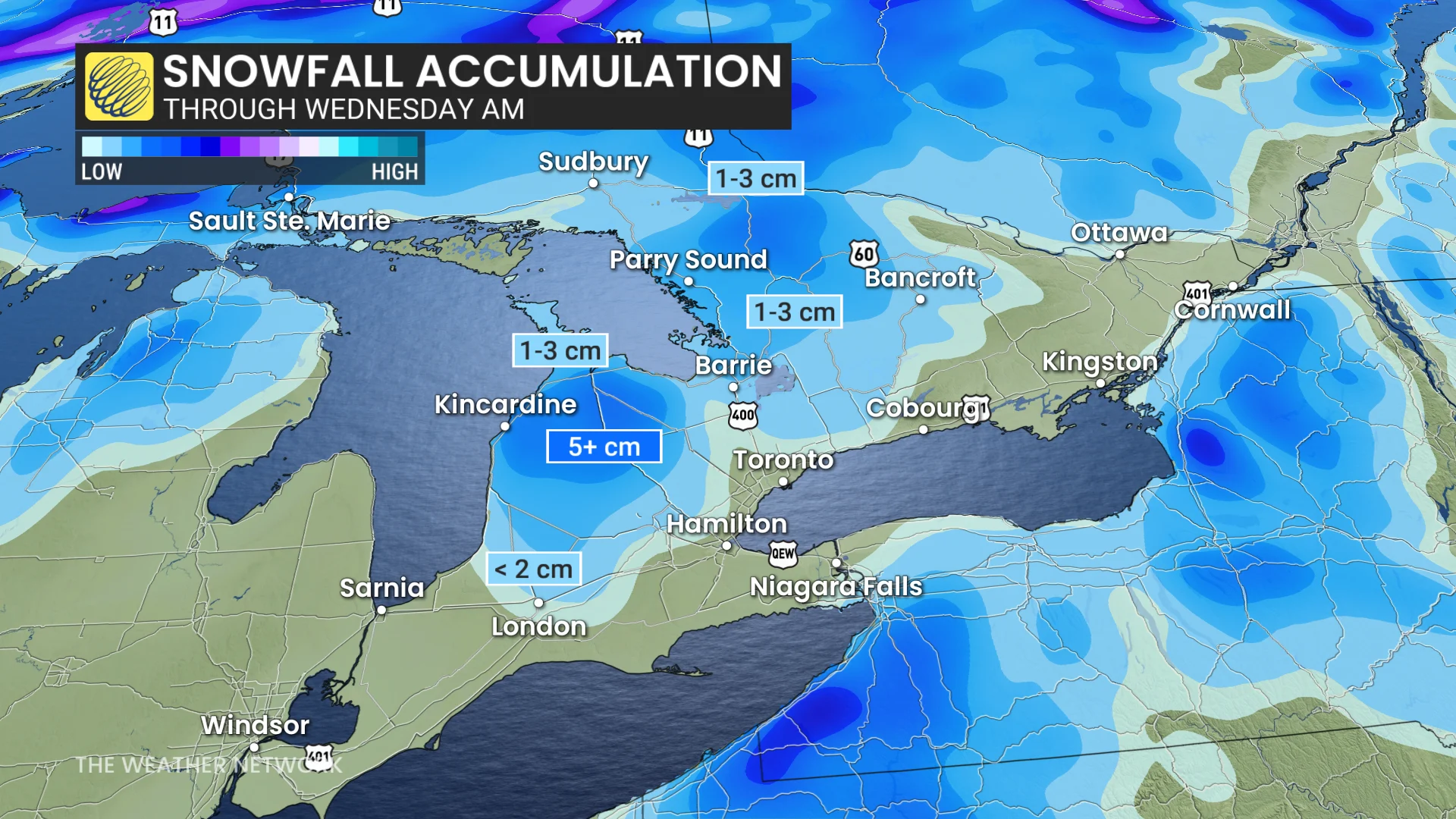
Some flurries may make it into the Greater Toronto Area (GTA), as well, but they will not be sticking around. Parry Sound could see 1-3 cm of snowfall, with a chance of 5+ cm along the escarpment.
More wintry weather expected, potentially for Easter weekend, before a warm reprieve (temporarily)
The temperatures fall below seasonal once again heading into Tuesday and Wednesday before they gradually begin to recover near the end of the week.
However, a reinforcing shot of Arctic air will keep temperatures below seasonal well into, and possibly through, the Easter long weekend.
However, we are closely watching the potential for a period of warmer weather as we head into the final week of April. This won’t flip the switch on the season as it appears to be a temporary pattern change, but several days of much warmer weather would be such a welcome break after a few weeks of chilly weather.
It is not uncommon to get snow in southern Ontario in April, especially in the traditional snowbelts regions, as lake-effect snow can continue this time of year. Even Toronto has recorded many snow days in April, and even two days in May.
Stay with The Weather Network for all the latest on conditions across Ontario.