
Soaking spring rains, stormy week ahead in southern Ontario
Spring in southern Ontario is showing its volatile side this week with multiple weather systems rolling through, potentially bringing significant rainfall totals and thunderstorms
Be sure to grab your umbrella before heading out over the next few days as a warmer pattern and multiple systems pushing into southern Ontario will bump up the chance for heavy rainfall and thunderstorms.
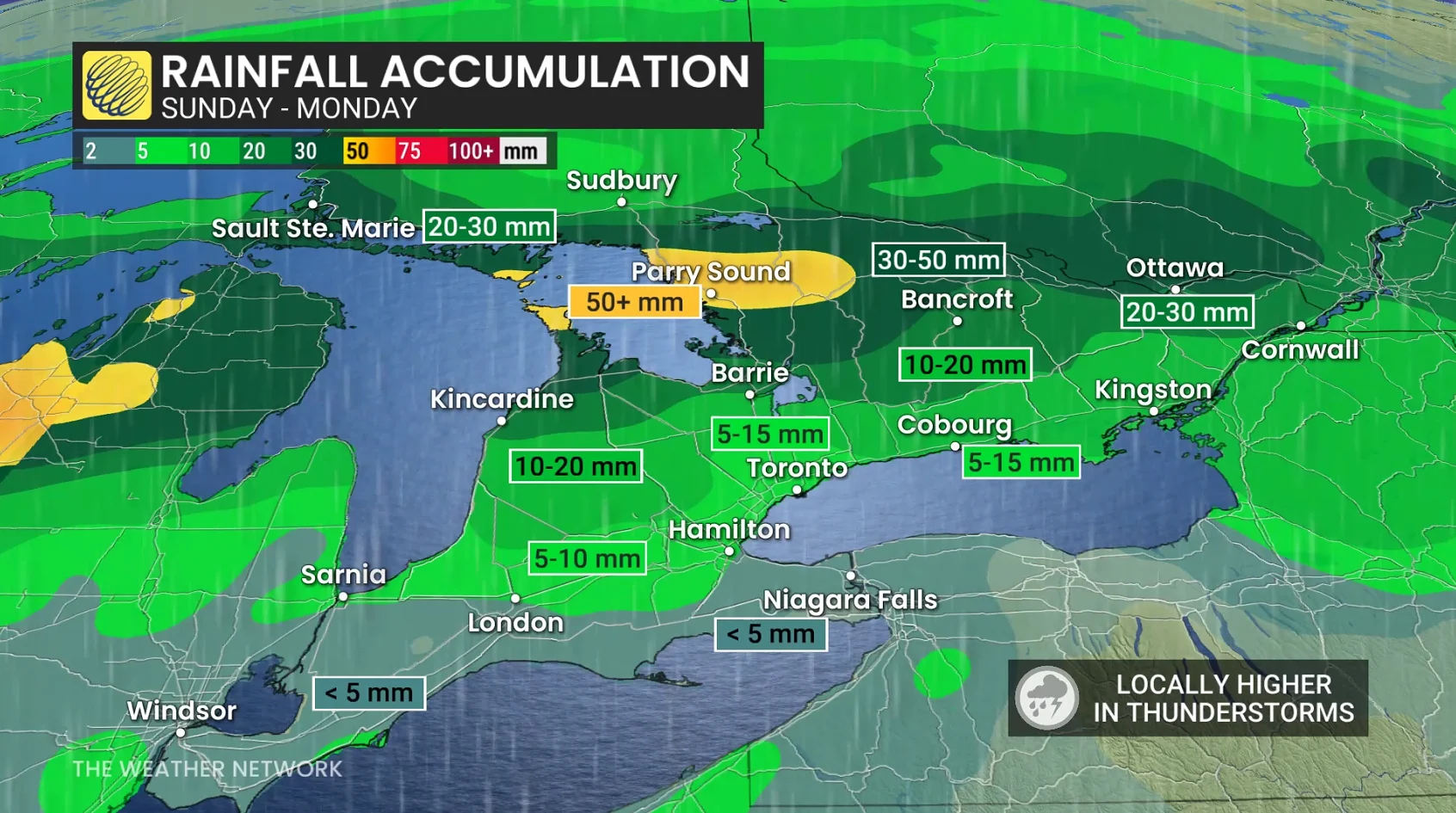
Some areas could see as much as 75 mm-100 mm of precipitation through the week ahead. Special weather statements and yellow-coded rainfall warnings are in effect.
DON’T MISS: Forecasters concerned about a growing El Niño this summer
Water will likely pool on roads and in low-lying areas. Don't drive through flooded roadways. Allow extra time for travel and avoid low-lying areas. Watch for washouts near rivers, creeks and culverts.
Warmer temperatures and heavy rain mark the start of this week
An active and unsettled pattern is in the forecast over the next couple of days. Several systems are expected to sweep across southern Ontario, including surges of remarkably warm temperatures for the middle of April.

Big temperature divide on Sunday with cool showers north and a mild, warm sector across southwestern Ontario.
The first wave of heavy rainfall will accompany a warm front lifting across the region on Sunday afternoon.
We’ll see the heaviest pockets of rain target cottage country and communities surrounding Georgian Bay, where amounts could locally push 30-40+ mm.

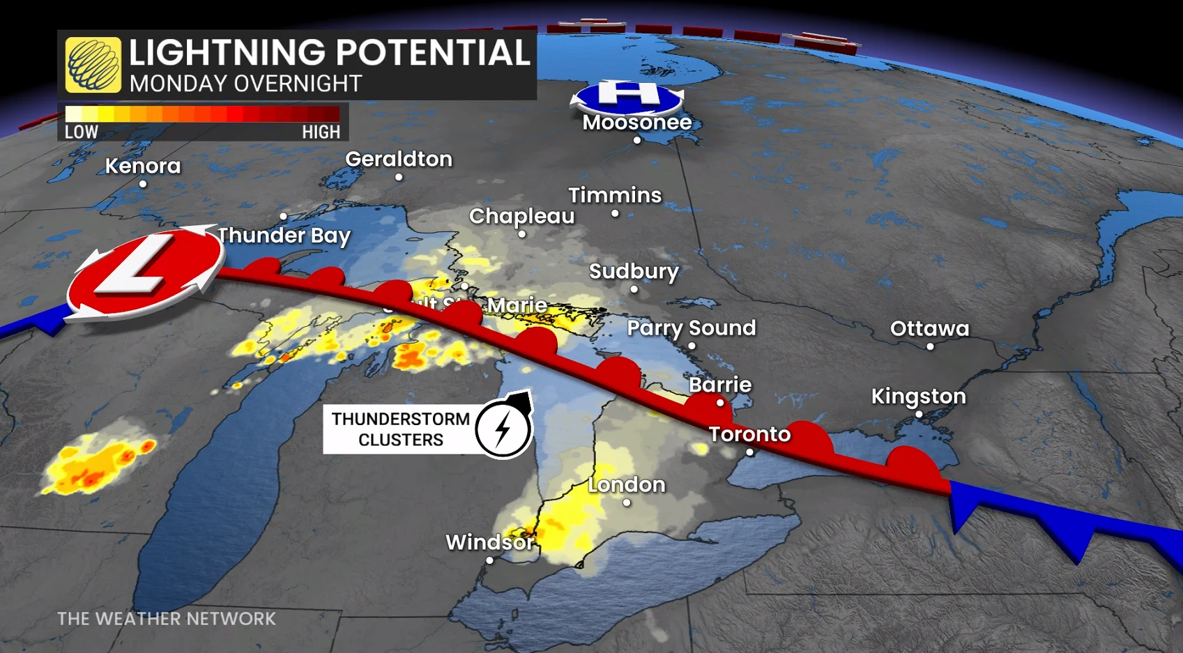
Additionally, a chance for thunderstorms will build Sunday evening into Monday along and ahead of the warm front. Locations near and north of cottage country and across northern Ontario are most likely. Heavy rainfall and frequent lightning are the biggest hazards.
Folks around the Greater Toronto Area (GTA) can expect generally less than 10 mm of rainfall through Monday morning, with higher amounts of 10-20 mm across northern sections of the region.
Early Monday morning, showers will continue across much of southern Ontario.
Monday will see mild temperatures from Windsor to Ottawa, featuring 18°C to 22°C highs, with a national hot spot forecast near Essex and Windsor.
Temperatures peak on Tuesday for the GTA inside the warm sector of another low-pressure system. These temperatures will also feature southwesterly wind gusts up to 60+km/h.
The next round of heavy rainfall is forecast on Tuesday, associated with a new developing low that slides across the Great Lakes, with the heaviest amounts associated with thunderstorm activity.
Tuesday morning: Clusters of storms are forecast to move in from the west across southern Ontario, prompting the threat of heavy rain--making for a slower-than-usual commute.
Tuesday afternoon-evening ahead of a cold front: Highway 401 corridor storms are forecast to be scattered and not widespread, but the risk will continue until more stable air flows in from the northwest.

Beyond, the soaking-wet spring signal continues this week, with some regions recording close to 100 mm of rainfall over the next seven days near Georgian Bay. Most other regions can expect 30-50 mm of rainfall, with locally higher amounts in thunderstorms.
As well, models continue to keep temperatures remarkably well-above seasonal through the week, upwards of 10°C above normal at times.
Temperature values are more typical of late-May than mid-April. Five or six consecutive days at 20°C is forecast for Pearson International Airport (Monday-Saturday), an exceptional feat for mid-April.

On average, April's typical record is less than three days above 20°C for the airport. More extreme warmth at Toronto's airport occurred during mid-April 2023 (29.4°C on April 12, 2023).
Be sure to check back for more on this potential as it draws closer.
WATCH: Are the early U.S. tornadoes bad news for Ontario's season ahead?
Stay tuned to The Weather Network for the latest forecast updates across southern Ontario.