20-40+ cm: Parts of southern Ontario face prolonged snow squalls
A prolonged, multi-day, lake-effect snow squall event is about to unfold in parts of southern Ontario. It could bring 40+ cm of snow to some areas, with hazardous travel conditions and reduced visibility expected, potentially leading to road and school closures
A major lake-effect snowfall event snow is shaping up for southern Ontario's snowbelt communities Thursday and Friday, with the hardest-hit areas expected to be near Lake Huron and Georgian Bay.
Snow bands will shift, spreading snowfall widely rather than targeting specific areas. Hard-hit regions could see 20-40+ cm, with blowing snow, drifting, and whiteouts likely due to 40-60+ km/h wind gusts through Friday.
DON'T MISS: New colour-coded Canadian weather alerts have now launched. Here's what they mean if you see them
These conditions will result in challenging travel conditions and possible road closures. Consider postponing non-essential travel.
Residents should stock up on essential supplies, such as food, water, medications, and batteries, and ensure their heating systems are working properly as soon as possible before the snow starts.
Visit our Complete Guide to Winter for an in-depth look at the Winter Forecast, tips to plan for it and much more!
Multi-day lake-effect snowfall event, with 40+ cm possible
Snow squalls will begin to form into Thursday, remaining unorganized through the morning period but intensifying through the afternoon.

Squalls will become more potent, stretching across regions of southern Ontario through the afternoon and evening hours, impacting many commuter routes and parts of the 400-series highways.
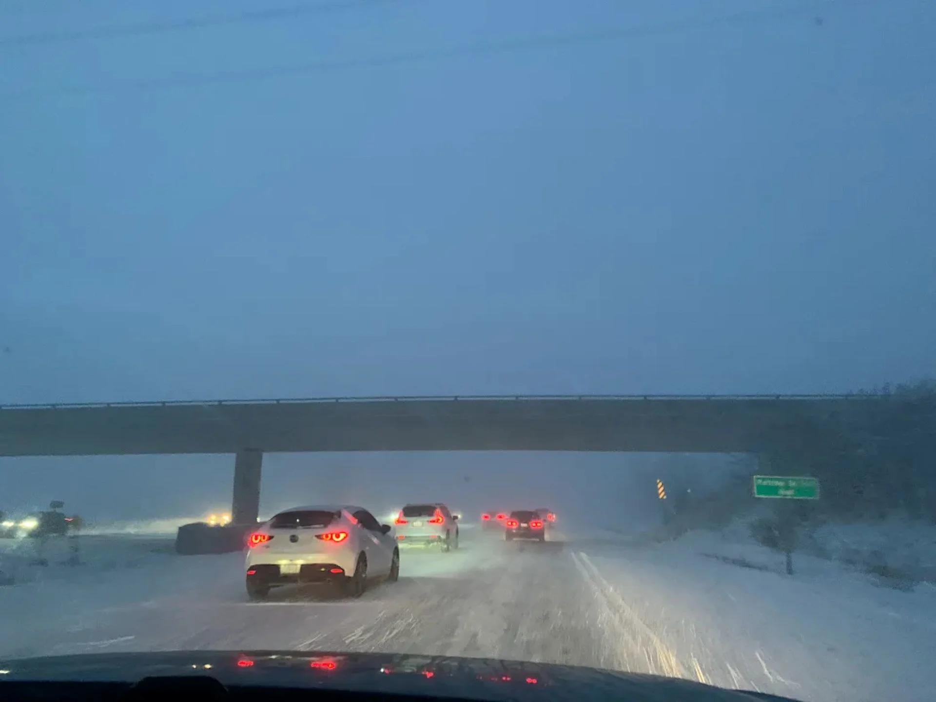
Prepare for dangerous travel with quick transitions from calm conditions to near whiteouts when entering snow squalls.
Gusty winds will continue through Thursday, with a general forecast of 40-60 km/h wind gusts. Along the lake shores, gusts of near 80 km/h can be expected.

Prepare for road closures to regions likely to get hit the hardest with the greatest snowfall accumulations. Highways 21, 6, 10 or surrounding routes could anticipate near zero visibility at times.
Monitor school closures Thursday and Friday for some counties in southern Ontario. Winds will continue to position to be out of the northwest through the evening and overnight.
DON'T MISS: Winter-proof your home with a heat pump that even works in -30°C

As winds are better aligned Friday morning, forecasters anticipate a couple dominate snow squalls to be the areas of concern through the day. One will travel off of Lake Huron, impacting regions near Goderich and stretch across highway 8, parts of the 401 south of KW, near Woodstock and across the 403.
The second squall off of Georgian Bay will deliver potent snow to communities near Lake Simcoe, including parts of the 400, 404 and into the eastern 401 Squalls and winds will howl through much of the day before breaking up in intensity Friday night into Saturday morning
RELATED: Thundersnow is a rare and electrifying experience

WATCH: Significant, wintry impacts expected through Friday in southern Ontario
Blizzard conditions threaten American Thanksgiving travel
For those travelling to the U.S. for American Thanksgiving, expect blizzard conditions in Michigan's Upper Peninsula and multiple winter weather alerts near Lakes Erie and Ontario.
Plan ahead and monitor updates.
Another weekend snow-maker to watch
Forecasters will be monitoring the potential for widespread snowfall this weekend across southern, central, and eastern Ontario, as well as southern Quebec.
While uncertainty remains about the track and intensity of the system, snow accumulations of 5-15 cm are possible across the affected regions.
If winter tires aren’t already installed, this is the final chance as the cold and active pattern appears set to continue.
Temperatures will trend colder through December, with below-normal values dominating. Brief periods of milder air may move north at times.
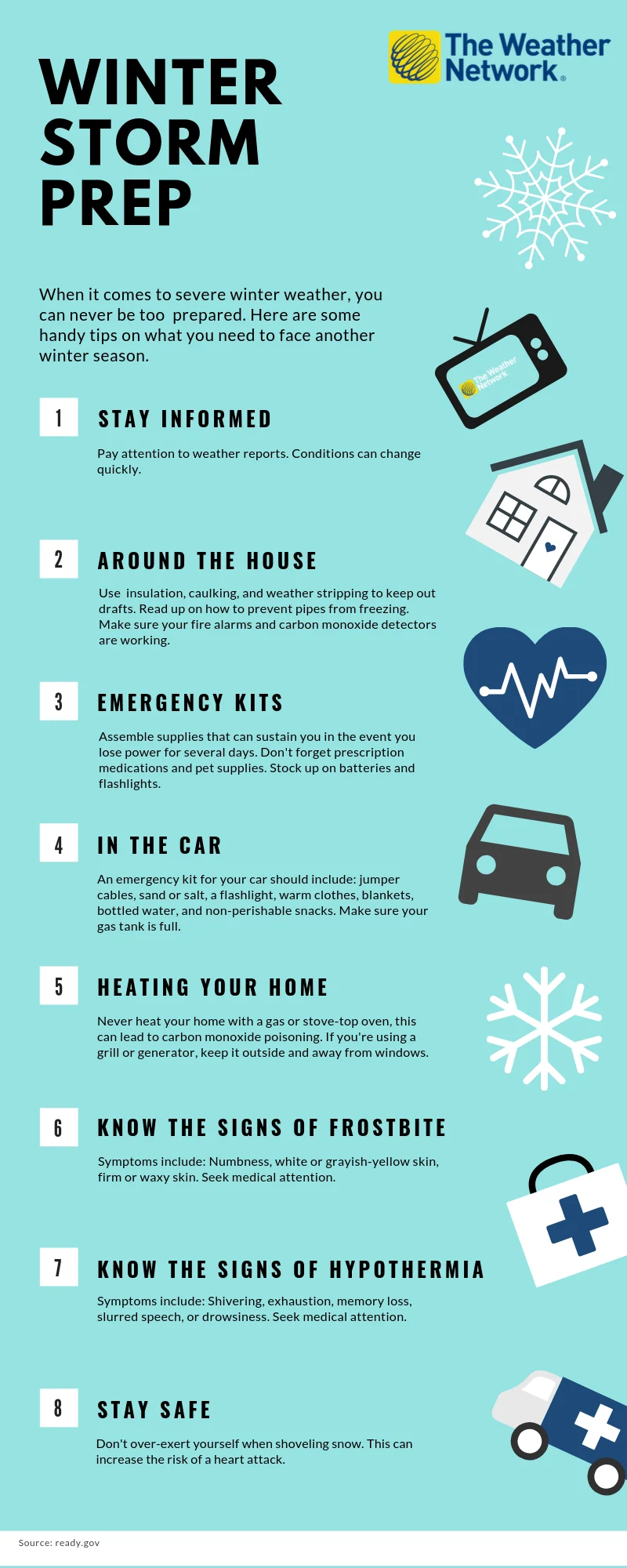
The time to prepare is now
When it comes to facing severe winter weather, you can never be too prepared. The infographic below has some handy tips on what you need to face another winter season.
Click here for a zoomable version of this graphic.
WATCH BELOW: Ontario's 2026 Winter Forecast: Get ready for a cold start to the season
Stay with The Weather Network for more information and updates on your weather across Ontario.