Sharp 10-20°C temperature drop and intense snow squalls hit Ontario
Cold front brings snow squalls to Ontario with 10-20°C temperature drop and dangerous wind chills
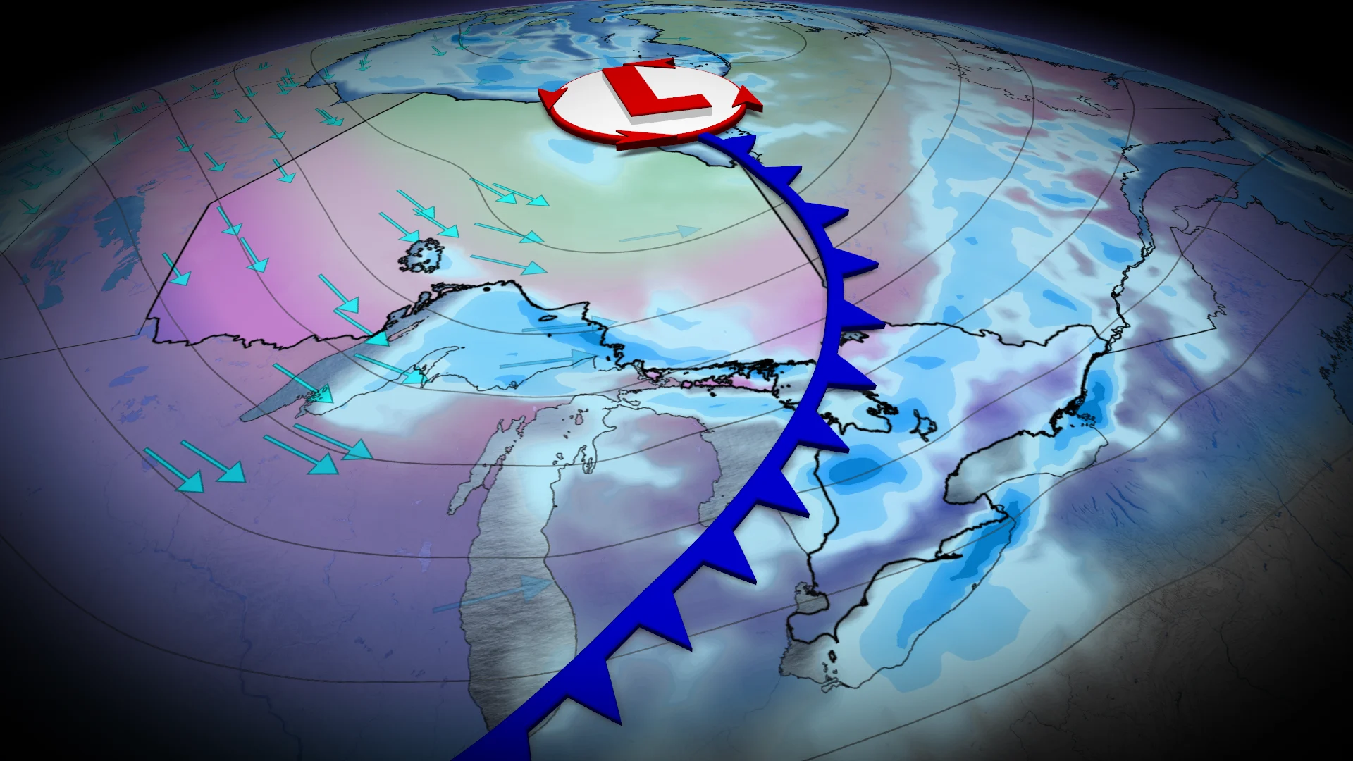
The polar vortex, currently over Hudson Bay, is extending into Ontario Thursday and Friday, delivering the coldest air of the season along with impactful lake-effect snow.
DON'T MISS: Canada’s December outlook holds a strong, cold start to winter
The Snow
As an Arctic cold front moves through, frigid air mixing with the warmer Great Lakes will fuel intense snow squalls starting late Wednesday and continuing through Thursday afternoon.

The heaviest snow is expected in southern Ontario’s snowbelt and the Lake Superior north shore, including Highway 17 between Sault Ste. Marie and Wawa, where 20-40 cm of snow is possible. Snow squall watches and warnings are in place.
SEE ALSO: Many Canadians dream of a white Christmas, but what are the odds of it?
Snow activity will diminish by Thursday afternoon as shifting winds from another system alter conditions.
The frigid temperatures that follow
Behind the snow, temperatures will plunge to 8-12°C below seasonal normals, with northern and eastern Ontario seeing the steepest drops.

Timmins could hit an early Thursday low of -27°C with wind chills dipping into the -30s.
Ottawa is expected to fall to near -18°C, feeling like -25°C, compared to its seasonal low of -8°C.

Toronto could see the coldest temperature of the season so far
Toronto may see its coldest temperature this season, dipping below -10°C Thursday night with wind chills near -17°C. Seasonal protection from the Great Lakes will help mitigate extremes in southern Ontario.
RELATED: When is the cold too cold? How extreme cold warnings are issued
According to the Canadian Red Cross, it is important for everyone enjoying the outdoors to know how to recognize when someone has been exposed to cold for too long, prevent cold-related emergencies, and be able to provide help when needed.
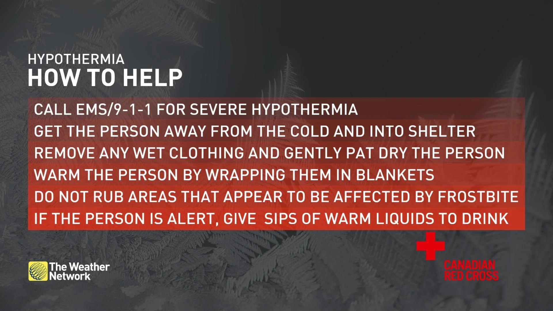
Prevention tips include:
Cover your head and trunk by wearing a hat and layers of tightly woven fabrics such as wool or synthetics.
Cover up exposed areas such as your fingers, cheeks, ears, and nose.
If your clothes get wet when you are in the cold, change into dry clothes as soon as possible.
Drink plenty of warm fluids to help your body stay warm and hydrated, avoid caffeine and alcohol.
Eat high calorie food and drinks regularly as the body converts food to energy which heats the body.
Dress in layers so that you can adjust to changes as you heat up or cool off.
Bring additional warm clothing when going out for extended periods or in case of emergency.
Don’t wear tight fitting clothing or footwear that may impair circulation.
Seek shelter from the wind if you are getting cold, even if it is only behind a tree, hill, embankment, or other landscape feature.