Tornado watch issued in northern Ontario ahead of storms Friday
Residents should prepare for an afternoon of thunderstorms and potential tornadoes
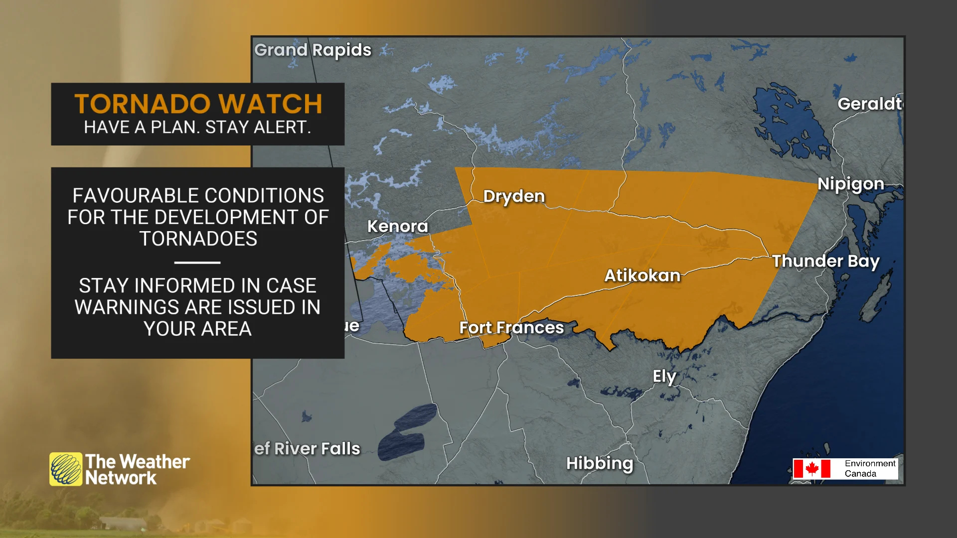
11:51 a.m. EDT - A tornado watch is in effect across portions of northern Ontario amid a threat for severe thunderstorms this afternoon and evening. A tornado watch means that conditions are favourable for the development of tornadoes.
Pay close attention to the latest alerts in case the tornado watch is upgraded to a tornado warning in your area. Have a plan in place to seek safe shelter in case severe weather threatens your home, your office, or while you’re driving.
CURRENT TORNADO WATCHES (Ontario):
Sioux Narrows - Nestor Falls - Morson
Dryden - Ignace
Fort Frances - Rainy Lake
Atikokan - Upsala - Quetico
The original article with the full forecast for northwest Ontario continues below.
It’s been a busy week for storms on the Prairies, and now all the ingredients are lining up for an active day of severe weather across much of northwestern Ontario on Friday.
Severe thunderstorms are likely across Fort Frances, Atikokan, and Dryden as a favourable environment spreads over the region to end the week. One or two tornadoes are possible.
Stay aware of rapidly changing conditions in your area on Friday. Keep a close eye on the radar as you go about your day.
Pay attention to watches and warnings issued for your community. Have a plan in place in case a tornado warning is issued for your location, whether you’re at home or on the road.
STAY SAFE: Tornado warning safety: Here’s what you should do
Severe storm risk grows through the day Friday
We’ll start the day Friday with some rain with embedded rumbles of thunder through the early morning hours on Friday.
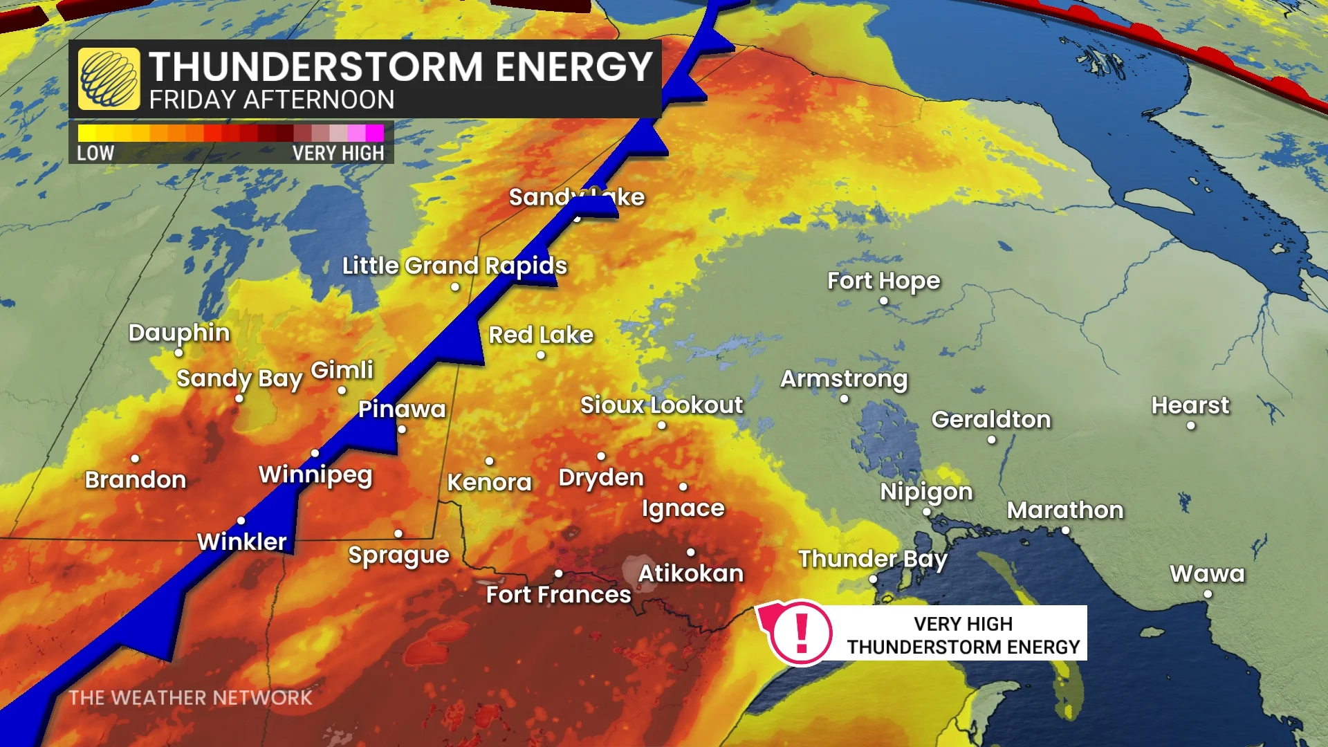
Heading into the day, forecasters expect high instability to build across northwestern Ontario and set the stage for robust thunderstorm development through the afternoon hours.
A cold front moving in from the west will serve as the spark that sets off thunderstorms by the late afternoon and into the early evening.
Friday’s severe thunderstorms will pose a risk for one or two tornadoes, as well as large hail up to 3-4 cm in diameter, damaging wind gusts of 90-110 km/h and localized flooding.
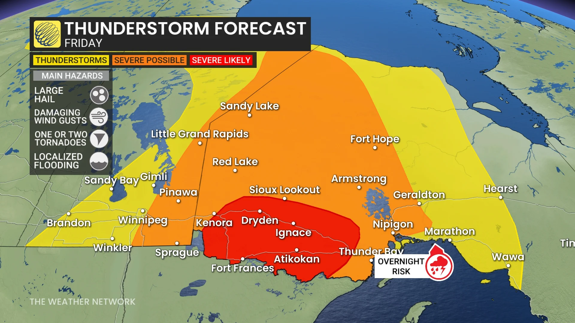
Severe thunderstorms are expected to bubble up first near Dryden, Ignace, and Fort Frances. These initial storms will pose a risk for tornadoes, especially close to the international border.
Fort Frances can expect to see that heavy rain as early as 2 PM CT, with a large buildup north of the town as thunderstorms start to set in.
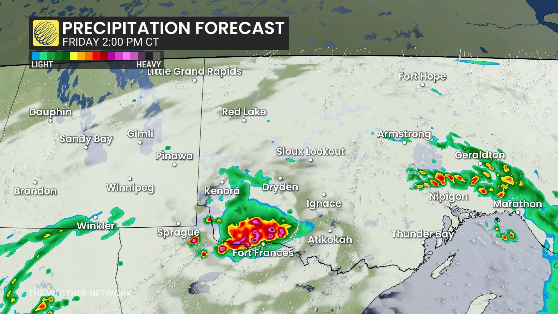
While in the late afternoon, you will be able to see the storms spread across to Ignace, putting a couple more areas under that heavy rain brought in by the thunderstorms.
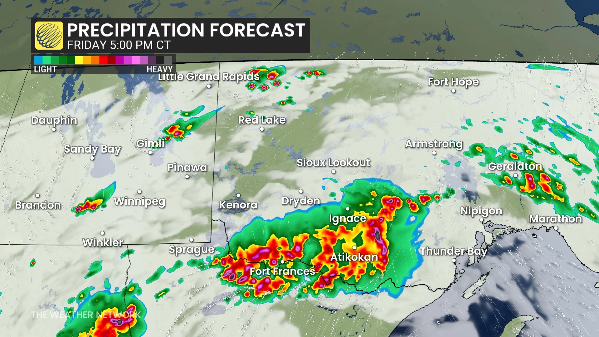
As the evening wears on, these individual thunderstorms will likely merge into clusters, at which point the threat will transition to damaging wind gusts with the potential for embedded rotation and large hail.
Make sure you stay aware of severe weather alerts in your area. To turn on severe weather alert notifications for your area, open The Weather Network App and go to settings, and then notifications.
Have a sheltering plan in place for tornado warnings whether you’re at home, at work, or on the road. The goal of tornado safety is to put as many walls and barriers as possible between you and flying debris.