
Severe drought spreads as a relentlessly dry pattern drags on
The unusually dry pattern gripping Eastern Canada through the first half of September will continue for at least another week
Severe to extreme drought conditions are spreading across the eastern half of Canada as an unusual lack of precipitation continues throughout the region.
The dry weather will persist as a ridge of high pressure looks to dominate conditions through the middle of September.
Canada's 2025 Fall Forecast: An extended pause could redefine the season ahead
Lack of rain pushes many areas into a drought
It’s been an extremely dry start to September across the Great Lakes and Eastern Canada.
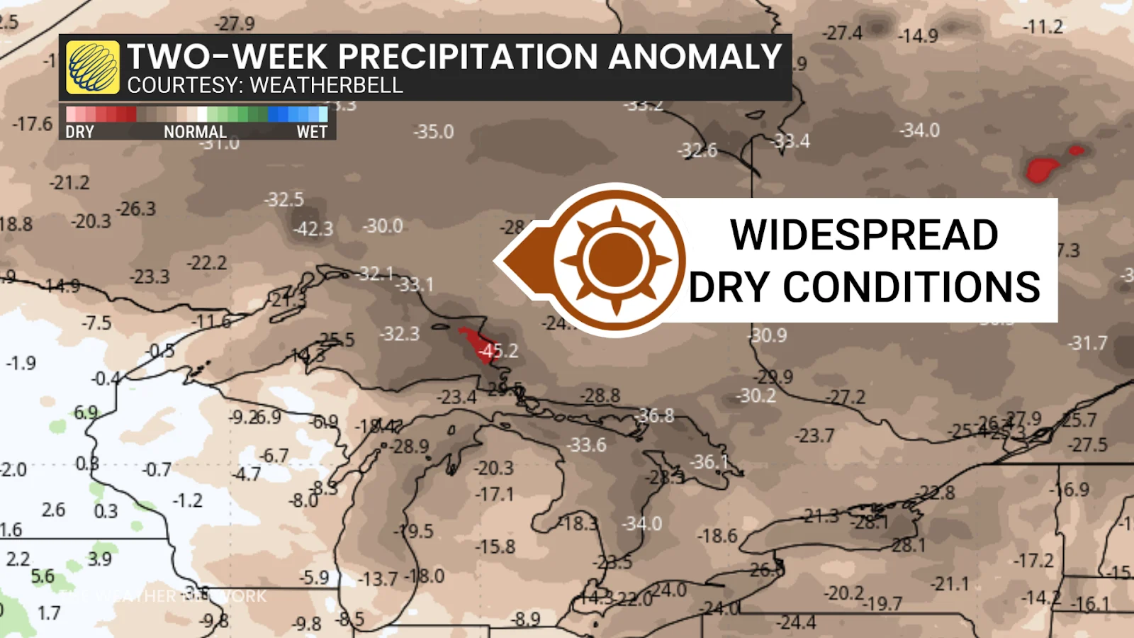
Ottawa only picked up 6.6 mm of rain between Sept. 1 and Sept. 12. Sudbury picked up just 13.5 mm of rain over the same period, while the first two weeks of the month brought Toronto just 19.3 mm of precipitation.
Most communities across southern Ontario and southern Quebec average around 30-50 mm of rain through the opening half of September.
All that calm weather has taken a toll. The latest update of the Canadian Drought Monitor showed August ending with widespread drought conditions from southwestern Ontario through Atlantic Canada.
Moderate to severe drought included Ottawa, Montreal, and almost all of the Maritimes. An extreme drought, the second-worst category, encompassed the Bay of Fundy shores, Prince Edward Island, and southeastern Newfoundland including St. John’s.

This extended dry stretch could have consequences for the region. A prolonged wildfire season is possible as fuels remain dry into the autumn. Low streamflows and water supply concerns will also develop amid the lack of precipitation.
It’s a similar situation south of the border. Pockets of drought conditions have developed over the past month from the Mississippi Delta to the Gulf of Maine.
New Orleans has only seen a trace of rainfall since the beginning of the month. Atlanta has only seen 0.5 mm of rain over the past two weeks. Very little rainfall is in the forecast over that region for at least the next week.
Driving factors include lack of hurricanes
Multiple factors carry blame for the lack of rainfall.
We’ve seen numerous ridges of high pressure settle over Eastern Canada in recent weeks, and it’s a pattern that’ll continue for the next week. Air sinks beneath ridges of high pressure, stabilizing the atmosphere to keep conditions relatively dry.

RELATED: How Omega blocks can affect Canada's weather
The relative lack of tropical activity we’ve seen through the first half of hurricane season has also played a role. Tropical systems making landfall in the U.S., as well as systems recurving through the western Atlantic, can bring drenching rains to Eastern Canada during the late summer and autumn.
There are signs, though, that hurricane season may grow much more active heading into the latter half of September into October. Sea surface temperatures in the Gulf of Mexico are about as warm as they’ve ever been for this time of year. Folks in both Canada and the U.S. shouldn’t let their guards down yet.
Ongoing drought conditions are also playing a role. Drought reinforces drought. Water evaporating out of moist soils can add crucial water vapour to the atmosphere. Dry soils reduce the chances of rainfall, and they warm faster, as well—a loop that can reinforce the high pressure stifling precipitation in the first place.
Header image created using graphics and imagery from Canva.