
September’s back-to-school tug of war: Summer heat meets fall chill

With students beginning to juggle homework and routines once again, Canada will be balancing heat waves with frosty mornings this month. Read below to get the full story for what to expect in September
September’s lesson plan is full of extremes this month. Just as students begin to juggle homework and routines, Canada balances heat waves with frosty mornings.
Summer isn’t ready to let go, though, delivering record-shattering heat in the West, while fall pushes back with frost and even the first snowflakes mixing in for parts of the Prairies and Ontario. Canadians will have to juggle two seasons at once as September begins.
DON'T MISS: A typical September sends Canada heat, frost, hurricanes, and snow
Lesson 1: A split start
The first week of September feels like a classroom divided.
Out in the West, summer is refusing to hand in homework, with record-shattering heat across B.C., portions of Alberta, and the Yukon. In the East, temperatures stay warmer than normal. Still, the middle of the country plays the role of strict teacher: Unseasonably chilly weather sweeps through the eastern Prairies and northern Ontario, bringing early-season frosts and even the season’s first snowflake sightings.

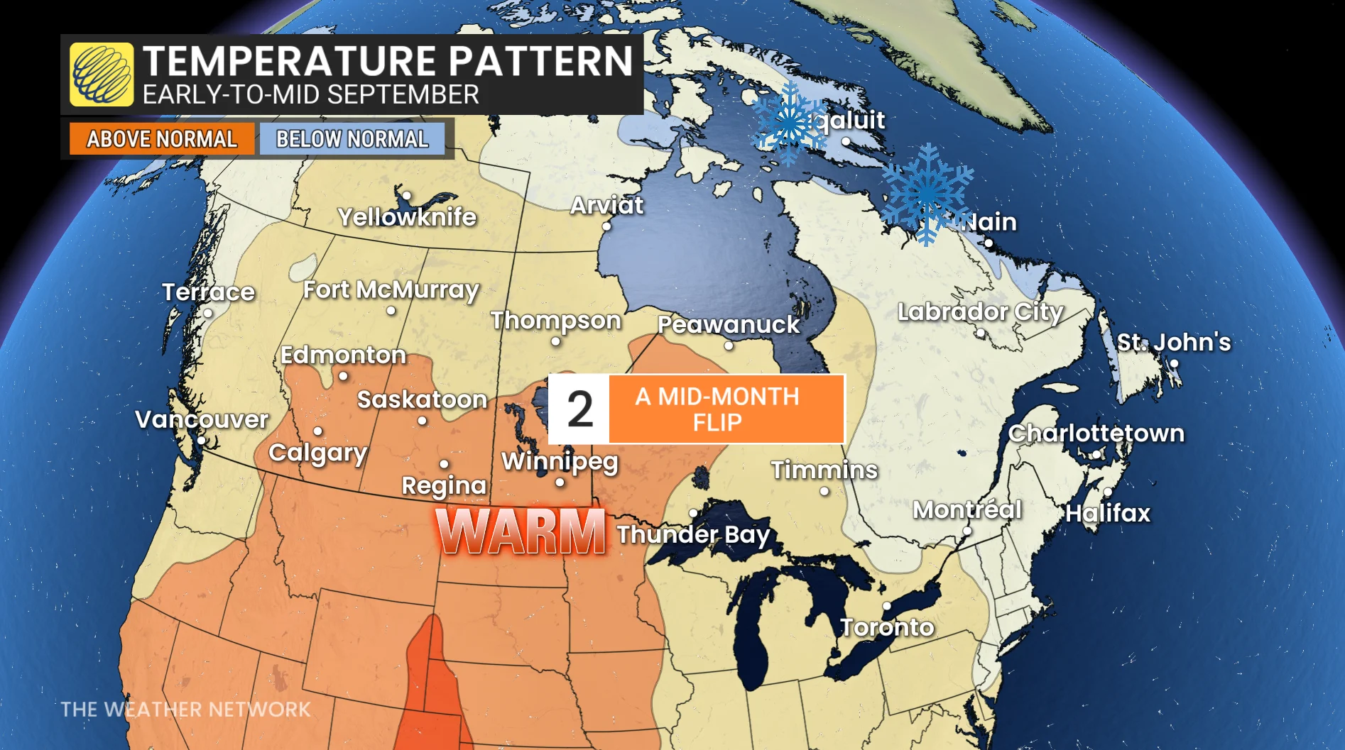
Lesson 2: A mid-month flip
By the second week, the West finally shares its notes with the rest of the class.
The extreme heat eases as it pushes eastward into the Prairies and northwestern Ontario, even stretching north into the Arctic.
Meanwhile, the Great Lakes to Atlantic Canada stay a few degrees cooler than normal, like a dreaded pop quiz. As the warmer air expands eastward, most of the country will be back in a late-summer comfort zone by mid-month, but southern Ontario and southern Quebec could struggle with their return to more consistent, late-summer weather.
DON’T MISS: What does a classic fall storm look like in your part of Canada?
Lesson 3: Grading on a curve
The second half of September offers a much kinder report card. A milder pattern is set to dominate most of Canada, with only brief cool interruptions. For Ontario and Quebec, the warm second half should balance out the early chill.
Remember, the seasonal temperature curve is always falling this time of year: "Normal" temperatures fall by 1°C-3°C per week, so even a near-normal day can feel chilly when compared to August.

Lesson 4: Participation marks for precipitation
Most of Canada will be near normal or drier than normal.
The B.C. coast may turn wetter in the final week, signalling the start of fall storm season
Atlantic Canada’s greatest rainfall threat comes from tropical systems--it only takes one to tip the totals above normal.

Lesson 5: Hurricane season homework
For Atlantic Canada, you have one assignment: Keep an eye on the tropics.
September is the peak of hurricane season, and history has delivered some of the strongest hurricanes this month: Juan (2003), Igor (2010), Dorian (2019), and Fiona (2022). They all struck Atlantic Canada in September, leaving lasting damage and unforgettable impacts.
It only takes one storm to define a season, and even one just brushing the coast can bring flooding rains and damaging winds.

The final grade
September 2025 will deliver a little bit of everything: Heat waves, frosty mornings, and even the first snowflakes, alongside plenty of bright spots and outdoor opportunities.
Whether you’re clinging to summer warmth or embracing the first pumpkin spice latte of the season, this month’s forecast has something on the syllabus for everyone.

With files from Dr. Doug Gillham, a meteorologist at The Weather Network.
Stay tuned to The Weather Network for the latest forecast updates for Canada as September progresses.