Race in Ontario to see final 30-degree day this year isn't over, yet
Have we finally seen the last of summer's 30°C heat in Ontario? Well, most likely not. An unusual heat wave in October brought us two readings of 30°C in southern Ontario on Saturday, and we have a good chance of seeing it happen again on Sunday.
A strong ridge of high pressure situated over the province has helped extend summer's heat across southern Ontario into the first several days of October. How many more 30-degree days could there be this year?
Well, we recorded another on Saturday, Oct. 4, a not-so-common feat at this time of the year. Two 30-degree temperatures were recorded, with Sarnia and Windsor airport registering values just over that mark. More communities saw readings approaching the 30-degree mark, setting monthly records in many cases.
SEE ALSO: Canada's October wild card: Record warmth on the table, but snow still in play
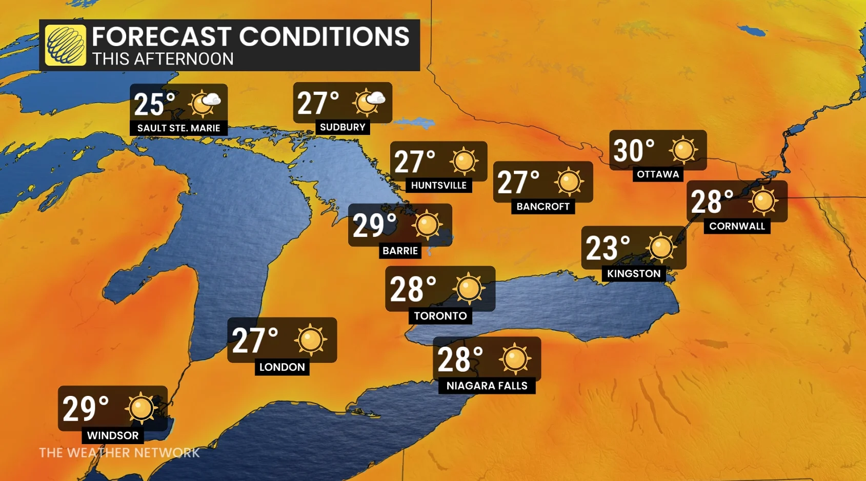
Sunday will offer yet another chance to record another a 30-degree reading in multiple locales in southern Ontario. So, that raises the question: When will summer's grand finale finally occur in southern Ontario?
Monthly records set. How long will the summer heat stick around across southern Ontario?
Monthly records were shattered across Ontario on Saturday, with more of them up for grabs on Sunday.

Exceptional and unprecedented heat is ongoing this weekend across Ontario as a large, high-pressure system drifts east across the region.
Top Ontario temperatures on Saturday
Sarnia: 30.8°C
Windsor airport: 30.4°C
Atikokan: 29.9°C
Hamilton: 29.7°C
Bancroft: 29.1°C
Brantford Municipal Airport: 29.0°C
Delhi: 29.0°C
London International Airport: 28.9°C
Muskoka Airport: 28.9°C

Close behind were Point Pelee at 28.9°C, Vineland station at 28.8°C and Wiarton airport at 28.7°C.
Communities like Atikokan, Sault Ste. Marie, Sudbury, and North Bay recorded their warmest temperatures in recorded history for October.
Several locations have a shot at hitting 30 on Sunday, including Windsor, Sarnia, Moosonee, Collingwood, Cornwall, Borden, Petawawa and Ottawa.
This isn't the first time we've had summer heat linger well into fall, however. Some cities across southern Ontario have had to wait a full week into October for the temperature to finally drop.
Latest 30-degree days in southern Ontario:
Windsor: Oct. 8, 2007 (31.9°C)
Toronto: Oct. 8, 2007 (31.6°C)
Hamilton: Oct. 8, 2007 (30.3°C)
London: Oct. 6, 1946 (30.0°C)
DON'T MISS: Canada ends September with its first -20°C reading of the season

Without the cool air and rainy days we know and love about fall, we will see drought conditions continue to get worse over the coming days.
Temperatures cool slightly on Monday in the south, but much more sharply across northern Ontario.
But we will see an end to the heat streak in the south this week.
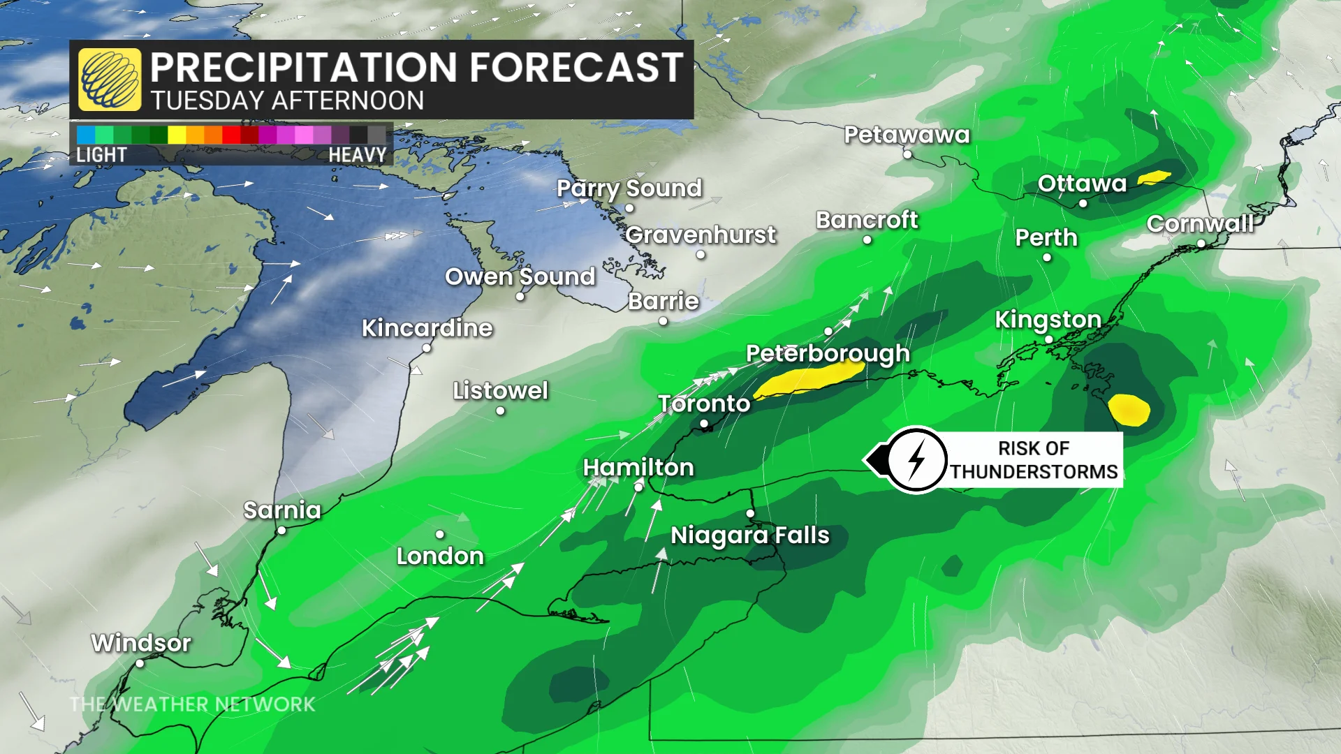
On Tuesday, conditions become unsettled across southern Ontario as the long-awaited cold front crosses the region. Some modest instability means there’s a risk for some thunderstorms through the morning and afternoon hours.
Wednesday and Thursday will be much colder, a rather abrupt transition to autumnal weather with highs in the low- to mid-teens. Areas north of the Greater Toronto Area (GTA) will struggle to reach the lower teens. Widespread frost is likely, especially outside of urban or suburban areas Thursday morning.
WATCH: Can Canada expect snow in October? Find out in our monthly weather outlook, below
Stay with The Weather Network for more information and updates on your weather across Ontario.