Prairie blizzard: Dangerous travel with heavy blowing snow and squalls
A powerful winter-like storm is ongoing across the Prairies, delivering heavy snowfall, strong wind gusts leading to blowing snow, and temperatures well below seasonal norms. These conditions are expected to persist through Saturday
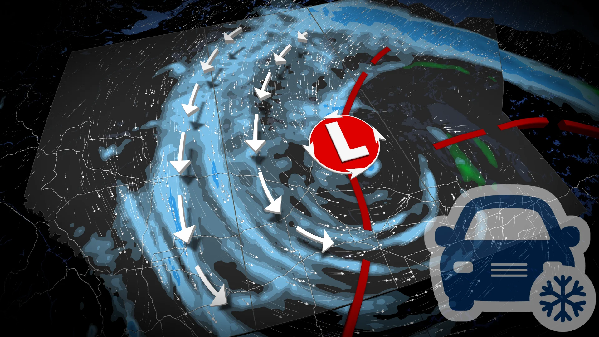
A powerful spring snowstorm sweeping across the Prairies will continue to disrupt travel from Alberta to Manitoba through Saturday.
Blizzard, winter storm, and snowfall warnings have been issued, as the storm will bring strong winds and significant snowfall, with some areas expected to see more than 50 cm of accumulation.
The system is forecast to retrograde westward into Saskatchewan, extending its impact before gradually weakening over the weekend.
DON'T MISS: Summer Sneak Peek: El Niño may split Canada’s summer in two
Weather Highlights:
Widespread snow on the southern Prairies with 20-50+ cm expected in the north
Strong winds will result in extensive, blowing snow and reduced visibility, especially on the Yellowhead Highway and along Highway 1 west of Saskatoon and Regina
The good news, at least, is that the precipitation is much-needed moisture as the region prepares for fire season
Travel disruptions and hazardous road conditions are likely, so plan accordingly and check local updates for the latest weather alerts.
Prairies face intense snowfall, strong winds, and whiteout conditions as wintry storm lingers
Snow and strong winds are affecting parts of the Prairies as a powerful storm system brings colder temperatures and challenging conditions. Atmospheric blocking is stalling the storm, causing it to retrograde westward and produce heavy snow bands.

Snow squalls are expected in areas near Edmonton, Cold Lake, and Prince Albert through Friday. These narrow, short-lived bursts of heavy snow could cause intense impacts in localized areas.
Snow amounts between 5-15 cm are possible, with higher accumulation in regions where intense squalls persist.
SEE ALSO: Strong winds and snowsqualls hit Alberta hard, outages, closures rack up
WATCH: Hazardous driving conditions in Alberta as blowing snow and strong winds hit
Snow squalls may intensify Friday morning, moving into Alberta and shifting through the day. Commuters along the QE2 corridor, including Calgary, could face reduced visibility and rapid snow accumulation, especially Friday afternoon and evening.

Wind gusts between 50-80 km/h will create blowing snow and whiteout conditions, with the strongest gusts expected in Alberta by Friday afternoon.
RELATED: What turns a snowstorm into a raging blizzard?
Meanwhile, in northern Saskatchewan and Manitoba, heavy snow will continue into Friday, tapering off Saturday. These areas could see an additional 20-30+ cm of snow.
An orange blizzard warning was issued for parts of central and northern Manitoba due to the severe blowing snow and reduced visibility.

Behind the storm, Arctic air is expected to plunge temperatures nearly 20°C below seasonal norms, adding to the wintry conditions.

Unseasonably cold temperatures to grip the Prairies into early May
Significantly colder-than-normal temperatures will persist across much of Alberta and Saskatchewan through the middle of next week.
Western regions of the Prairies may see a brief moderation later in the week, but eastern areas are expected to stay colder than normal through the first week of May. There is also potential for the chilly conditions to return to parts of Alberta at times.
Stay tuned to The Weather Network as we continue to update the forecast for the Prairies.