
Canadian landfall? Closely watching two scenarios with Hurricane Melissa
Atlantic Canada could experience impacts on Friday (Halloween) as a low pressure system over eastern Canada merges with Hurricane Melissa, directing moisture into the region. Damaging wind gusts are expected, which may lead to power outages and the potential for trick-or-treating cancellations or postponement. Homeowners are advised to secure any loose items.
Weather Highlights:
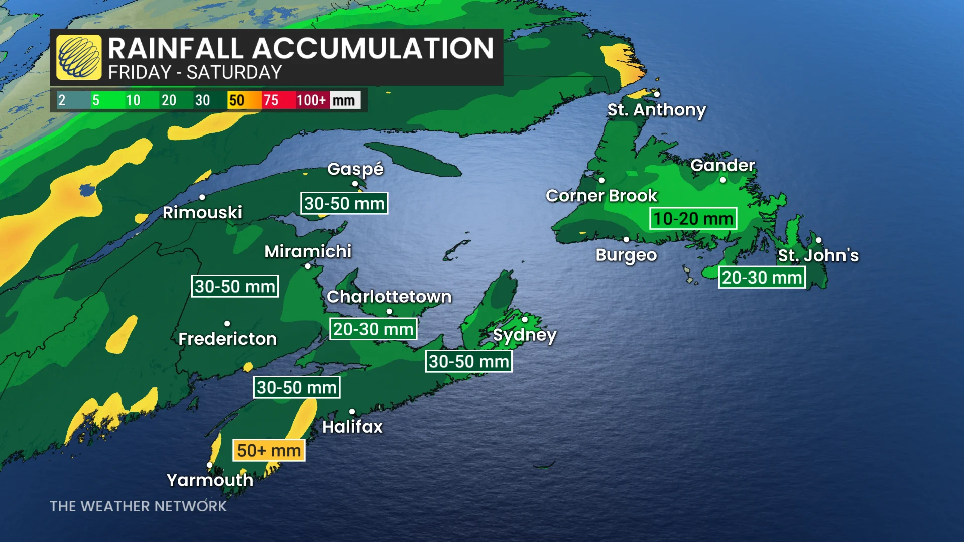
Melissa will enhance a low pressure system, bringing 30-50+ mm of rain to the Maritimes, with heaviest rainfall expected in Halifax by Friday afternoon
Winds of 50-70+ km/h are forecast Friday, with gusts of 60-90+ km/h and waves of 5-8 m off Nova Scotia and 3-5 m in the Bay of Fundy by Saturday, which could lead to some power outages
Melissa's wind field will expand as it nears Newfoundland. If offshore, wind gusts of 50-80 km/h could impact the Avalon Peninsula. If the storm tracks onshore, tropical-force winds of 100-130 km/h are possible Friday evening into Saturday, increasing risks of damage and outages
Hurricane Melissa made a second landfall in Cuba early Wednesday after causing record-breaking and devastating destruction in Jamaica. The storm is the strongest hurricane ever recorded on the island.
DON'T MISS: How a mammoth hurricane rapidly intensifies in mere hours
Melissa is accelerating northeastward and is forecast to pass northwest of Bermuda on Thursday before transitioning into a powerful post-tropical storm. As it merges with a fall storm tracking from the southeastern U.S. to the Gulf of St. Lawrence, it is expected to bring heavy rain from eastern Ontario to the Maritimes and Newfoundland.
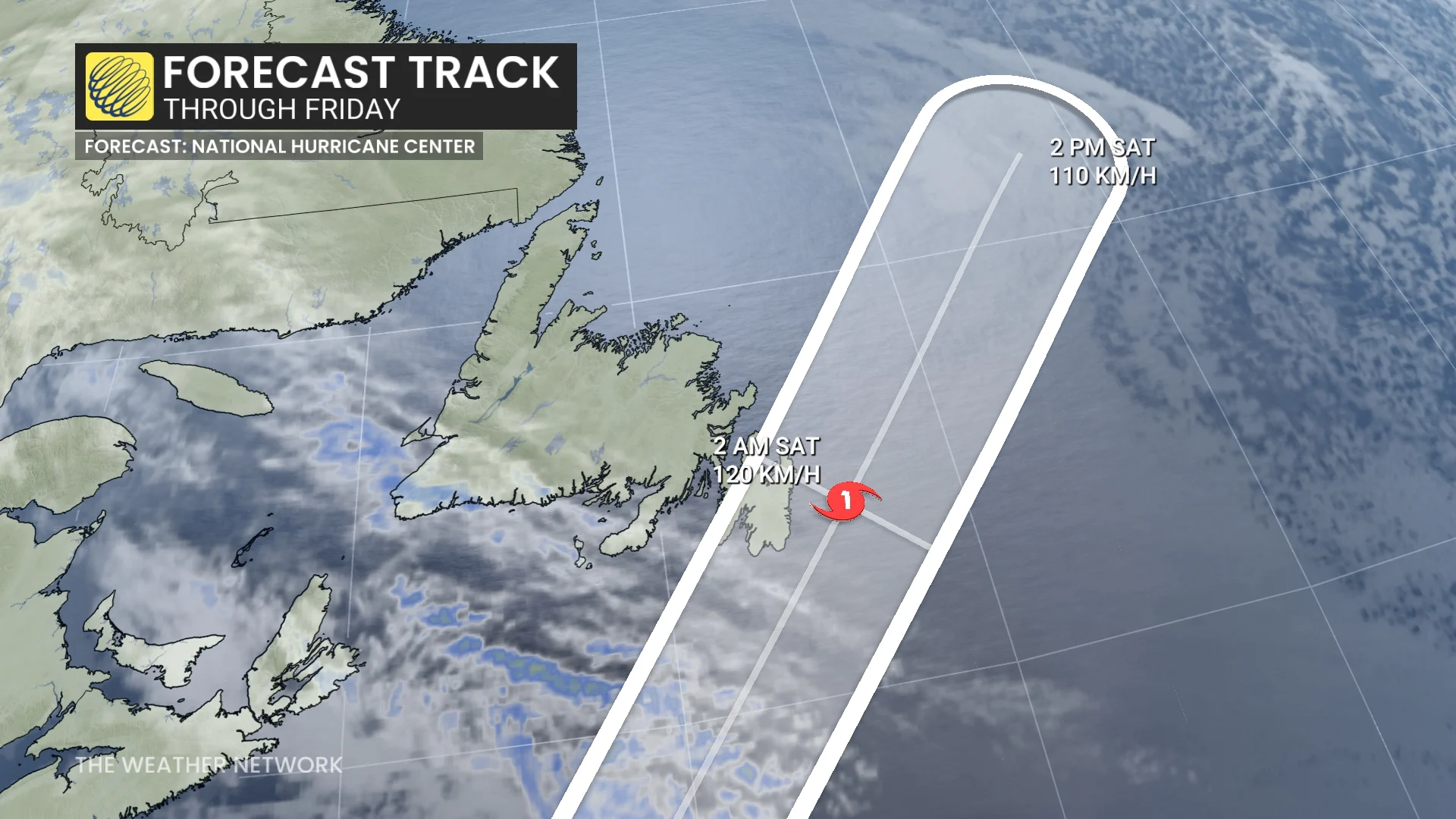
Uncertainty remains around the exact track of Melissa as it approaches eastern Newfoundland. However, it could bring significant wind gusts of 100-130 km/h to the Avalon region, potentially impacting areas such as St. John’s on Friday night.
Stay up-to-date with all hurricane developments on The Weather Network's tropical storm hub page
Forecast models have shifted the track of Melissa further west over the past day. The U.S. National Hurricane Center (NHC) also adjusted its forecast, keeping Melissa offshore for now, but changes remain possible.
Heavy rain picks up through the Maritimes on Friday (Halloween)
Offshore, Melissa will feed moisture to an onshore low pressure system, prompting widespread rain across the Maritimes.
Widespread rainfall amounts of 30-50+ mm are anticipated, with Halifax seeing heavier rainfall by Friday afternoon.
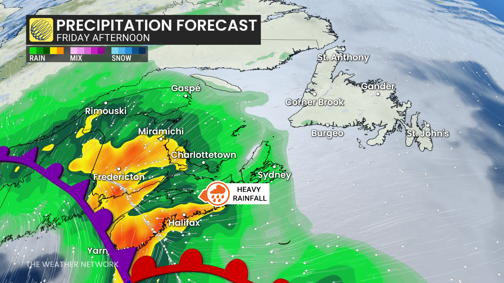
Rain will persist in the eastern Maritimes through Friday evening. Rainfall warnings are in effect for parts of southeastern Nova Scotia and New Brunswick.
"Clear storm drains and gutters of leaves and other debris prior to the rainfall to help reduce flooding," says Environment and Climate Change Canada (ECCC) in the warning.
Parents and trick-or-treaters are advised to monitor the forecast closely, as this system has potential to impact plans on Halloween. More on that in the video below.
WATCH: Postpone trick-or-treating? Atlantic Canada faces soggy dilemma
Winds of 50-70+ km/h are likely across the Maritimes by Friday. A northwest flow behind Melissa will maintain gusty conditions on Saturday, with winds reaching 60-90+ km/h.
Wave heights are expected to rise, reaching 5-8 m off the coast of Nova Scotia and 3-5 m in the Bay of Fundy.
Threat for outages with powerful winds in Newfoundland & Labrador: Two scenarios on the table
As Melissa travels toward Newfoundland, its wind field will expand, though there’s uncertainty around the storm’s exact path. The U.S. National Hurricane Center forecasts the storm to become an extra-tropical hurricane as it nears Canadian waters.
SEE ALSO: What does a hurricane's ‘cone of uncertainty’ mean?
Upon approach, the system is expected to be asymmetrical, with the strongest winds and impacts occurring to the right of the centre. The most significant impacts would occur if the storm makes its fourth landfall in Newfoundland.

One scenario keeps Melissa offshore with 50-80 km/h winds for eastern Avalon, while another model tracks Melissa directly over Avalon, potentially bringing damaging winds of 100-130 km/h Friday evening into Saturday.

It will be important to stay up-to-date for further developments on Melissa’s track and impacts.