Incoming storm threatens more ice, flooding rains, and big April snow in Ontario
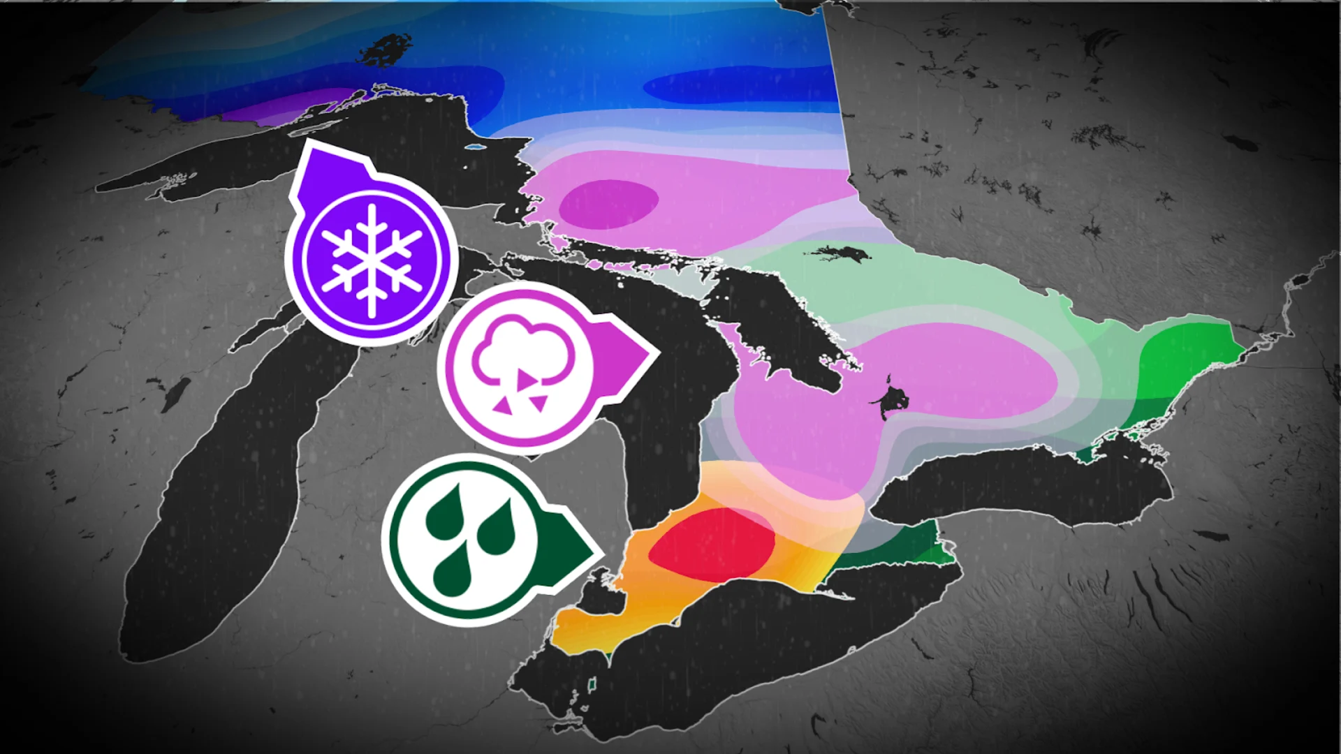
Special weather statements are in effect for the next moisture-packed system that will bring more freezing rain, and the threat for localized flooding to southern Ontario. In the north, as much as 20+ cm of snow could fall. Stay alert to the changing conditions in your area through Thursday
Hot on the heels of Ontario's damaging weekend ice storm, another icy system is making its way to the province for Wednesday.
PHOTOS: Ontario ice storm causes widespread damage, outages
There's another risk for freezing rain with the incoming system, but luckily this storm will not be like the last. A relatively quick changeover to rain will prevent a repeat ice storm, with ice accretion expected to be mostly less than 5 mm.
Significant rainfall will follow however, which presents the risk for localized flooding. Upwards of 50 mm could fall in some of the hardest-hit areas, with strong thunderstorm chances creeping into the southwest, as well. To the north, on the cold side of the storm, there's the potential for more heavy snow to fall through Thursday. Travel conditions will be treacherous.
Hardest-hit regions in for another icy smack on Wednesday
A Colorado low moving into the Great Lakes region on Wednesday will once again bring all the precipitation spring has to offer to Ontario. Luckily, this will be a much shorter-lived event than the ice storm over this past weekend—beginning Wednesday afternoon and moving out of the province by Thursday morning.

Cities and towns still cleaning up from the weekend's ice storm, such as Barrie, Orillia, Peterborough, Bancroft, and Kingston, will once again be the unlucky targets for this next icy blast.
The silver lining will be the fact that this is a much faster-moving storm, only bringing 2-8 hours of freezing rain the region instead of the 20-35 hours over the weekend.

The shorter duration will also limit ice accretion to 2-5 mm—still enough to make roadways and sidewalks dangerous, but not nearly as damaging as the 5-30 mm from the weekend.
DON'T MISS: Get to know the hidden gems across Canada
Winds gusting to 50-70 km/h will also serve to limit ice accretion, but could lead to an increase in localized power outages.

As of Tuesday morning, Hydro One reported that 275,000+ customers were still without power from the weekend. Crews have restored power to more than 637,000 homes and businesses since the start of the storm.
"Given the severity and widespread damage caused by this storm, we expect restoration in the hardest hit areas to continue throughout the week. For remote areas, restoration may take longer," Hydro One stated on their website.
Road access continues to be a challenge in hardest-hit areas, as well, along with safety concerns of trees and tree limbs coming down.
Heightened flood threat with heavy downpours and thunderstorms across southern Ontario
To the south, we're looking at heavy rains and thunderstorms on Wednesday, with 30-60+ mm of rain on tap—rivalling some of April's wettest days in the region.
DON'T MISS: Severe thunderstorm threat over southern Ontario with risk of damaging winds
There is also a risk for some of the storms to reach severe criteria, with strong winds and downpours as the main threats.

The Grand River Conservation Authority (GRCA) issued a flood warning on Monday following the heavy weekend rain, with river flows remaining elevated as runoff from rain and any remaining snow melt drains through the river system.
MONTHLY OUTLOOK: April’s wild side will show its true colours across Canada
The rain will end from west to east Wednesday night, and into early Thursday morning.
More heavy snow blasts northern Ontario
Meanwhile, northwestern Ontario will stay on the colder side of the system, with the Thunder Bay area forecast to receive 20-30 cm of early April snow.

A winter storm watch is in effect for the region, with peak snowfall rates of 3 to 5 cm per hour expected at times. Reduced visibility in heavy and blowing snow could make for some dangerous travel conditions into Thursday. Drivers are urged to avoid any non-essential travel until conditions improve.
Be sure to check back for the latest weather updates across Ontario.