
October storms may bring coldest temperatures since May to southern Ontario
A cold front advancing across Ontario on Tuesday could reach severe thresholds as it moves through, bringing an abrupt end to the recent heat
Southern Ontario experienced summer-like weather this weekend, with highs in the mid to upper 20s, typical of mid-July. Monday looks to continue this trend, with widespread sunshine and temperatures reaching the upper 20s, possibly touching 30°C in some areas.
SEE ALSO: Canada's October wild card: Record warmth on the table, but snow still in play
A strong cold front is expected to then move across the region on Tuesday. Early in the day, temperatures will remain warmer than seasonal, particularly in southern areas. However, as the front pushes through, temperatures will gradually drop. A few hours of rain are expected along and ahead of the front, with a chance of thunderstorms.
By Wednesday and Thursday, the weather will make an abrupt shift to autumn territory. Some areas north of the Greater Toronto Area (GTA) will struggle to hit 10–12°C. Frost is likely Thursday morning, especially in rural and suburban areas, marking a notable transition from this weekend’s warmth.
October thunderstorms threaten the day on Tuesday, brace for slower commutes
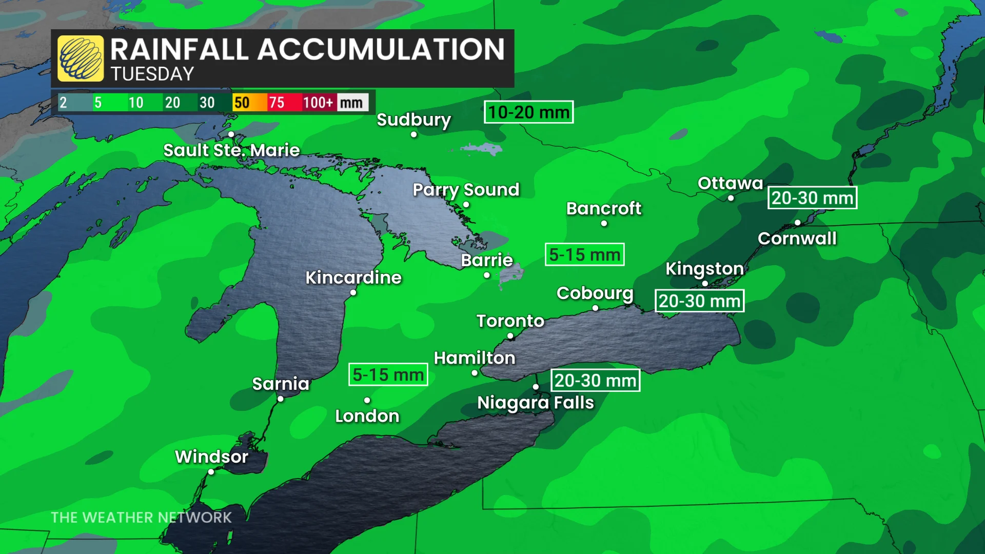
Following a record-breaking warm October weekend, a strong cold front is set to bring colder weather and significant rainfall to southern Ontario. The sharp temperature shift will fuel thunderstorms along the cold front, impacting different regions at various times.

For southern Ontario, thunderstorms are expected overnight Monday into Tuesday afternoon. Eastern Ontario will see storm activity from Tuesday morning into the afternoon hours.
The Niagara Peninsula faces the highest risk of heavy rain and localized flooding, with 20–30+ mm of rain possible under thunderstorms. Areas like the GTA are likely to receive 5–15 mm.

While the risk for severe thunderstorms remains low, isolated strong storms may develop, particularly late Tuesday afternoon.
Slower commutes are likely due to rain and wet road conditions on Tuesday morning and evening.
Cooler weather takes hold starting Wednesday
A colder air mass will settle over Ontario by Wednesday, bringing seasonal October temperatures in the low to mid-teens for the rest of the week.
Morning temperatures will feel especially chilly, so plan to dress in layers starting mid-week.
DON'T MISS: Canada ends September with its first -20°C reading of the season
Thursday’s forecast high of 12°C in Toronto would mark the city's coldest daytime high since May 22, a span of 137 days! Stay prepared for cooler mornings and autumn-like conditions ahead.

Temperatures are expected to rebound slightly by Friday and through the Thanksgiving long weekend, with the possibility of a warm day or two that could reach the low 20s.
Looking ahead, the latter half of October is expected to trend closer to seasonal averages compared to the unusually warm start of the month. Even so, temperatures are forecast to remain somewhat above normal overall.
WATCH: Can Canada expect snow in October? Find out in our monthly weather outlook, below
Stay with The Weather Network for more information and updates on your weather across Ontario.