Canada’s November features extended fall, but winter lurks on the sidelines
November will start with extended fall across most of Canada, but a major pattern change lurks around the end of the month
November has a history of turning into a wintry month across much of Canada, bringing cold temperatures and snowy conditions from coast to coast.
Thankfully, the month ahead looks to buck that trend—at least to start. We’re looking forward to extended fall conditions across much of the country for the majority of November.
But keep an eye out for a rapid pattern flip by the end of the month, one that could allow an abrupt switch to wintry conditions to spill across much of the country.
DON’T MISS: Snowy surprises can blanket Canada during a typical November
October’s mild weather continues to start November
October finished as a warmer-than-normal month for just about all of Canada except for British Columbia.

The pattern that produced those above-seasonal conditions looks to continue heading into the first half of November.

RELATED: The end of Daylight Saving Time affects sunsets, sleep, safety
Forecasters expect that warmer-than-normal temperatures will cover a large swath of the country from the B.C. Interior eastward across the Prairies and into northern Ontario as we move into early November.
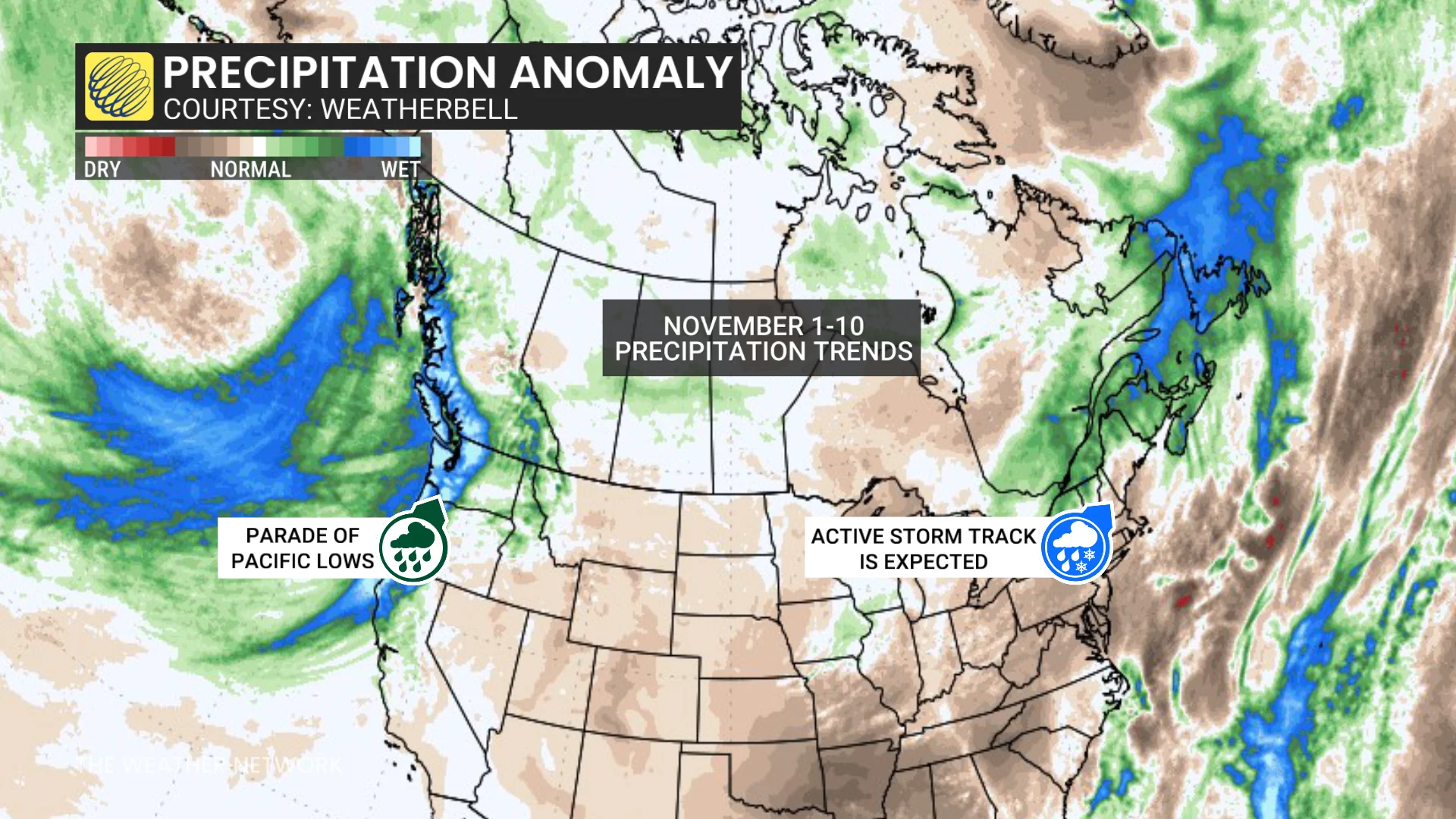
A more active storm track is expected in November than we saw earlier in the season, with more opportunities for precipitation spreading from coast to coast. It’s likely that the B.C. coast and Atlantic Canada will be the primary targets for fall storms throughout the month.
As a result, folks across portions of southern and northeastern Ontario, as well as the northern half of Quebec, can expect near-seasonal conditions to kick off the month.
Meanwhile, below-seasonal conditions are favoured throughout Atlantic Canada, southern Quebec, and into eastern Ontario.

MUST SEE: Autumn can still produce intense hurricanes across the Atlantic
As November continues, above-seasonal temperatures will spread east, with mild conditions expected into southern Ontario and southern Quebec. Only B.C. and the East Coast are expected to have near-seasonal conditions through the middle and latter half of the month.
However, a big change is on the way towards the end of the month as we make an abrupt transition into early winter.
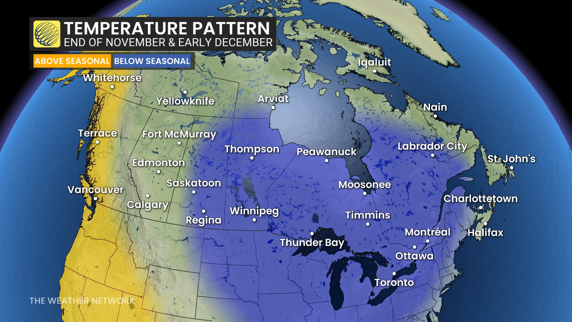
While the precise timing of this pattern flip remains uncertain, forecasters are eyeing the potential for widespread below-seasonal temperatures to spill across the eastern two-thirds of Canada during the final days of November and into December.
This dive into winter-like weather will spread from the central Prairies east into the Maritimes, bringing these areas colder temperatures—and the likelihood for frozen precipitation.
Snow starts to creep south in a normal November
Snow isn’t uncommon across Canada during an average November.

Most major cities from Calgary to St. John’s typically pick up double-digit snowfall totals during the month—not always all at once, of course, but a few coatings here and there can add up in a hurry.
November is usually the kickoff of lake-effect snow season downwind of the Great Lakes. When all the right conditions align, powerful snow squalls whipping off the lakes can bury nearby communities in a flash.