
Moisture-packed low brings some much-needed rain to Atlantic Canada
Atlantic Canada set to receive more rain than the past 55 days combined.
Atlantic Canada is set to receive some much-needed rainfall later this week. Rain will move into the Maritimes Thursday night, lingering into Friday across Nova Scotia and P.E.I. It will also spread to Newfoundland on Friday, continuing into Friday night across the Avalon Peninsula.
DON'T MISS: What’s the wettest month in your corner of Canada?
While Friday’s rainfall won’t fully end the ongoing drought, it will provide the first significant impact in two months.

Many areas in the Maritimes and southern Newfoundland are expected to see 15-30+ mm, with some pockets of locally heavier rain.
Wettest stretch of weather in two months
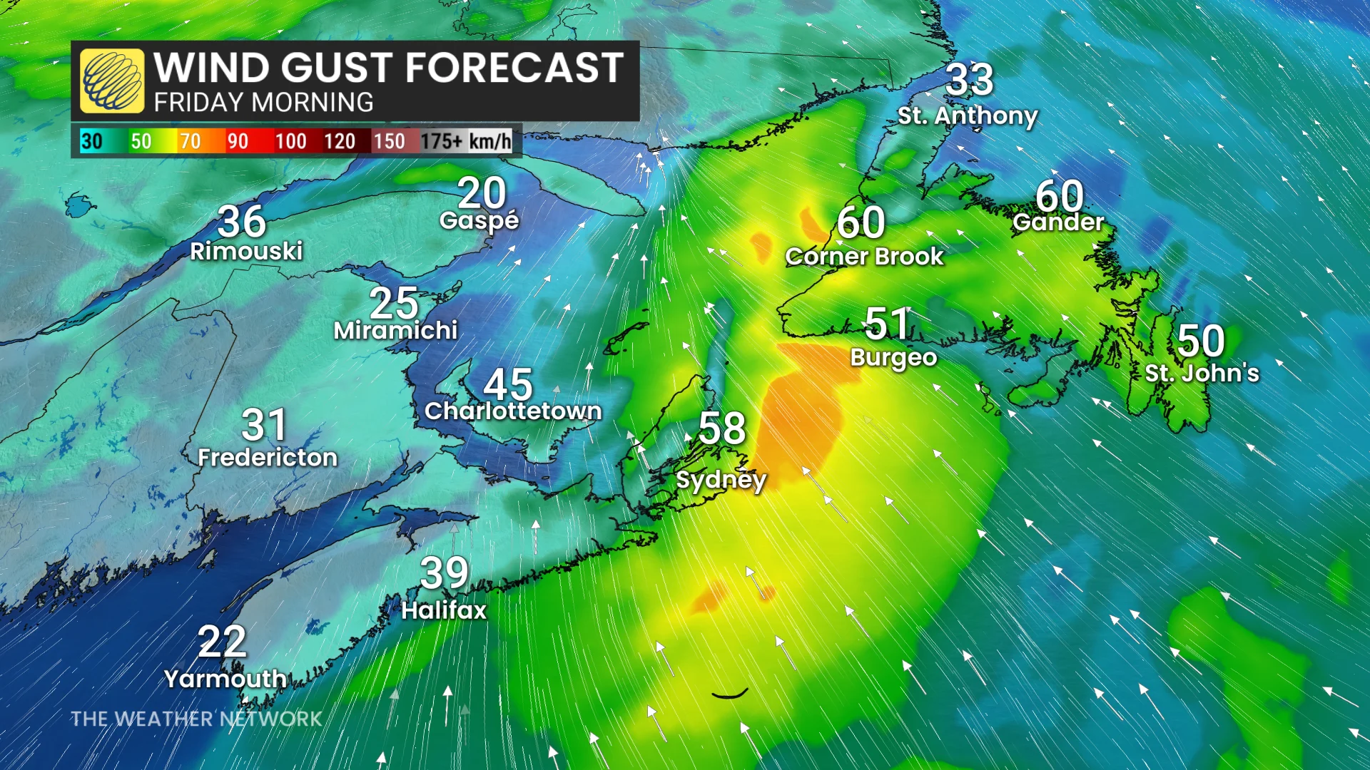
A fast-moving, moisture-rich low pressure system will arrive in the Maritimes Thursday evening, with most rainfall wrapping up by Friday morning as it spreads into Newfoundland and Labrador.

Southern and central New Brunswick may receive more rain in the next 24 hours than they have over the past eight weeks. Nova Scotia will miss the heaviest rainfall, though most areas are expected to see 10 to 20 mm.
Visit our Complete Guide to Fall 2025 for an in depth look at the Fall Forecast, tips to plan for it and much more!
The southern shore of Newfoundland will bear the brunt of Friday's rainfall; however, 10 to 20 mm is forecast for drier regions from St. John’s to Gander.

Wind warnings are in effect for Wreckhouse and Les Suêtes regions Friday morning into the afternoon, with gusts expected to reach up to 100 km/h.
Keeping a close eye on the Atlantic hurricane season for early October
A much drier weather pattern is anticipated to develop in early October, however, attention will turn to the increasingly active tropics. While current projections suggest storms will remain offshore, any shift to a more northerly track could alter the dry outlook.
SEE ALSO: Autumn can still produce intense hurricanes across the Atlantic
Temperatures are expected to remain near or above seasonal averages this weekend and into early next week. However, a brief cooldown midweek will bring highs a few degrees below seasonal norms, with single-digit highs possible for much of Newfoundland for one to two days.
Warmer conditions are forecast to return late in the week or into the weekend, though Newfoundland is expected to remain cooler for a longer period.
WATCH: What's the best month for rainboots in your town?
Be sure to check back for the latest weather updates across Atlantic Canada