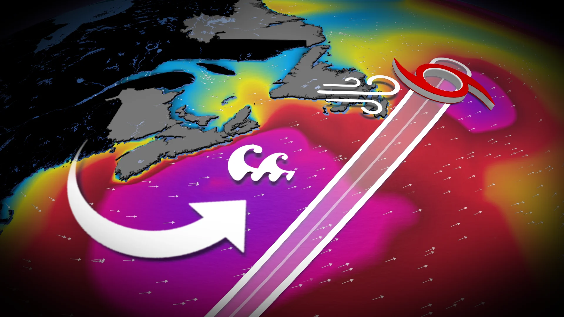
Melissa set to reach Newfoundland waters with large waves and powerful winds
On the forecast track, the centre of Melissa is projected to move south of the Avalon Peninsula in Newfoundland on Friday night as a post-tropical cyclone. Residents should prepare for periods of heavy rainfall, strong winds, and high surf conditions in the affected areas
Weather Highlights
Hurricane Melissa is expected to transition to a post-tropical cyclone on Friday and pass south of Newfoundland’s Avalon Peninsula on Friday evening into Saturday
The primary impacts of heavy rain and strong winds are expected to remain over the water on the east side of the storm
Wind gusts ranging from 70–90+ km/h are still anticipated for the far eastern edge of the Avalon Peninsula
Rough seas are expected across the East Coast as the storm passes the region
Heavy rain and gusty winds as Melissa tracks south of the Avalon Peninsula Friday
After devastating parts of Jamaica on Wednesday, Hurricane Melissa is moving quickly away from Bermuda and is expected to become an extratropical cyclone later on Friday. This transition means that the hurricane will be fuelled by upper-level winds rather than thunderstorms around the centre of the storm.
The latest models show Melissa remaining offshore of the Avalon Peninsula from Friday night into Saturday morning, but a period of heavy rain, strong winds and heavy surf are still expected.
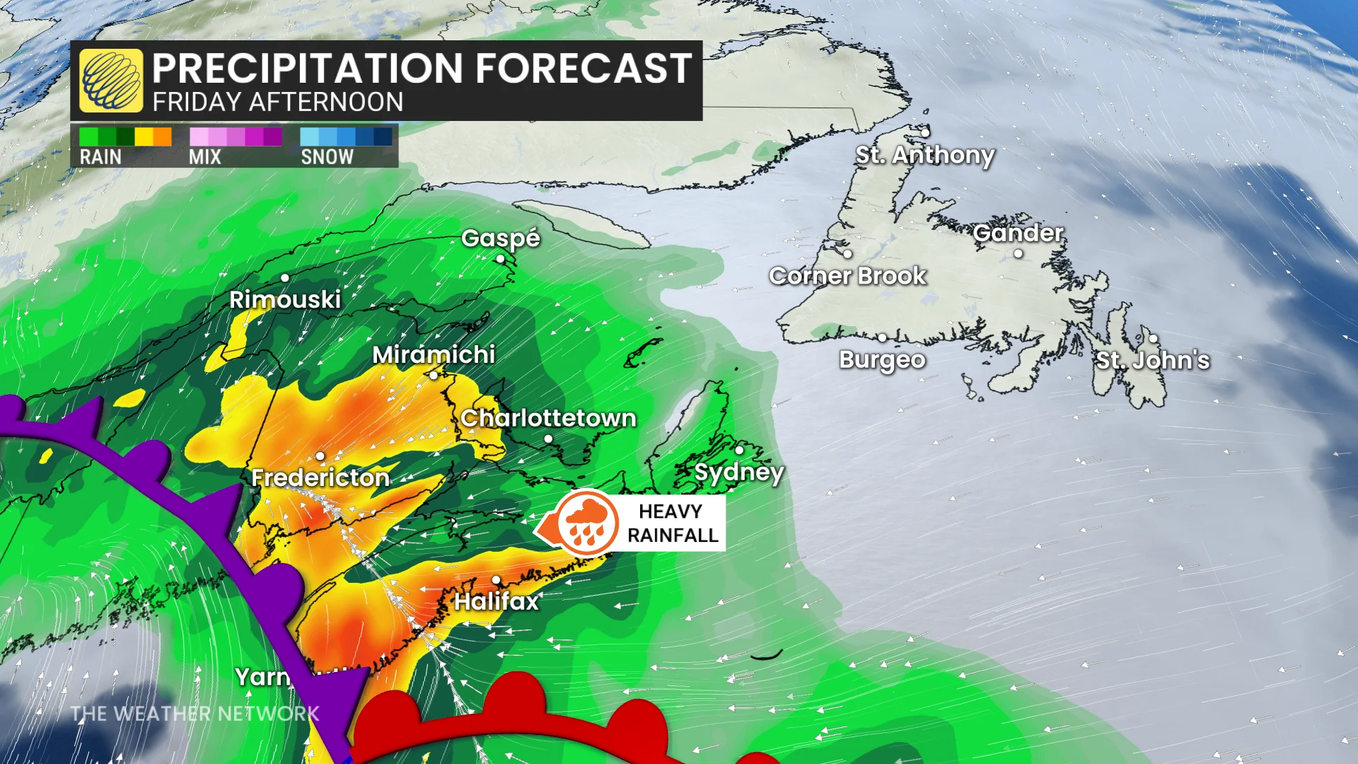
Heavy rainfall, fuelled by moisture from Melissa interacting with an onshore low pressure system, is expected to deliver widespread totals of 30-50+ mm across the Maritimes on Friday. The heaviest rain will impact Halifax, N.S. on Friday afternoon and continuing in the eastern Maritimes by evening.
Rainfall warnings remain active along the southeast coast of Nova Scotia and New Brunswick.
"Clear storm drains and gutters of leaves and other debris prior to the rainfall to help reduce flooding," says Environment and Climate Change Canada (ECCC) in the warning.

Friday evening will also see rising wave heights along George's Bank, with waves reaching 5–8 metres off the Nova Scotia coast and 3–5 metres in the Bay of Fundy.
Wind speeds between 50–70+ km/h could rise with Melissa’s weakening, leading to expanded wind fields. Saturday will bring gusty conditions driven by a northwest flow, with winds reaching 60–90+ km/h and creating choppy waters.
WATCH: Postpone trick-or-treating? Atlantic Canada faces soggy dilemma
For Newfoundland, the main impacts of Melissa’s heavy rain and winds will trend offshore. If it ends up tracking further west, however, heavy rain and stronger winds may be felt for parts of the Avalon.
The far eastern Avalon Peninsula is expected to see wind gusts of 70–90+ km/h overnight Friday into Saturday. Strong southwest winds will also persist across the region on Saturday.

Southeastern Newfoundland can expect large waves to build from the southwest late Friday evening, peaking early Saturday. Significant breaking wave heights are forecast to reach 5 to 7 metres during this period.
"These waves combined with the possibility of storm surge may cause higher than normal water levels particularly along southwest-facing shorelines in the Burin and Avalon Peninsulas beginning late overnight tonight and continuing into Sunday morning," warns the Canadian Hurricane Centre.

It will be important to stay up-to-date for further developments on Melissa’s track and impacts.