Massive in size and power, Category 4 Hurricane Erin threatens dangerous surf
Parts of North Carolina's Outer Banks have been placed under a tropical storm and storm surge watch as the still-growing, powerful, major Hurricane Erin begins a northward turn Tuesday that could send hazardous surf, rip currents and conditions towards the U.S. coast
While its winds are down from Saturday’s peak as a scale-topping Category 5, Hurricane Erin has grown in size and is maintaining its powerful status as a major storm.
Anyone visiting The Bahamas, Bermuda, the U.S. East Coast, and residents across Atlantic Canada, should closely monitor the track of this system this week. Rough seas and rip currents will extend far away from Erin’s path. In fact, its largest, single wave could reach as high as 30.5 metres (100 feet)--the size of a 10-storey building.
DON’T MISS: An inside look at Hurricane Erin’s astounding rise to Category 5

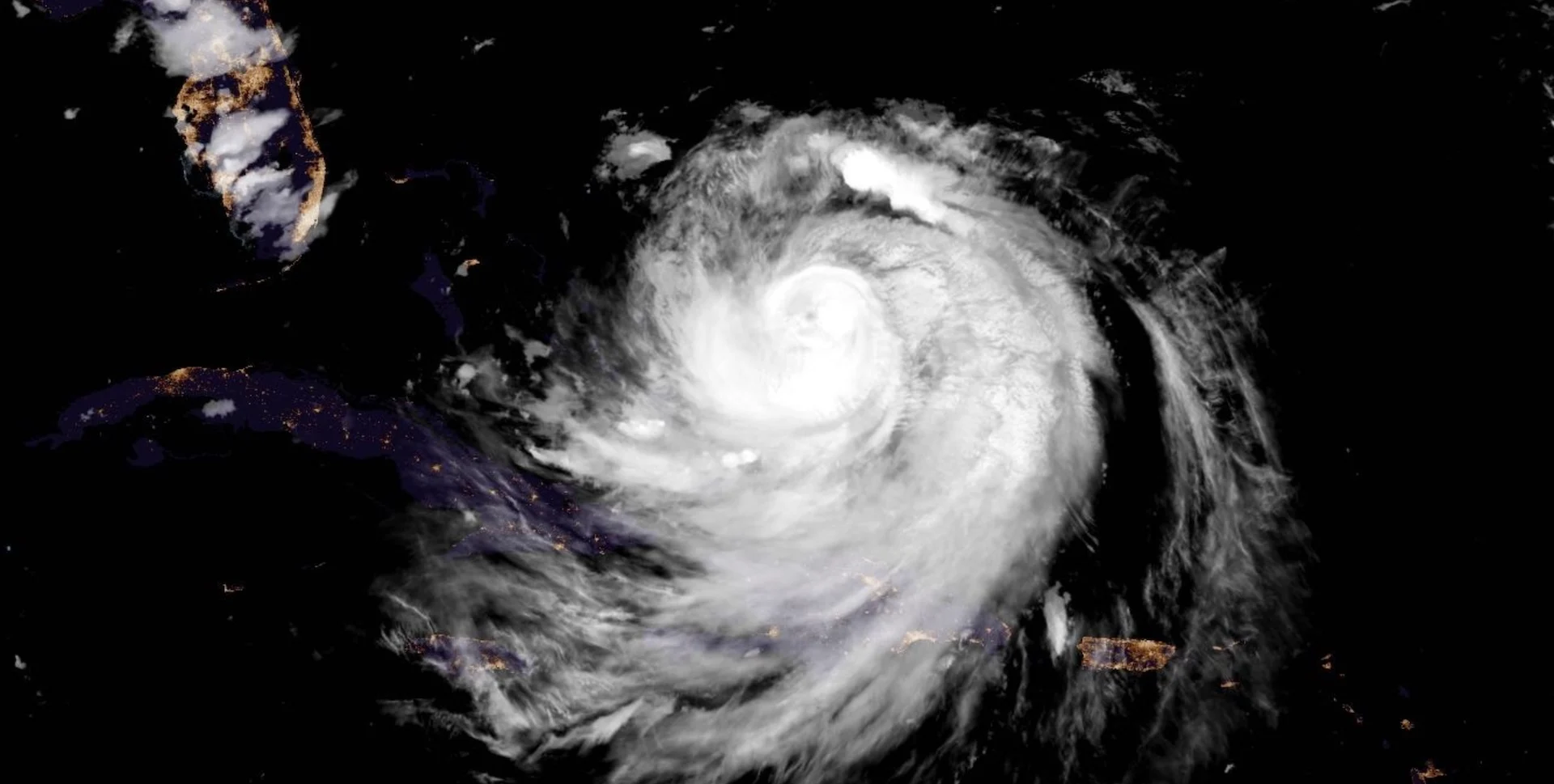
Aug. 16, 2025 satellite imagery of Hurricane Erin. (NOAA/CIRA)
A tropical storm and storm surge watch has now been issued for parts of North Carolina's Outer Banks. Tropical storm conditions are possible over portions of the Outer Banks beginning on Wednesday.
Erin still a major hurricane
Saturday’s astonishing bout of rapid intensification made Hurricane Erin the fifth Category 5 storm we’ve seen in the Atlantic since 2022.

The storm spent about nine hours with peak intensity of 260 km/h winds before winds slackened a bit as an eye-wall replacement cycle began.
Maximum, sustained winds have decreased slightly to near 210 km/h with higher gusts. However, the NOAA's Hurricane Hunters are currently investigating the storm. Erin is a Category 4 hurricane. Erin is likely to remain a dangerous, major hurricane through the middle of this week.

On the forecast track, the core of Erin is expected to pass to the east of the southeastern and central Bahamas Monday night, and move between Bermuda and the east coast of the United States by the middle of the week.
Further strengthening unlikely. Alerts issued in North Carolina
Monday evening, some dry air was intruding into the northwestern side of the storm, with northerly shear restricting some storm outflow. The result is a more disorganized look on satellite imagery.
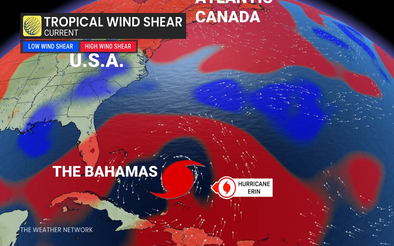
The storm is still a very large Category 4 storm that has impacts far removed from the centre. Further strengthening is unlikely, though, with some shear and dry air being the limiting factor.
Currently, hurricane-force winds extend outward up to 130 km from the centre, and tropical-storm-force winds extend outward up to 370 kilometres.
SEE ALSO: La Niña watch issued for this winter as key factors signal change
A ridge of high pressure over the Central Atlantic will force Erin to slowly recurve as it heads north through this week, avoiding a direct landfall in the U.S. or Bermuda.
The hurricane’s outer bands are affecting islands in the southwestern Atlantic, prompting tropical storm warnings for the Turks and Caicos Islands, as well as the southeastern Bahamas.
Meanwhile, alerts have been issued for parts of North Carolina's Outer Coast. A storm surge watch is in effect for Cape Lookout to Duck, N.C., and a tropical storm watch is in place for Beaufort Inlet to Duck, N.C., including Pamlico Sound.
Tropical storm conditions are possible over portions of the North Carolina Outer Banks beginning late Wednesday.
Additionally, flooding rains and gusty winds are occurring over portions of Hispaniola, and will do so through Tuesday for the Turks and Caicos, southeastern Bahamas, and the easternmost, central Bahamas. Localized flooding, along with landslides or mudslides, are possible.
Any hurricane recurving close to North America warrants close monitoring in Atlantic Canada.
Rip currents a major hazard
Regardless of Erin's track, rough surf and rip currents will pose a significant hazard to beaches throughout The Bahamas, Bermuda, eastern U.S. and Atlantic Canada during the early and middle part of this week.
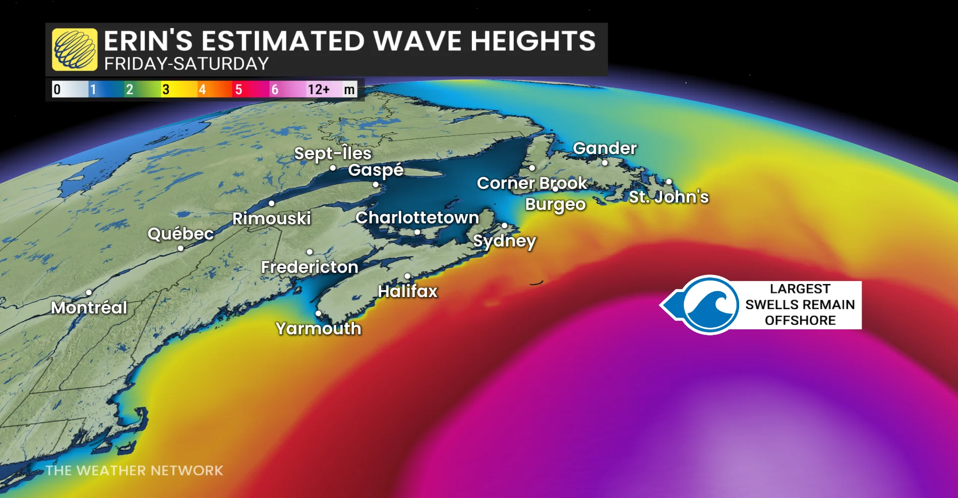
Impacts are still expected far beyond the core, with surf, rip currents and coastal flooding. Even with slight weakening in wind speed, the impact footprint is increasing.
Rip currents form when waves hit the beach head-on, creating narrow currents of water that rush back out to sea.

STAY SAFE: Rip currents are a natural hazard along coasts – here’s how to spot them
WATCH: What steers a hurricane?
Always heed the advice and orders of local officials and stay out of the water if there’s a threat for rip currents. Don’t panic if you’re ever caught in a rip current. If you can’t swim, calmly signal for help and tread water until assistance arrives. Swimmers should swim parallel to the beach until you’re out of the rip current, then swim back to shore.
Thumbnail courtesy of NOAA.