Canada to see March madness as winter transitions to spring

An active storm track and changeable temperatures could make for a messy March across much of Canada
Classic Canadian winter weather showed up in dramatic fashion across the country during February with record snowfall and severe cold for many areas.
This past month has been such a stark contrast to last winter when February felt more like spring across Canada.
DON’T MISS: Historic snow: GTA, Hamilton sees deepest snowpack in decades
Canada's flip-flopping February
Here is a look at the temperature anomalies that we saw across North America during the first three weeks of February. The various shades of blue, green, and purple highlight the colder-than-normal temperatures which were widespread across Southern Canada.

However, the final week of February has featured a dramatic pattern reversal as the entire country has experienced a taste of early spring.
The various shades of orange and red on the map below highlight the warmer-than-normal temperatures which have spread from coast to coast.

So is that it? Is winter over? Or is it just reloading for its grand finale? To find out, please read on for a look at what we expect during the month of March.
Changeable March temperatures likely
March is known for its periods of changeable and turbulent weather, and this year will reinforce that reputation.
The month will actually come in like a lamb across Western Canada as mild conditions will continue to dominate. However, the first 10 days of March will feature a temperature roller-coaster from the Great Lakes to Atlantic Canada, with alternating periods of wintry and spring-like weather.
Here is a model forecast which illustrates the dominant pattern that we expect for the first 10 days of March.

RELATED: Spring’s arrival and time change: March marks new beginnings
However, even for the areas where temperatures are forecast to be colder than normal, there will be a few mild days, and even significant rain across southern areas.
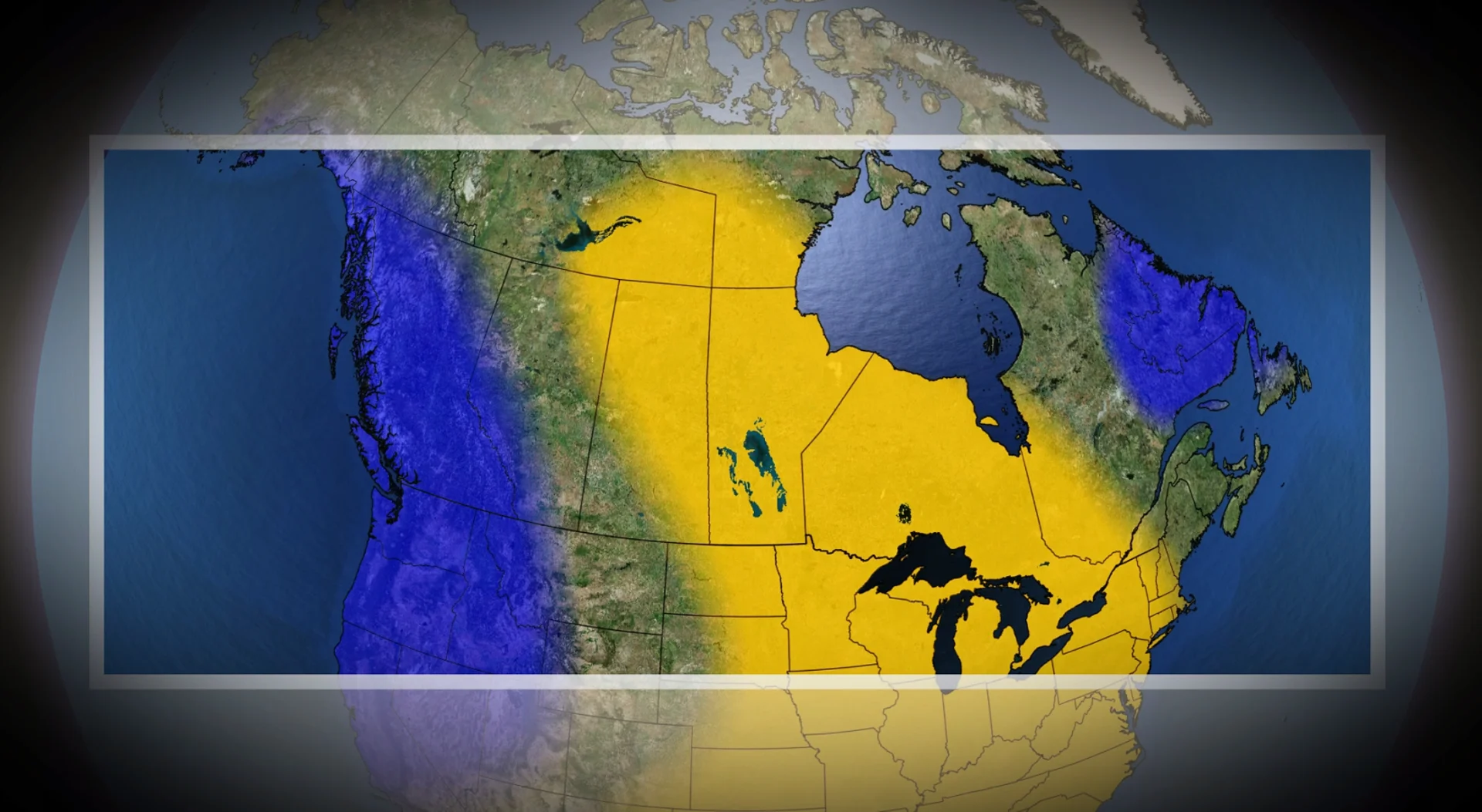
As we head into mid-March, we expect a shift in the national weather pattern. Here is the temperature pattern that we expect will dominate during mid- and late March.

While all of Canada will continue to see changeable conditions, above-seasonal temperatures should dominate for a couple of weeks from the central Prairies to western and southern Quebec, including the Great Lakes region.
Meanwhile, temperatures are expected to be near normal or tip to the cold side of normal across much of Western Canada and Atlantic Canada.
There are some indications that the mild pattern for Central Canada will break down before we close out the month, but it is too soon to make a call on how quickly that will occur. But, another pattern change at the end of the month wouldn’t come as a surprise during a season when frequent changes in the weather should be expected.
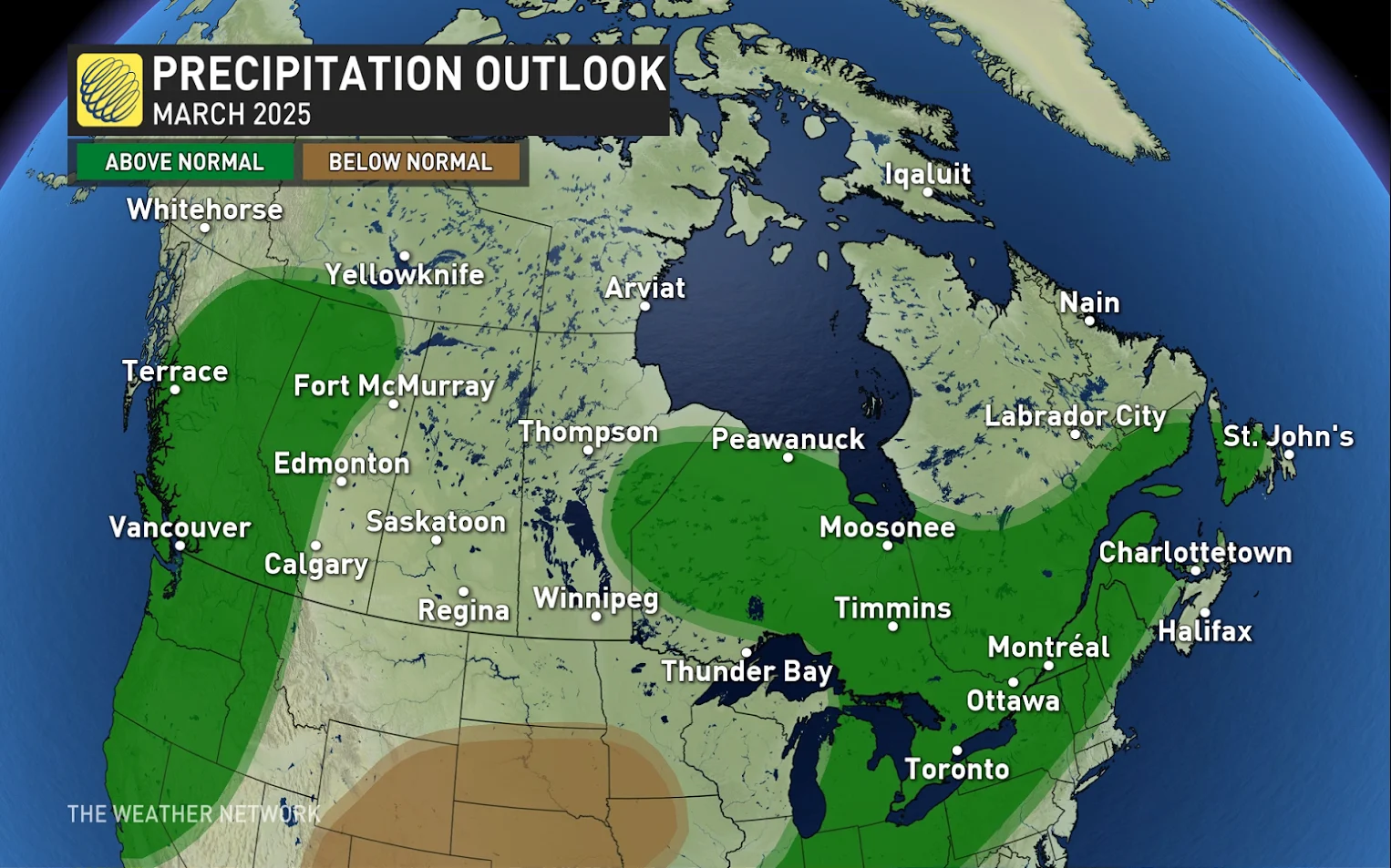
Active pattern could bring stormy weather
The changeable temperatures of March are often accompanied by stormy weather, which can include high-impact and messy winter storms, and also spring-like storms with heavy rain and a risk for flooding due to snowmelt and the frozen ground.
This year, we expect near-normal or above-normal precipitation totals for the month. The most active storm tracks are expected to stretch from the Great Lakes region to Atlantic Canada, as well as into B.C. from the northwest Pacific Ocean.
RELATED: Great Lakes have the most ice in years amid prolonged cold spell
Across Western Canada, the transition to a colder pattern and a more active storm track for mid and late March is great news for western ski areas. This pattern should bring an abundance of snow to the alpine region and allow for a more extended spring ski season.
What can we expect for the rest of spring? Please check back on March 13 for our spring forecast as we look farther ahead toward April and May.