
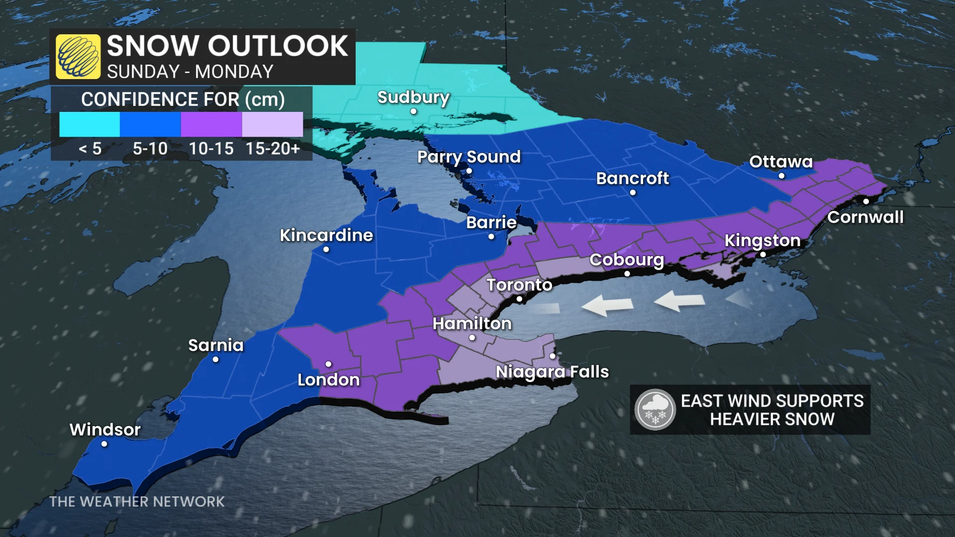
Confidence is building for significant Sunday snow in Ontario
We're keeping a close eye on a major winter storm that is set to develop south of the border, with models pointing to it clipping parts of southern Ontario with heavy snow on Sunday.
A destructive U.S. storm set to impact millions of Americans this weekend could potentially swipe southern Ontario on Sunday with significant snow.
Since the storm hasn't developed, yet, the exact storm track and snow totals are still highly uncertain. However, depending on the ultimate track, areas near and south of the Highway 401 corridor could see 10-20+cm.
DON’T MISS: Extreme cold targets Canada as the polar vortex buckles
And, to potentially make it more impactful, exceptionally cold air aloft with an easterly flow off Lake Ontario into the Greater Toronto Area (GTA) could enhance snowfall totals from lake-effect--possibly leading to localized storm totals of 30+cm.
Before the storm arrives, by the end of the week, extreme cold is expected to settle in, with temperatures dropping into the -20s and potentially lower when factoring in wind chill.
Here's what we know about the storm so far.
Sunday alert: Major U.S. storm to watch
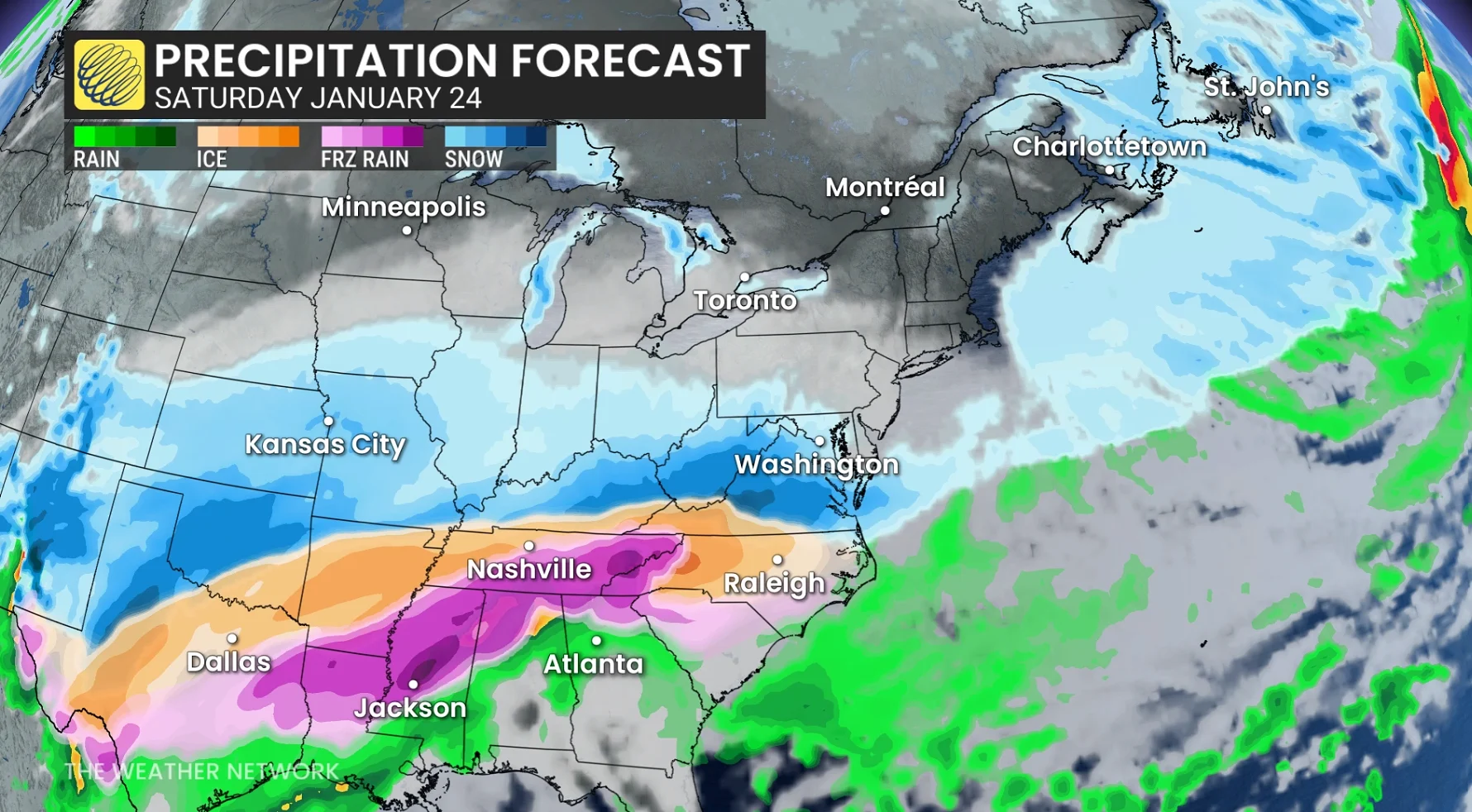
A major winter storm that is set to impact the U.S. Deep South will track up the East Coast through the weekend, bringing the potential for the northern extent of the low to scrape snow across southern Ontario on Sunday.
SEE ALSO: Snow paradox: Why 2 cm of snow can actually be worse than 25 cm
Frigid air from the polar vortex will plunge south across Canada and spread cold air as far south as the Gulf Coast of the U.S.
Moisture, energy, and milder air from the Pacific and Gulf of Mexico will meet this cold air and develop into a widespread, major winter storm across the southern U.S. It is forecast to spread a possible catastrophic amount of freezing rain and dumping of snow across the southern and eastern states.

The storm will ride northeast, towards the Mid-Atlantic and eventually off the Eastern Seaboard. Dependent on its track, it could bring the northern extent of the storm straight through southern Ontario, spreading a serious amount of snow for Sunday.
WATCH: High-impact storm shifting closer to southern Ontario
Confidence is building
A major storm will impact millions of Americans this weekend with widespread, frigid temperatures, significant snow, and dangerous freezing rain.
Frigid cold will also be locked in place across much of Canada this weekend.
RELATED: Big storm threatens widespread disruptions; U.S. airlines issue travel waivers
The storm will make its way northeast across the U.S. and towards the Atlantic Ocean into early next week, spreading its impacts thousands of kilometres long. There is high moisture that will be associated with this storm, so there will be a swath of very heavy snow, and a swath of significant ice.
Based on the current weather model guidance, southern Ontario will likely get swiped by the northern extent of this storm Sunday, spreading in widespread snow.
Storm track will be crucial
The storm hasn’t formed, and likely won’t until late Friday. So, until this storm forms, there is high amounts of uncertainty in its track and projected snow totals.
With uncertainty in the track of the storm, it leads to uncertainty in how much snow could impact southern Ontario Sunday.

The snowfall forecast will likely change through the course of the next few days as forecasters gain more weather data from weather models and observations once the system develops.
Frigid air to blanket Ontario this weekend, coldest temperatures in years for some
Frigid air will take over as the polar vortex settles across the region late week and into the weekend. Wind chills will plummet into the -30s, and even possibly -40s across northern Ontario.
DON'T MISS: The Great Lakes’ winter superpower is fading, polar vortex punches through
Ottawa may hit a low of -21°C, marking the city’s coldest day in 10 years if this forecast holds.
Next week begins with frigid conditions across the region, though a gradual temperature recovery is expected. However, reinforcing shots of Arctic air will likely disrupt this warming trend. A couple of Prairie Clippers are also anticipated to bring snowfall through the week.
Temperatures may approach seasonal levels by early February, but colder-than-normal weather could return later in the month.