Life-threatening Melissa expected to rapidly strengthen in coming days
Life-threatening flash flooding is possible in Jamaica and Haiti as slow-moving Melissa continues to strengthen and impact the region through the next week
Weather Highlights:
Hurricane Melissa is poised to rapidly intensify in the Caribbean
The system will continue to intensify through this weekend
Widespread life-threatening flash flooding expected in Jamaica and Haiti
Tourists in the region are urged to heed the advice of local officials
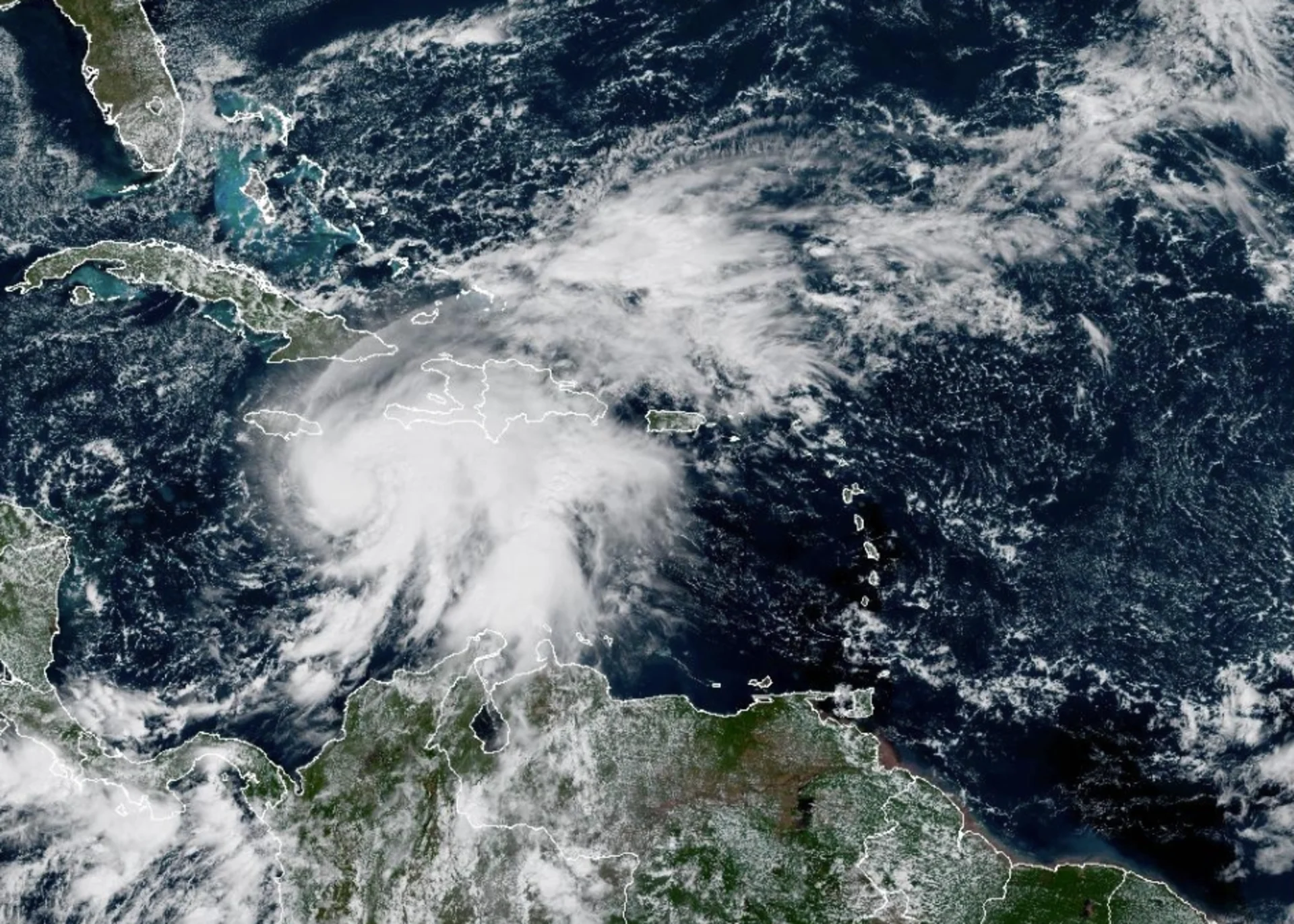
Melissa on the verge of rapid intensification
Millions of residents across the northern Caribbean are at risk for life-threatening flash flooding and mudslides into next week as a growing storm meanders through the region.

DON’T MISS: A stalled hurricane can produce disastrous flash flooding
Hurricane Melissa spent Friday and early Saturday getting better organized, and conditions will only grow more favourable for rapid intensification in the days ahead. Melissa could become a powerful, major hurricane by the end of the weekend.
Forecasters expect the storm to encounter lower wind shear and some of the western hemisphere’s hottest water temperatures in the days ahead.
Accordingly, the U.S. National Hurricane Center (NHC) anticipates that Melissa will grow into a high-end Category 4 storm near Jamaica by Monday. The only potential limitation may be the storm’s proximity to Jamaica, which could disrupt its structure.
"There is a distinct possibility that Melissa could become a Category 5 hurricane" late this weekend, the NHC said on Friday evening.
We've already had two Category 5 storms this year. If Melissa achieves this scale-topping feat, it would make history as only the second Atlantic hurricane season on record to see more than two Category 5 storms. (The leader, 2005, produced four: Emily; Katrina; Rita; and Wilma.)
A slow-moving hurricane could prove destructive
Weak steering currents around Melissa will force the storm to slowly drift west this weekend and into the beginning of next week, allowing high winds and drenching rains to wash over the mountainous terrain of Jamaica and southwestern Haiti for days at a time.

RELATED: What does a hurricane’s ‘cone of uncertainty’ mean?
Rainfall totals of 500+ mm are possible across portions of the region, which could lead to potentially devastating flash flooding and landslides. A persistent storm surge along Jamaica’s southern coast could also lead to dangerous coastal flooding, including around the capital of Kingston.
A trough swinging over the eastern U.S. will likely provide Melissa an escape route by Tuesday, forcing the storm to turn northeast and potentially make landfall in Jamaica before moving on toward eastern Cuba.
Based on current predictions, Melissa could become one of the strongest storms on record to strike Jamaica. The island nation’s current recordholder is 1988’s Hurricane Gilbert, which struck with 200 km/h winds and rainfall totals that topped 800 mm in some locations.
Potential Canadian impacts remain uncertain
It’s likely that the storm will exit the Caribbean and begin accelerating into the western Atlantic by the middle of next week.

Forecasters are watching the potential for some of Melissa’s moisture and energy to transfer to a developing centre of low pressure off the East Coast. This could fuel heavy rainfall across portions of Eastern Canada around Halloween.
Stay with The Weather Network for all the latest updates on the tropics. Header image courtesy of NOAA