
130+ km/h: Strongest winds since Fiona as 'weather bomb' slams Atlantic Canada
Powerful 'weather bomb' to hit Atlantic Canada with 120+ km/h wind gusts, heavy rain, and 8-metre wave heights
Weather Highlights:
A rapidly intensifying weather bomb is set to cross Newfoundland by late Tuesday evening
Potential for St. John's, N.L., to see a new November low pressure record
Eastern Newfoundland will see the strongest winds, with gusts of 90-100+ km/h, and more than 120 km/h near Sable Island and southeastern coasts, including St. John’s and the Avalon
Rainfall of 30-60 mm (locally higher) is expected across parts of Newfoundland and Cape Breton, N.S.
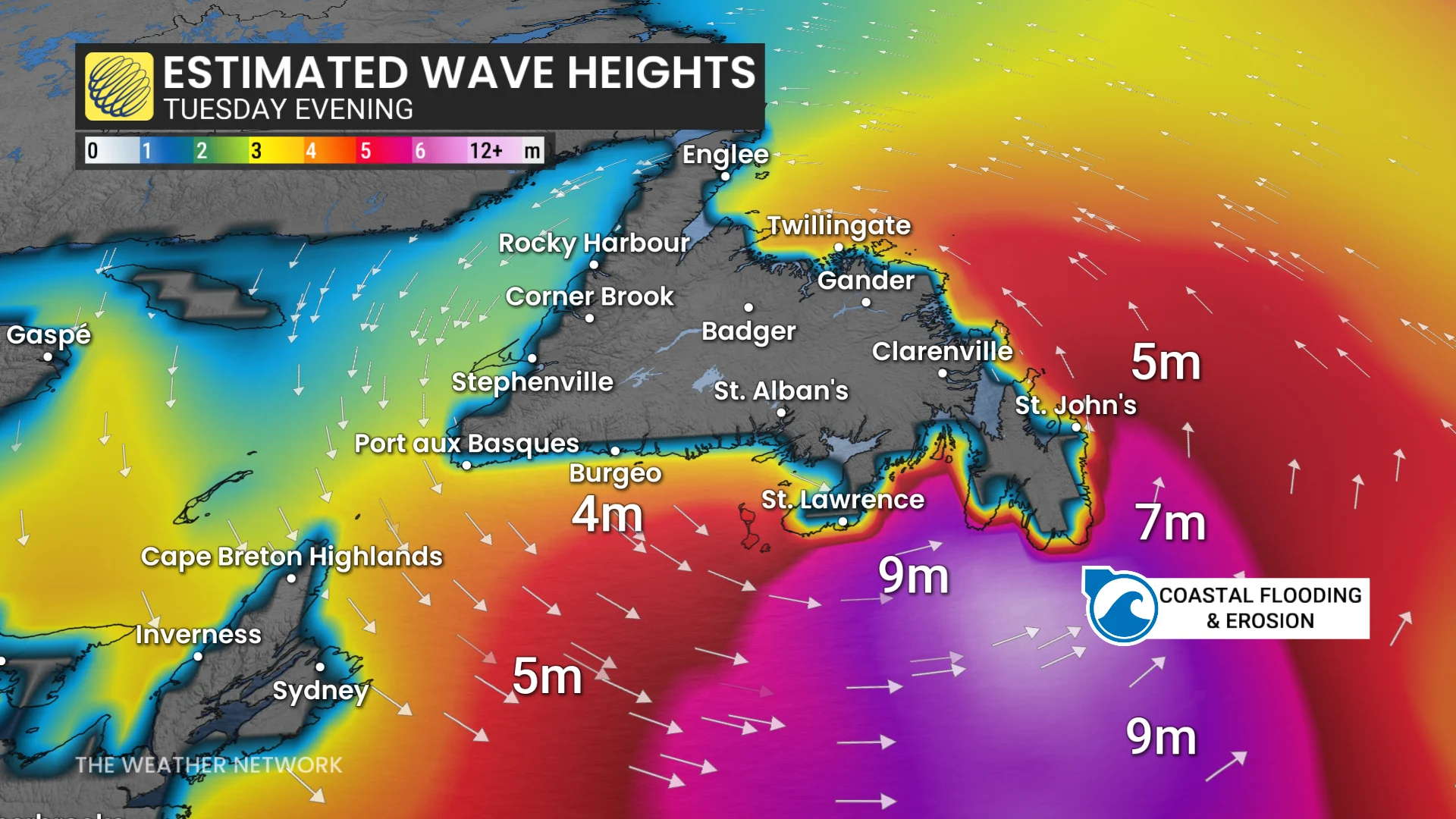
Heightened risk for power outages, downed trees, localized flooding, coastal erosion, and large waves reaching 6-8+ metres.

Record-setting storm threatens outages and travel impacts through Wednesday:
Storm impacts begin across Newfoundland Tuesday morning, but will peak as the low reaches minimum pressure Tuesday evening, and crosses the province at a record-breaking deep pressure for November around 950 mb.
The storm will undergo bombogenesis-–the rapid intensification of a low pressure system in a short period of time. The warmer waters of the Atlantic Ocean will also lend the system a boost as it tracks up the coast.
DON'T MISS: 'Weather bombs': Explosive storms that create ferocious conditions
Heavy rain, large waves, and damaging winds are expected. A peak wind gust of 131 km/h was already reported at Sable Island, N.S. Tuesday morning, marking the strongest gust at the station since September 24, 2022 when Fiona hit as a post-tropical cyclone.

Be prepared for power outages and potential travel impacts. Marine Atlantic has cancelled ferry crossings through Wednesday morning.
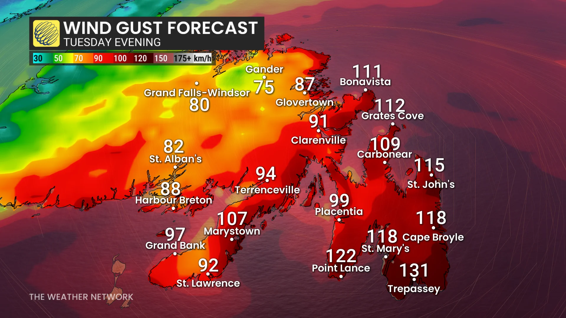
Powerful wind gusts between 110-130+ km/h
Rain spread over Newfoundland late Tuesday morning, with heavy, wet snow expected in higher elevations of the island. Strong winds will be the most significant impact, however.
Gusts will increase to over 80 km/h by late morning, peaking at 110-120+ km/h Tuesday evening into the overnight period.
Trepassey could face wind gusts exceeding 130 km/h, potentially causing damage.
High tide at 6:58 p.m. local time will coincide with the strongest winds, as well, heightening the risk of coastal flooding in areas such as the Burin Peninsula and southern Avalon.
Coastal flood warning in effect
"A combination of storm surge, large waves, and pounding surf, coinciding with high tide, will push water beyond its usual reach, exceeding the highest astronomical tide," says Environment and Climate Change Canada (ECCC) in a coastal flood warning.
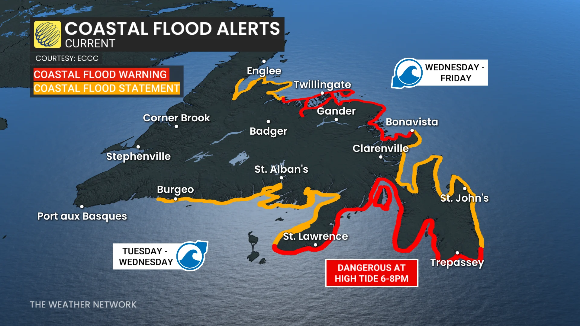
"Stay away from the shore to prevent being swept off rocks, injured by driftwood or pulled out to sea."
SEE ALSO: The biggest, brightest Supermoon of 2025 rises Tuesday night!
Maximum wave heights could reach between 6-8+ metres at high tide.
St. John’s could experience gusts near 100 km/h or more for over 12 hours, with damaging westerly and northwesterly winds continuing through Wednesday. It has been quite a while since Newfoundland was impacted by a storm of this caliber, with the last 110+ km/h gust in St. John's reported on January 5, 2025.
P.E.I. and western Cape Breton may also see northwesterly gusts of 90-100 km/h Tuesday night.
DON'T MISS: Canada’s November features extended fall, but winter lurks on the sidelines
The heaviest rainfall axis will be north of the track of the low, so Cape Breton, N.S., and central and western Newfoundland are forecast to see a widespread swath of 30-60 mm, with locally higher amounts possible.
Rainfall forecast:
Sydney: 50-75 mm
Port aux Basques: 40-60 mm
Burgeo: 40-60 mm
Gander: 40-50 mm
St. John's: 30-40 mm
Halifax: 20-40 mm

Impacts throughout the storm may include power outages, downed trees, minor structural damage, localized flooding in Cape Breton and Newfoundland, as well as coastal erosion due to monster waves reaching 6-8+ metres.
By Wednesday morning, the powerful low lifts northeast of the province, with winds gradually easing and precipitation becoming more scattered through the afternoon.
Stay updated as the storm progresses. Weather conditions will likely present risks for travel and infrastructure in the region.
WATCH: How a 'weather bomb' forms and what it means
Stay tuned to The Weather Network for the latest forecast updates for Atlantic Canada.