Humberto rapidly intensifies to a major hurricane, Imelda next on deck
Humberto is now a major hurricane, while the next system is on the verge of growing into Imelda
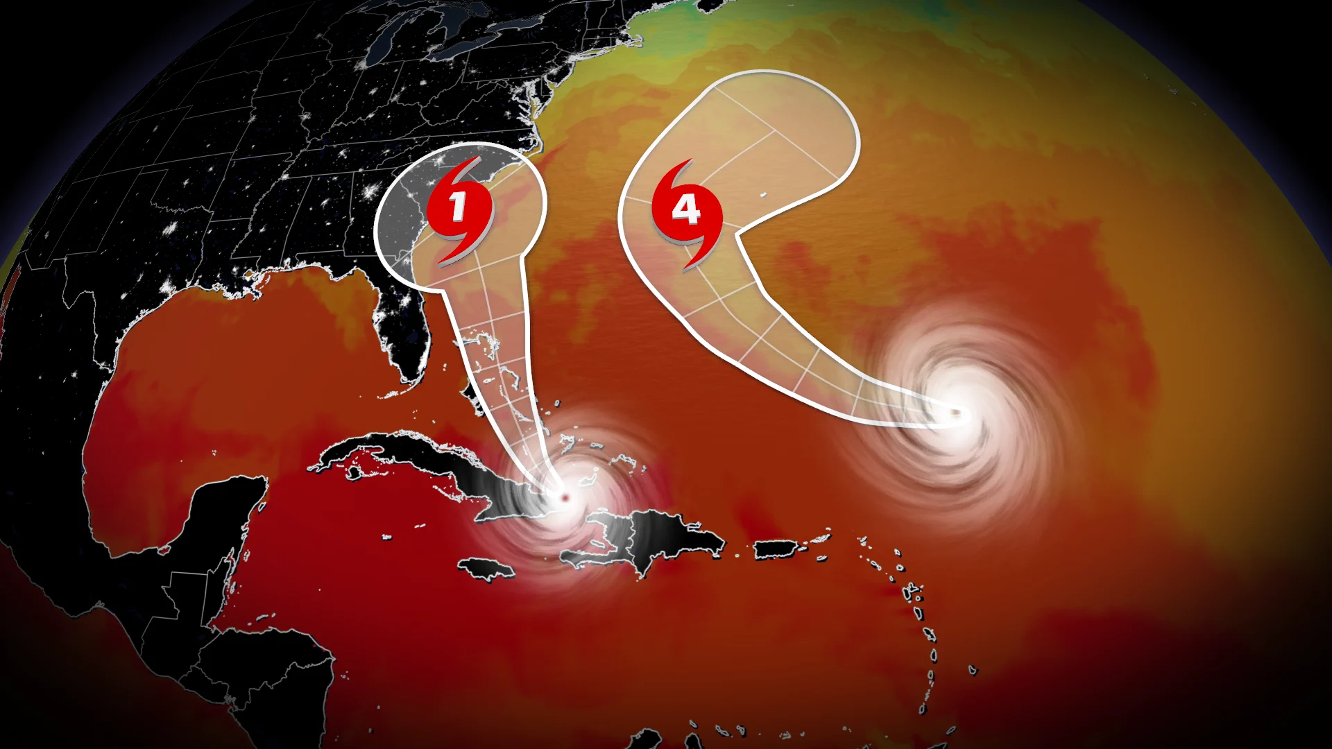
Hurricane Humberto rapidly intensified into a major hurricane on Friday as the latest burst of tropical activity continues in the southwest corner of the basin.
Forecasters are watching another system not far behind for potential wind and flooding impacts in the southeastern United States—just one year after Helene devastated parts of the region.
DON’T MISS: What does a hurricane's ‘cone of uncertainty’ mean?
Humberto rapidly intensifies into a major hurricane
A favourable environment allowed Humberto to undergo rapid intensification on Friday as it passed far north of the Leeward Islands.

The U.S. National Hurricane Center (NHC) found that Humberto reached major Category 3 strength on Friday evening with maximum winds of 185 km/h. The agency expects the system could grow into a high-end Category 4 storm by this weekend as it moves northwest through the open Atlantic Ocean.
Humberto is this season’s third hurricane behind Erin and Gabrielle. This is the first time in 90 years we’ve seen a season’s first three hurricanes intensify to Category 3 status or stronger, according to hurricane expert Philip Klotzbach.

This hurricane isn’t expected to directly affect land within the next five days, though Bermuda should monitor its progress early next week. A moderate to high risk for rip currents will exist across the U.S. East Coast and Atlantic Canada for at least the next couple of days.
Future Imelda brewing near the Bahamas
Another system nearby may cause some serious issues across the southeastern U.S. early next week.
The NHC began issuing advisories on Potential Tropical Cyclone Nine on Friday evening. This special designation allows forecasters to issue watches and warnings on a tropical disturbance that’s expected to develop and hit land within the next 24 to 48 hours.
RELATED: The high-stakes factors that decide where a hurricane tracks
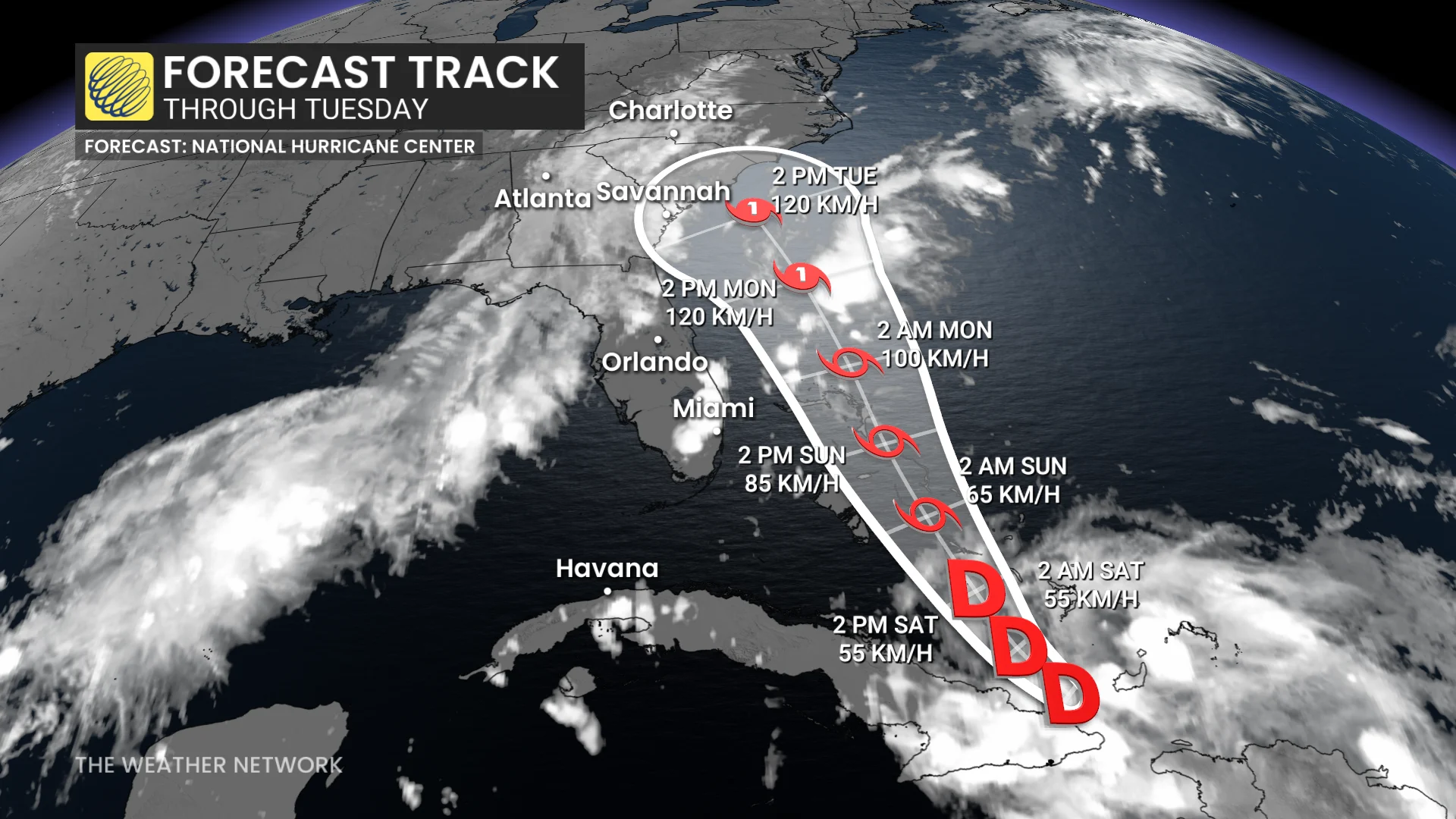
Meteorologists expect this system to organize into Tropical Storm Imelda by Saturday as it moves through the Bahamas.
The forecast grows trickier from there. The latest trends indicate that the system will strengthen and approach the southeastern United States with gusty winds and flooding rains. Some areas could easily see 200-400+ mm of rainfall through the middle of next week.
Uncertainty is greater than usual, though, and there’s a chance that Hurricane Humberto interferes with this developing system and pulls it farther out to sea.
Anyone with interests in the Bahamas, Georgia, the Carolinas, or Virginia should closely monitor the progress of this system heading into early next week.

A tropical system in this part of the world is unwelcome news as western North Carolina continues recovering from the devastating flooding inflicted by Hurricane Helene last September.
North Carolina Governor Josh Stein’s office reported on Sept. 25 that 95 per cent of public roads damaged by Helene’s flooding have been repaired, and 57 per cent of public bridges damaged during the storm have been repaired or replaced. Crews had removed more than 6.1 million cubic metres of debris from waterways as of Sept. 16.
Stay with The Weather Network for all the latest tropical updates.
Header image courtesy of NOAA.