East Coast beachgoers urged to stay away as Hurricane Erin brings dangerous surf
Hurricane Erin, despite remaining far offshore, is creating hazardous surf and rip current conditions along much of the U.S. East Coast, and will soon impact parts of Atlantic Canada
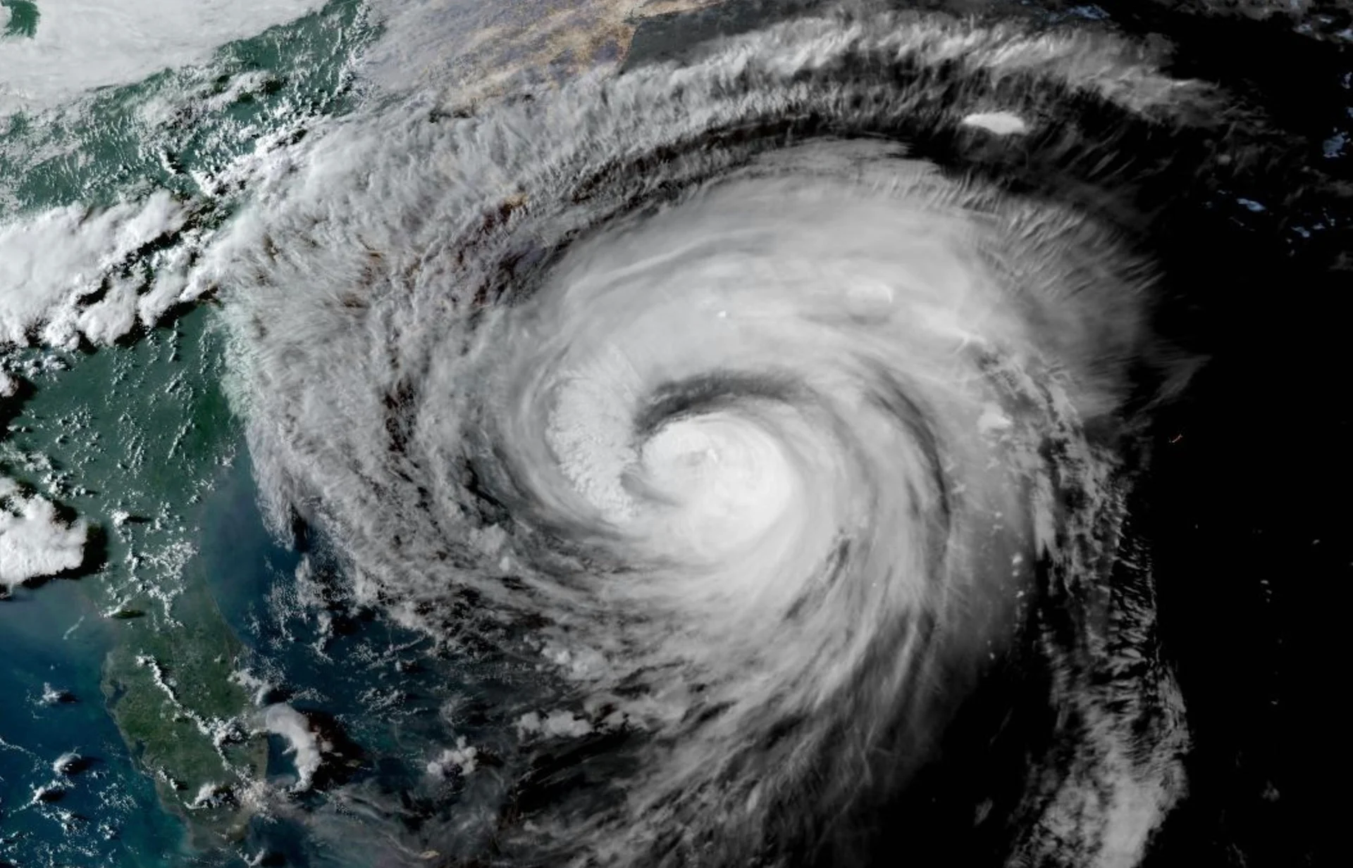
Hurricane Erin is intensifying wave activity, generating dangerous coastal conditions for much of the U.S. East Coast. Erin's unusually large size enhances its ability to create hazardous conditions, despite remaining well offshore. A high risk of rip currents is in effect along coastal areas from Florida to southern New York.
DON’T MISS: An inside look at Hurricane Erin’s astounding rise to Category 5
The U.S. National Weather Service is warning residents to heed guidance from lifeguards, local authorities, and posted beach warning flags.
Evacuations and storm surge warnings
North Carolina is under a state of emergency, with evacuations ordered for parts of the Outer Banks. The region is expected to face significant storm surge and destructive waves reaching 20 feet or more. The outer bands of Hurricane Erin are expected to deliver 25 mm of rainfall to the Outer Banks of North Carolina through Thursday.
A storm surge warning is in effect from Cape Lookout to Duck, N.C. A tropical storm warning has been issued for areas from Beaufort Inlet, N.C., to Chincoteague, Va., including the Pamlico and Albemarle Sounds.
Meanwhile, a tropical storm watch is in effect for Bermuda.
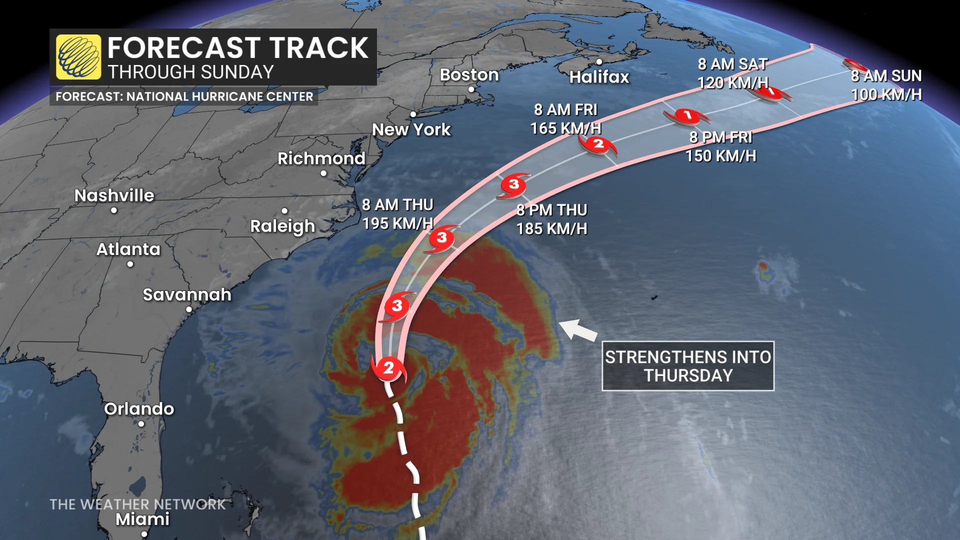
Erin maintained its Category 2 strength on Wednesday, with maximum sustained winds of 175 km/h.
According to the forecast, Erin’s centre will move over the western Atlantic between the U.S. East Coast and Bermuda Wednesday through early Friday. It is then expected to pass south of Atlantic Canada on Friday and Saturday.
SEE ALSO: Powerful, dangerous Hurricane Erin could generate 100-foot waves
Erin is likely to undergo further strengthening over the next 24 hours and could regain major hurricane status by Wednesday night. Weakening is expected to begin on Friday, but the system is forecast to remain a hurricane into the weekend.
WATCH: Hurricane Erin's winds cause concern for N.S. firefighters
Erin's wave field could span 5,000 km
Erin is a large system, with hurricane-force winds reaching up to 165 km from its centre. Tropical storm-force winds extend even farther, up to 425 km outward. The extensive wave field of the storm is projected to span over 5,000 km, reaching from Bermuda and east of Atlantic Canada to Europe in the coming week.
Heavy wave activity expected in Eastern Canadian waters
According to the Canadian Hurricane Centre (CHC), given the large size of Erin, it is likely to bring high seas and winds to Eastern Canadian offshore waters.
Hurricane Erin is tracking northward between the Carolinas and Bermuda with recently increasing core winds, as well as an expanding area of hurricane-force winds. The centre will track well east of North Carolina but that area is still expecting tropical storm conditions and dangerous waves.

RELATED: Surfers await Hurricane Erin’s potentially dangerous waves in Nova Scotia
Hurricane Erin will bring high seas and winds to Eastern Canadian offshore waters. Dangerous surf is also expected along the south-facing Atlantic coastlines of Nova Scotia and Newfoundland Friday and Saturday.
"At this stage the main impact to the public will be from the large ocean swell with associated surf and rip currents--of particular risk along the Atlantic coast of Nova Scotia Friday," the Canadian Hurricane Centre said in its latest update.
Also on Friday, as the very broad circulation of Erin tracks well south of Nova Scotia, there will likely be some high-altitude cloud cover and gusty northerly winds in the afternoon and evening, especially near the Atlantic coast. No rainfall is expected.
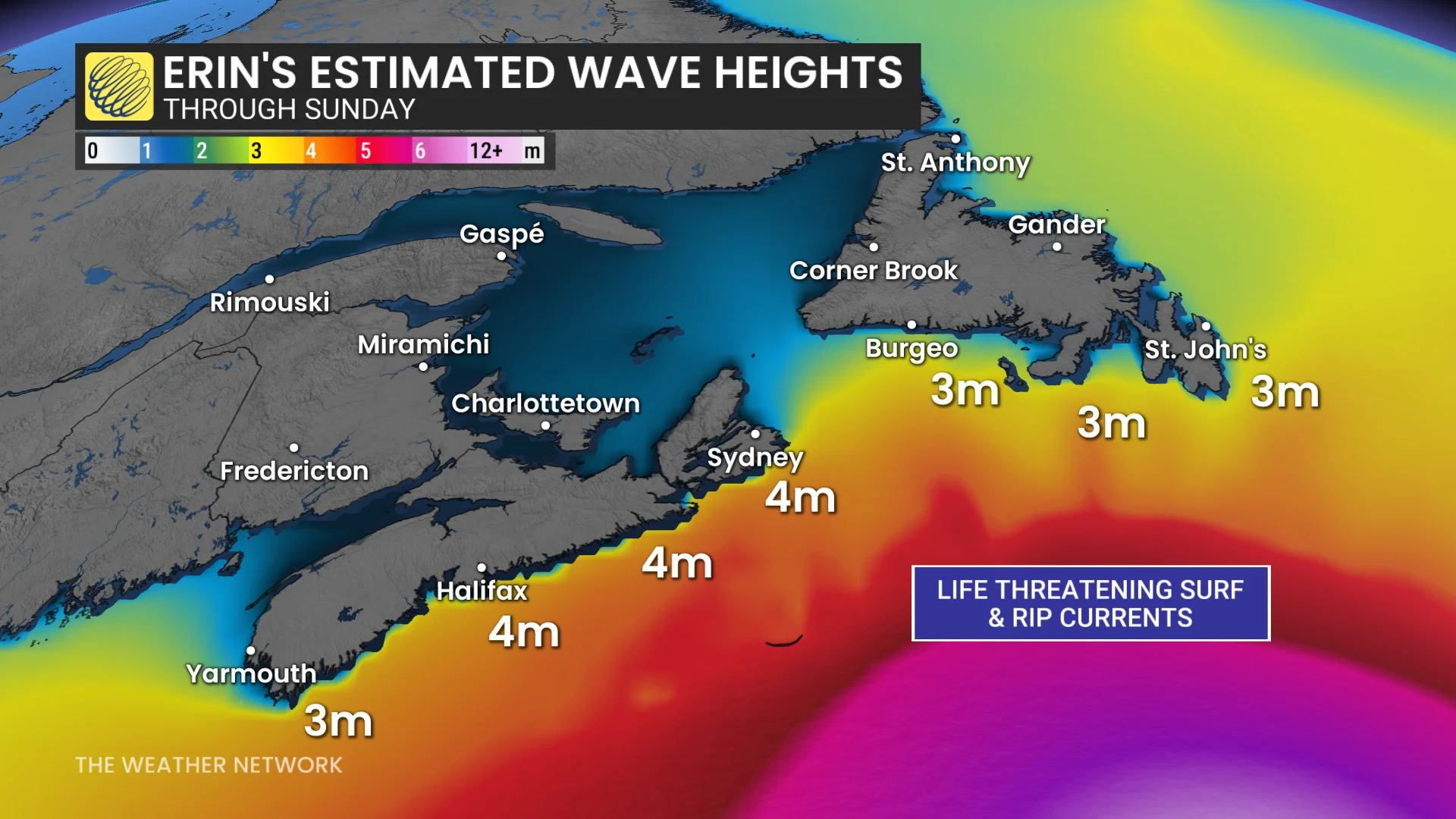
Key offshore areas to monitor closely include all of the southern Maritimes marine forecast district, as well as the Grand Banks of Newfoundland. Storm- to near hurricane-force winds are possible over southern portions of these forecast zones.
STAY SAFE: Rip currents are a natural hazard along coasts – here’s how to spot them
Always heed the advice and orders of local officials and stay out of the water if there’s a threat for rip currents. Don’t panic if you’re ever caught in a rip current.
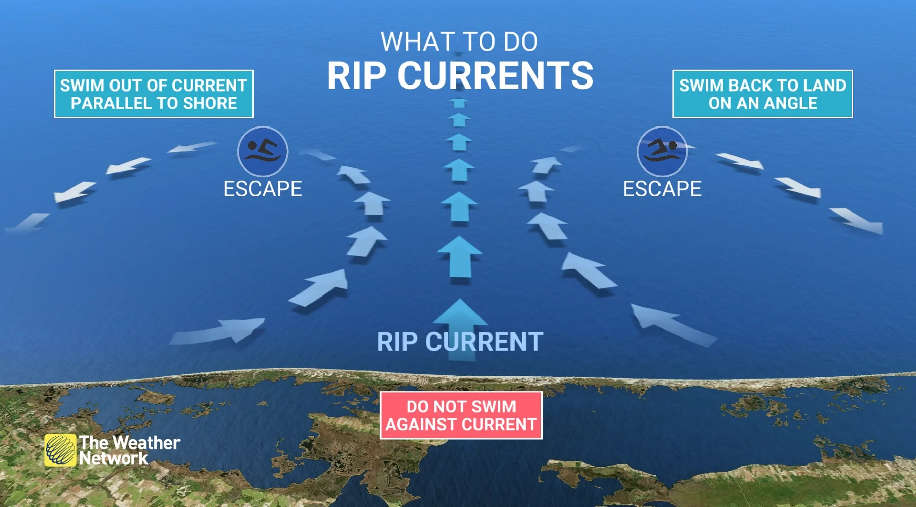
If you can’t swim, calmly signal for help and tread water until assistance arrives. Swimmers should swim parallel to the beach until you’re out of the rip current, then swim back to shore.