U.S., Canada East Coast braces for Erin's dangerous swells, rip currents
Tropical storm alerts have been extended farther north along the U.S. Eastern Seaboard as Hurricane Erin begins its northward trek, threatening to bring hazardous surf and rip currents to parts of North America's East Coast including some Atlantic Canada areas
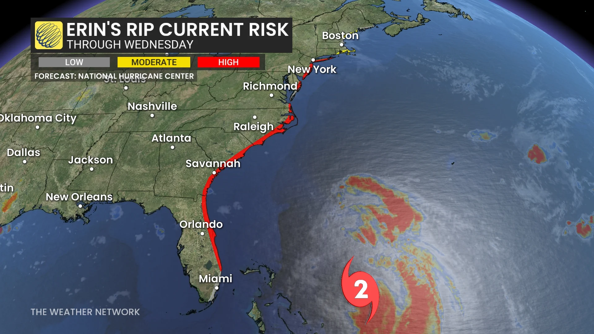
Hurricane Erin is forecast to generate dangerous surf and rip currents over the next several days, affecting beaches in the Bahamas, much of the U.S. East Coast, Bermuda, and Atlantic Canada.
DON’T MISS: An inside look at Hurricane Erin’s astounding rise to Category 5
The U.S. National Weather Service is warning beachgoers in these regions to heed guidance from lifeguards, local authorities, and posted beach warning flags.
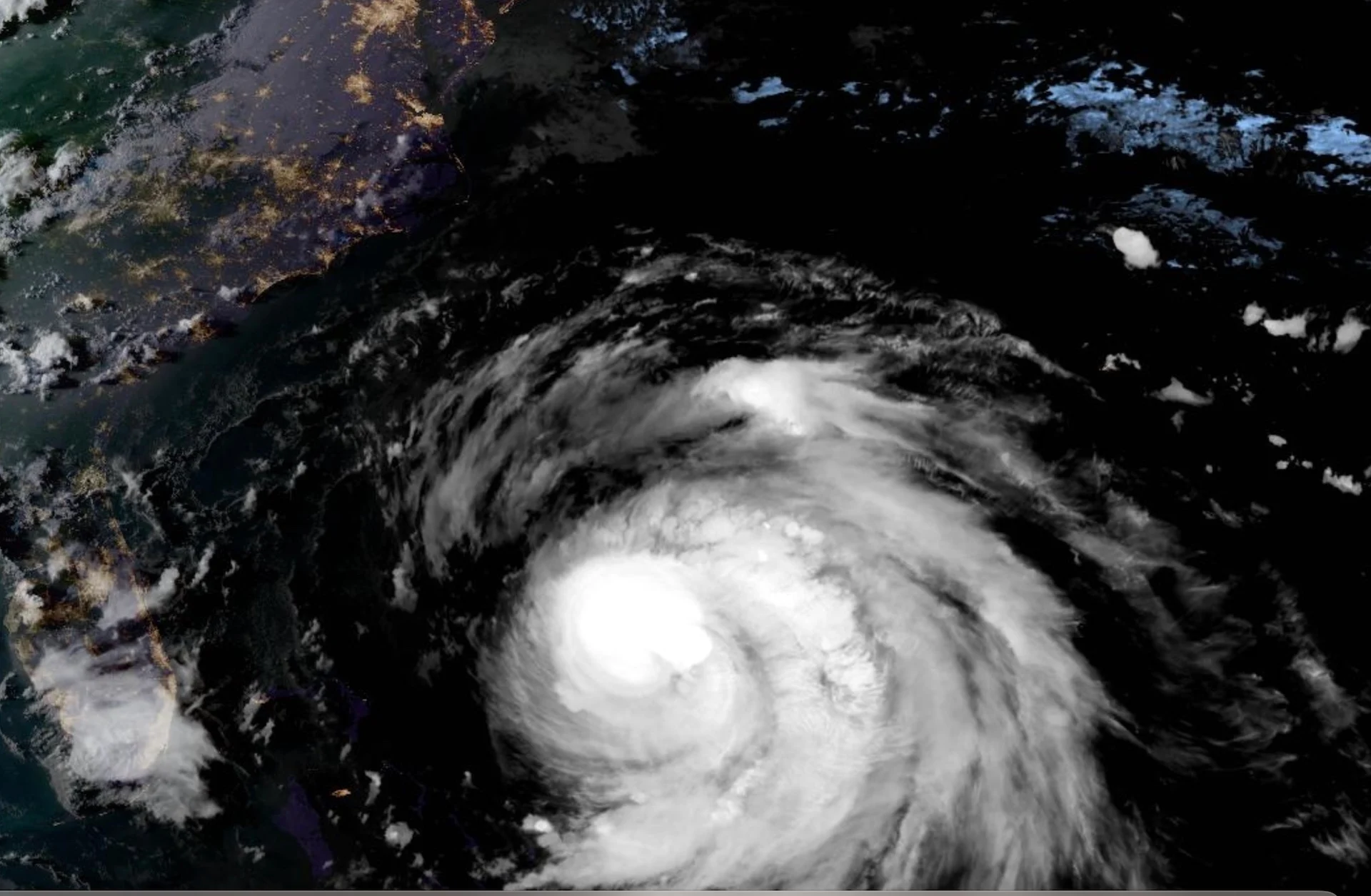
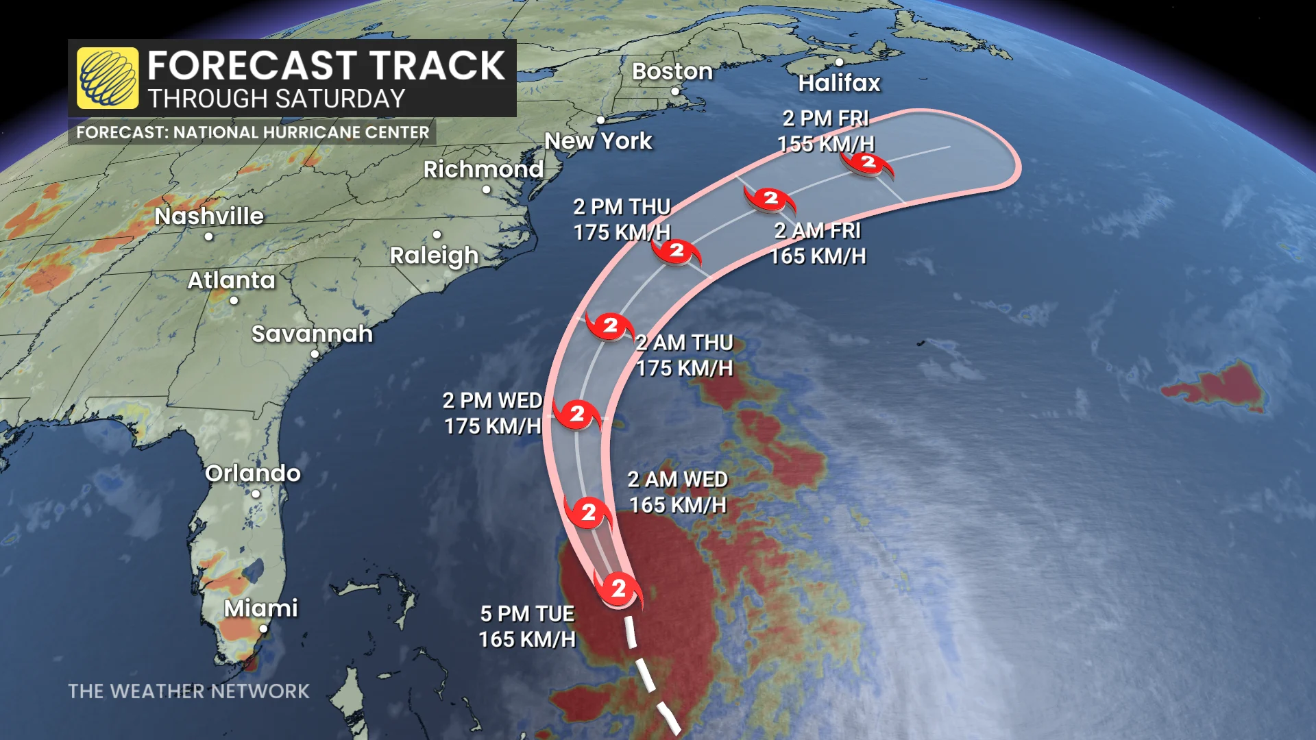
Despite dropping to a Category 2 storm on Tuesday, Erin is expected become even larger while moving over the Western Atlantic throughout the week.
A tropical storm warning is in effect from Beaufort Inlet to Duck, N.C., including Pamlico and Albemarle sounds. A storm surge warning is currently in effect for Cape Lookout to Duck, N.C.
Meanwhile, the tropical storm watch has been extended northward along the U.S. Atlantic coast, from north of Cape Charles Light, Va., to Chincoteague, Va. It is also in effect for Bermuda.
SEE ALSO: Powerful, dangerous Hurricane Erin could generate 100-foot waves
According to the forecast track, the centre of Erin will pass east of the Bahamas on Tuesday night before moving over the Western Atlantic between the U.S. East Coast and Bermuda on Wednesday and Thursday.
Fluctuations in strength are possible over the next few days.
SEE ALSO: La Niña watch issued for this winter as key factors signal change
Rainfall will be diminishing across the Turk and Caicos, and the Bahamas Tuesday night. Heavy rainfall is possible on the Outer Banks of North Carolina Wednesday night into Thursday, with the potential for 25-50 mm.
Erin is a large hurricane. Hurricane-force winds extend outward up 130 km from the centre and tropical-storm-force winds extend outward up to 370 km.
Watching for large swells over Atlantic Canada
According to the Canadian Hurricane Centre (CHC), given the large size of Erin, it is likely to bring heavy wave activity to Eastern Canadian waters and also to the south-facing Atlantic coastlines of Nova Scotia and Newfoundland Friday and Saturday.
"At this stage we don't expect the storm to impact land other than the ocean swell, which will likely create hazardous surf conditions including rip currents - of particular risk along the Atlantic Coast of Nova Scotia Friday," said the CHC in the Tuesday statement.
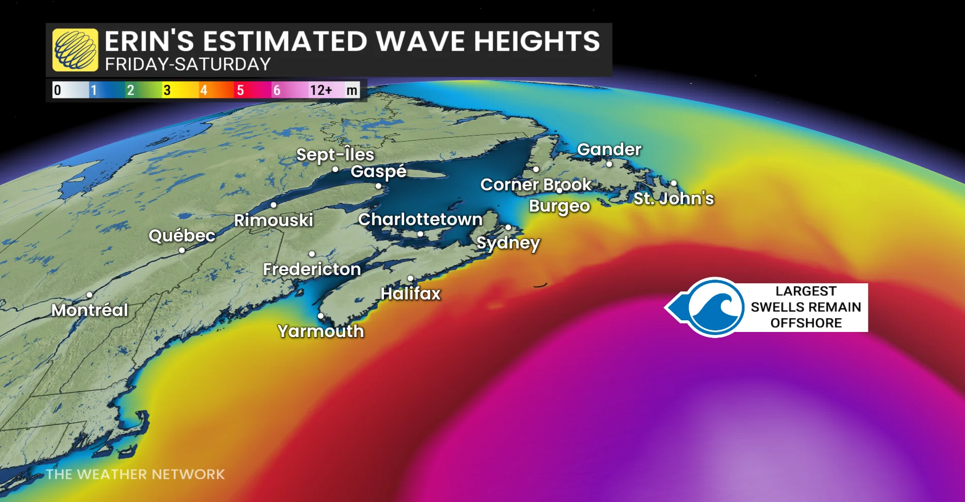
Key offshore areas to monitor closely include George's Bank, the Scotian Slope, Laurentian Fan and the Southern Grand Banks. Storm-force winds are also possible over southern portions of these forecast zones.
Swells from Erin are forecast to impact the Bahamas, Bermuda, and the U.S. East Coast over the next several days. These elevated ocean conditions are likely to create life-threatening surf and rip currents.
STAY SAFE: Rip currents are a natural hazard along coasts – here’s how to spot them
Always heed the advice and orders of local officials and stay out of the water if there’s a threat for rip currents. Don’t panic if you’re ever caught in a rip current.
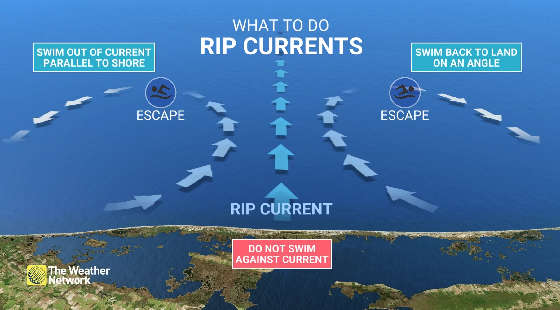
If you can’t swim, calmly signal for help and tread water until assistance arrives. Swimmers should swim parallel to the beach until you’re out of the rip current, then swim back to shore.
Thumbnail courtesy of NOAA.