
Humberto's role: A wild card steering where the next hurricane goes
While Humberto dropped down a status to a Category 4 storm, it remains an 'extremely dangerous' hurricane that could have some influence over where Tropical Depression Nine ultimately ends up this week--with at least some impacts expected for the U.S. Southeast
After Hurricane Humberto briefly became a Category 5 storm Saturday, earning itself a spot in the history books for its achievement, forecasters are looking at how the powerful storm could steer the next Atlantic disturbance, Tropical Depression Nine, into or away from the southeastern U.S. coastline this week.
Regardless of where Tropical Depression Nine ultimately ends up, the future Imelda will still pose a threat to some degree across the southeastern United States this week. The recurvature of the depression will be influenced by the outflow and track of Hurricane Humberto.
DON’T MISS: What does a hurricane's ‘cone of uncertainty’ mean?
Interests in Bermuda should monitor the progress of Humberto, as watches could be required later on Sunday, while those in the Bahamas and the southeastern U.S. need to keep a close eye on Tropical Depression Nine.
Hurricane Humberto downgraded, but still extremely dangerous Category 4

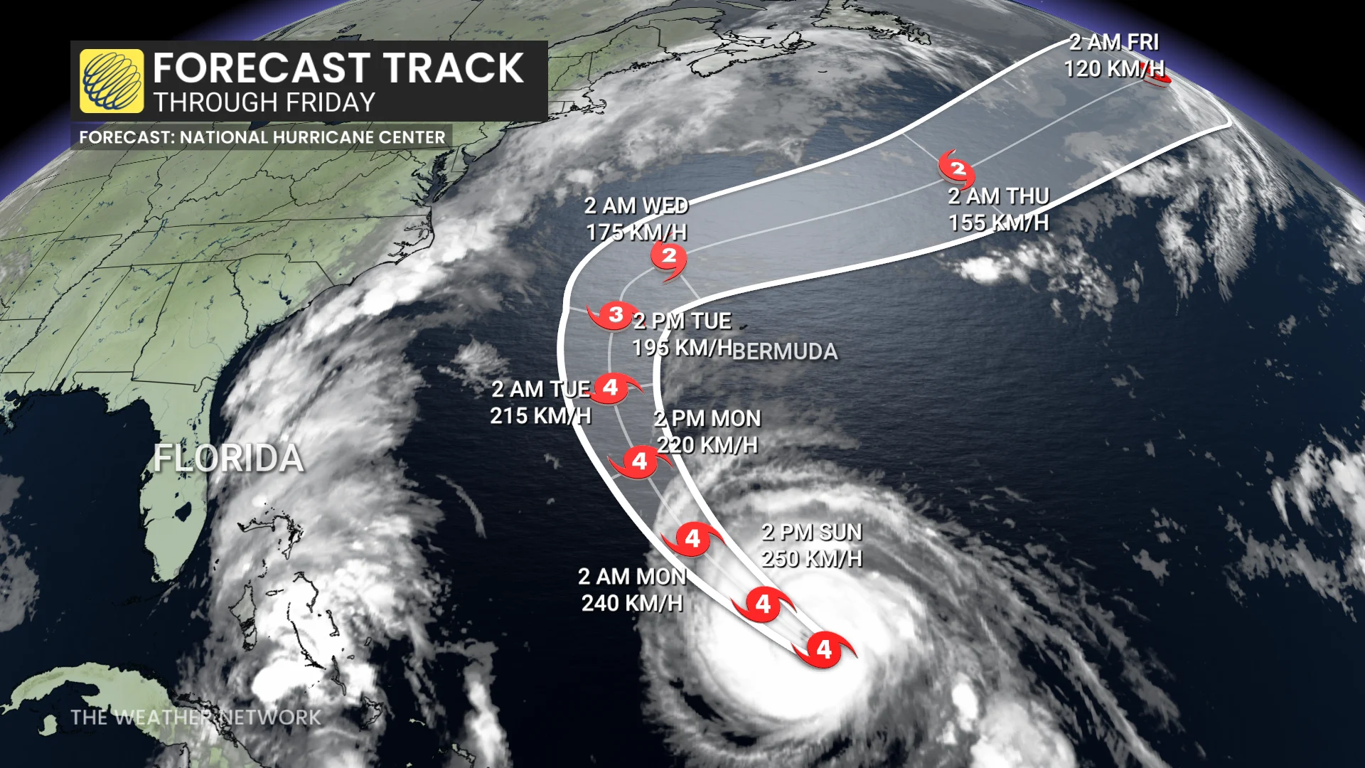
Forecasters found Hurricane Humberto’s maximum winds reached 260 km/h on Saturday evening, topping the scale and placing the storm among a rare few in Atlantic storm history.
Humberto is now the 44th hurricane in the Atlantic to hit Category 5 intensity. This is the 12th storm to achieve that feat in the past 10 years, and the sixth to do so since 2022.
However, the storm has since lost some strength and has dropped down to a Category 4 storm once more. As of early Sunday afternoon, maximum, sustained winds remain near 240 km/h. Fluctuations in intensity are possible during the next day or so.

Humberto has a clear and symmetric eye with a diameter of 15 km. Environment supports peak intensity for the next 12 hours, but a gradual weakening trend is anticipated through early this week as wind shear increases.
Humberto should remain a powerful, major hurricane for the next couple of days as it rounds a large ridge of high pressure parked over the central part of the Atlantic Ocean. Humberto is forecast to make a gradual turn toward the northwest, and then northward over the next couple of days. By the middle of the week, Humberto is forecast to begin accelerating toward the east-northeast.
Dangerous swells generated by Humberto will continue to affect portions of the northern Leeward Islands, the Virgin Islands, Puerto Rico and Bermuda through much of this week, and will begin to affect the U.S. East Coast beginning on Monday.
Rip currents are a deadly hazard to even the strongest swimmers.
Tropical storm watches issued in Florida ahead of secondary system
Farther west, Tropical Depression Nine continued to gradually organize as it pushed north through the Bahamas on Saturday.
This system, expected to become Tropical Storm Imelda by Sunday, will come close to the southeastern U.S. by Monday and Tuesday. While the portions of the Bahamas are under tropical storm warnings, tropical storm watches are in effect for parts of the Florida coast ahead of the storm’s arrival.
RELATED: The high-stakes factors that decide where a hurricane tracks

Tropical Depression Nine is forecast to bring heavy rains over portions of eastern Cuba and the Bahamas Sunday, with winds increasing over the latter sometime on Sunday.
As of Sunday afternoon, maximum and sustained winds are near 55 km/h with higher gusts. Strengthening is expected during the next few days, and the system is forecast to become a tropical storm on Sunday and a hurricane by late Monday or Tuesday.
A complex atmospheric setup will cause steering currents to collapse around the system as it approaches the U.S. early this week, forcing the storm to slow to a crawl.
The U.S. National Hurricane Center (NHC) is leaning to keeping it offshore--from Georgia to North Carolina--following Humberto's path out to sea.
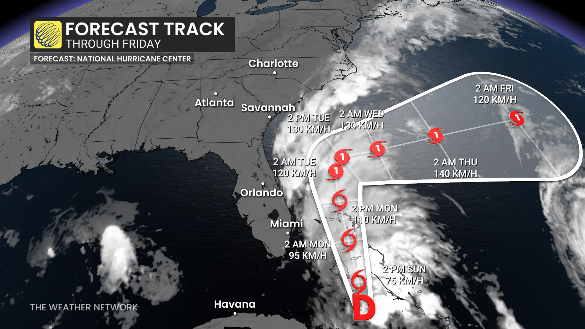
The current scenario, as outlined in the latest NHC forecast and alluded to above, is for the centre of the system to move across the central and northwestern Bahamas Sunday, and then turn east-northeastward, moving away from the southeastern U.S. by the middle part of this week.
An interaction with a frontal system by midweek means the system will likely begin the process of extratropical transition.
It’s still possible that the system will come much closer to land, which would greatly increase the flooding impacts of very heavy rainfall across Georgia, the Carolinas and Virginia.
Tropical Depression Nine is expected to produce additional rainfall of 50 mm to 150 mm across eastern Cuba, and 150 mm to 300 mm across the northwest Bahamas through Tuesday. This rainfall will likely produce flash and urban flooding. Mudslides are also possible in areas of higher terrain across eastern Cuba.

Storm total rainfall amounts of 50 mm to 100 mmm, with locally up to 175 mm, are expected into Wednesday morning across portions of the coastal Carolinas. This rainfall could result in flash, urban, and isolated, minor river flooding. Changes in the forecast track could result in further adjustments to those rainfall totals.
A storm surge will raise water levels by as much as 0.30 metres to 0.91 metres above ground level along the immediate coast in areas of onshore winds in the northwestern Bahamas. Near the coast, the surge will be accompanied by large waves.
Anyone with interests in the Bahamas and along the southeast coast of the U.S., from Florida to North Carolina, should monitor the progress of this system. Additional watches or warnings could be required later on Sunday.
Stay with The Weather Network for all the latest updates on the tropics.