
Humberto maintains major hurricane strength, Imelda gains attention
The tropics remain active heading into the final days of September
Two named storms in the southwestern Atlantic bear watching over the next couple of days as a complex setup forces the storms to thread the needle around land.
Humberto remains a powerful major hurricane on Monday after peaking at Category 5 intensity on Saturday.
Imelda formed over the Bahamas as it carves a precarious path just off the southeastern U.S. coast. Forecasters expect Humberto to essentially slingshot Imelda on a hard-east path—possibly directly toward Bermuda.
DON'T MISS: The incredible history and tools of the Hurricane Hunters
Humberto still a powerful Category 4 hurricane
Hurricane Humberto weakened slightly on Sunday after spending the overnight hours at scale-topping Category 5 intensity. The intense storm continued to pack maximum sustained winds of 230 km/h as of Monday morning.
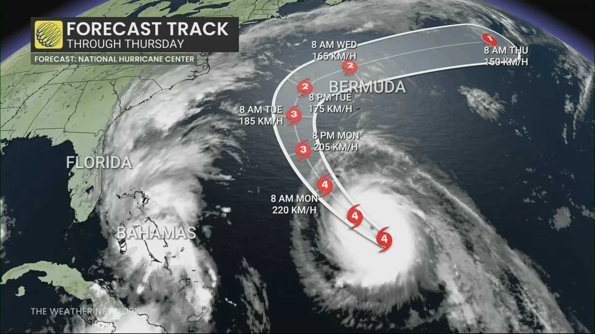
Forecasters with the U.S. National Hurricane Center (NHC) expect the storm to recurve out to sea through the upcoming week, steered along by a strong ridge of high pressure parked over the central Atlantic.
The storm may pass close enough to bring tropical storm conditions to Bermuda by Tuesday, where a tropical storm watch is now in effect.
Dangerous rip currents are expected across Bermuda, the U.S. East Coast, and Atlantic Canada this week as Humberto continues to churn through the region.
Imelda finally forms, heading north for now
Tropical Storm Imelda made its long-anticipated appearance over the Bahamas on Sunday as the system gradually got its act together.
Forecasters expect Imelda to strengthen into a hurricane by Tuesday as the storm heads north out of the Bahamas.
RELATED: Hurricane terms everyone should know as the season heats up

The system’s slow development, and slow forward movement, will likely prove beneficial for the southeastern U.S. coast. Hurricane Humberto will cause a weakness in that ridge of high pressure over the Atlantic, providing Imelda an off-ramp of sorts to make a hard turn toward the east.
This sharp deviation will significantly reduce the amount of wind and rain expected along the U.S. coast.
However, this turn could also put Bermuda directly in the storm’s path by the latter half of this week. As Imelda passes near Bermuda, 50 to 100 mm of rainfall is expected from Wednesday into Thursday, the NHC says.
Interests on the island should pay close attention to forecast updates in the days ahead.