
Historic 'weather bomb' blasts Newfoundland with 170+km/h winds, massive waves
A ferocious, historic fall storm has battered Newfoundland with 170+ km/h wind gusts, heavy rainfall and snowfall, along with monster waves exceeding nine metres, with conditions expected to remain hazardous into Wednesday
Weather Highlights:
A volatile weather bomb has brought hurricane-force wind gusts and massive waves to Newfoundland
Thousands without power; several people in community of Trepassey evacuated due to waves and winds
New November pressure record set in St. John's, with barometric pressure falling to below 960 hPa.
Locally heavy snowfall reported in several communities including Massey Drive, Grand Falls-Windsor and Gander
Strongest wind gust has topped 170+ km/h, with wave heights exceeding nine metres
Heightened, additional risk for power outages, downed trees, localized flooding, coastal erosion.
Storm impacts are expected to continue into Wednesday before subsiding

Record-setting, damaging storm brings outages and travel impacts:
The volatile storm had undergone bombogenesis-–the rapid intensification of a low-pressure system in a short period of time--earning the weather bomb moniker.
DON'T MISS: 'Weather bombs': Explosive storms that create ferocious conditions

As a result of the intensification, an all-time November sea-level pressure was set for St. John’s, with the barometric pressure falling to below 960 hPa––breaking the previous record of 971.4 hPa for the month.
Heavy rain, large waves, and damaging winds have been reported.
The storm has knocked out power for more than 9,000 residents, and prompted some families in the southern Avalon community of Trepassey to evacuate their homes as a result of the crashing waves and winds.

Peak wind gusts as of 8 p.m. NT
Cape St. Mary's: 172 km/h
Cape Race: 162 km/h
Cape Pine Lightstation: 156 km/h
Sagona Island: 155 km/h
Trepassey: 152 km/h (personal weather station)
Burgeo: 112 km/h
St. John’s: 107 km/h
The 172 km/h gust reported at Cape St. Mary's is the strongest in the region since Hurricane Larry whipped through with 182 km/h wind gusts in September 2021.
Rainfall observations (Through 8 p.m. Tuesday NT)
Sydney: 50 mm
St. Lawrence: 43 mm
Burgeo: 35 mm
St. Johns: 30 mm
Port aux Basques: 22 mm
Gander: 21 mm
Halifax: 11 mm

The storm surge peaked at 80 cm in St. Lawrence in the Burin Peninsula.
Meanwhile, locally heavy snowfall has been reported in communities such as Corner Brook, Massey Drive, Grand Falls-Windsor, and along the Trans-Canada Highway across western Newfoundland. Snow was reported as far east as Gander.
What's left of the storm?
Be prepared for additional power outages and potential travel impacts. Marine Atlantic has cancelled ferry crossings through Wednesday morning.

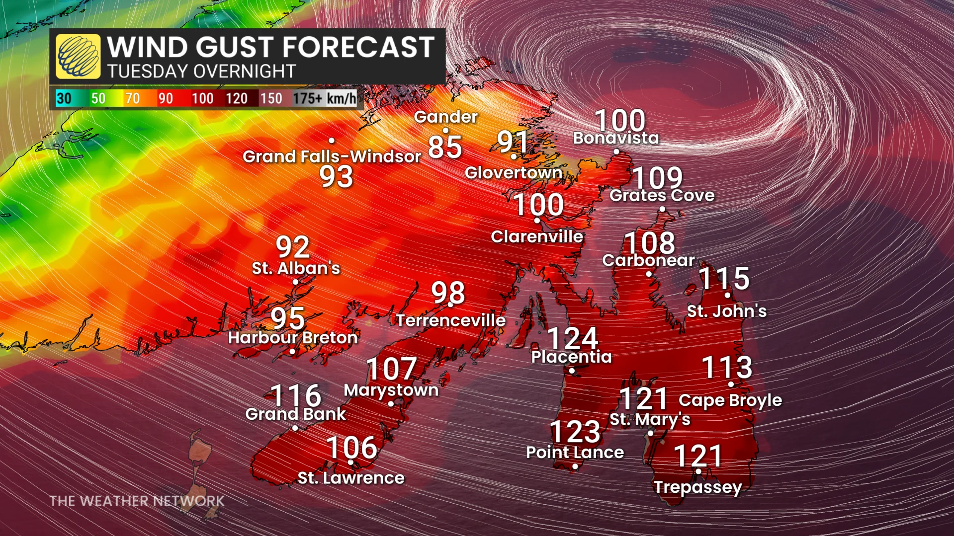
The sub-950 hPa low will cross the Avalon by the pre-dawn hours Wednesday morning, bringing damaging winds (120+km/h), monstrous waves, and high-impact weather conditions to the province.
Meanwhile, potent winds continue across P.E.I. and Cape Breton, N.S., Tuesday overnight, with localized power outages expected.
As the low slowly swirls north of Newfoundland on Wednesday, damaging winds are still occurring and still possible across northeastern sections.

Winds will then slowly drop below warning criteria on Wednesday afternoon and early into the evening.
Stay updated as the storm progresses. Weather conditions will likely present risks for travel and infrastructure in the region.
WATCH: How a 'weather bomb' forms and what it means
Stay tuned to The Weather Network for the latest forecast updates for Atlantic Canada.