Floodwaters force new evacuation orders in Abbotsford as Highway 1 closes
Floodwaters reached Highway 1 in Abbotsford, located approximately 70 kilometres southeast of Vancouver on Thursday night, prompting new evacuation orders for seven properties close to the highway as water began spilling onto the roadway.
Those orders come on top of evacuations already affecting the region. Nearly 460 properties have so far been ordered to leave and another 1,069 properties remain on evacuation alert in Abbotsford.
The city says the flooding has forced the closure of Highway 1 in both directions between Sumas Road and No.3 Rd. Drivers are being asked to avoid the area and check DriveBC for updates as conditions continue to change.
FORECAST: B.C. faces risk of 10- to 20-year flood levels after multi-day rainfall event
Images posted online show long lines of vehicles trapped in congestion along that stretch of the highway. Province says highway traffic will detour via Highway 7.

Vehicles on Highway 1 in Abbotsford on Thursday night after rising floodwaters forced the closure of the route in both directions. (CBC)
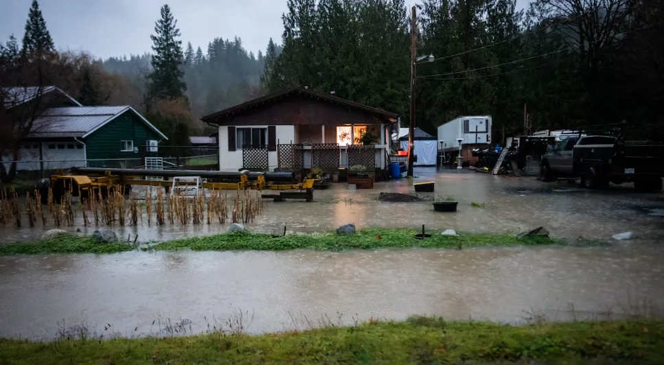
Earlier in the evening, the city said floodwaters in Sumas Prairie and Huntingdon Village are expected to peak within 12 hours. Based on modelling and data from the 1990 flood, water was anticipated to reach Highway 1 late Thursday or early Friday.
As a result of the flooding, the Abbotsford School District says all schools will be closed Friday.
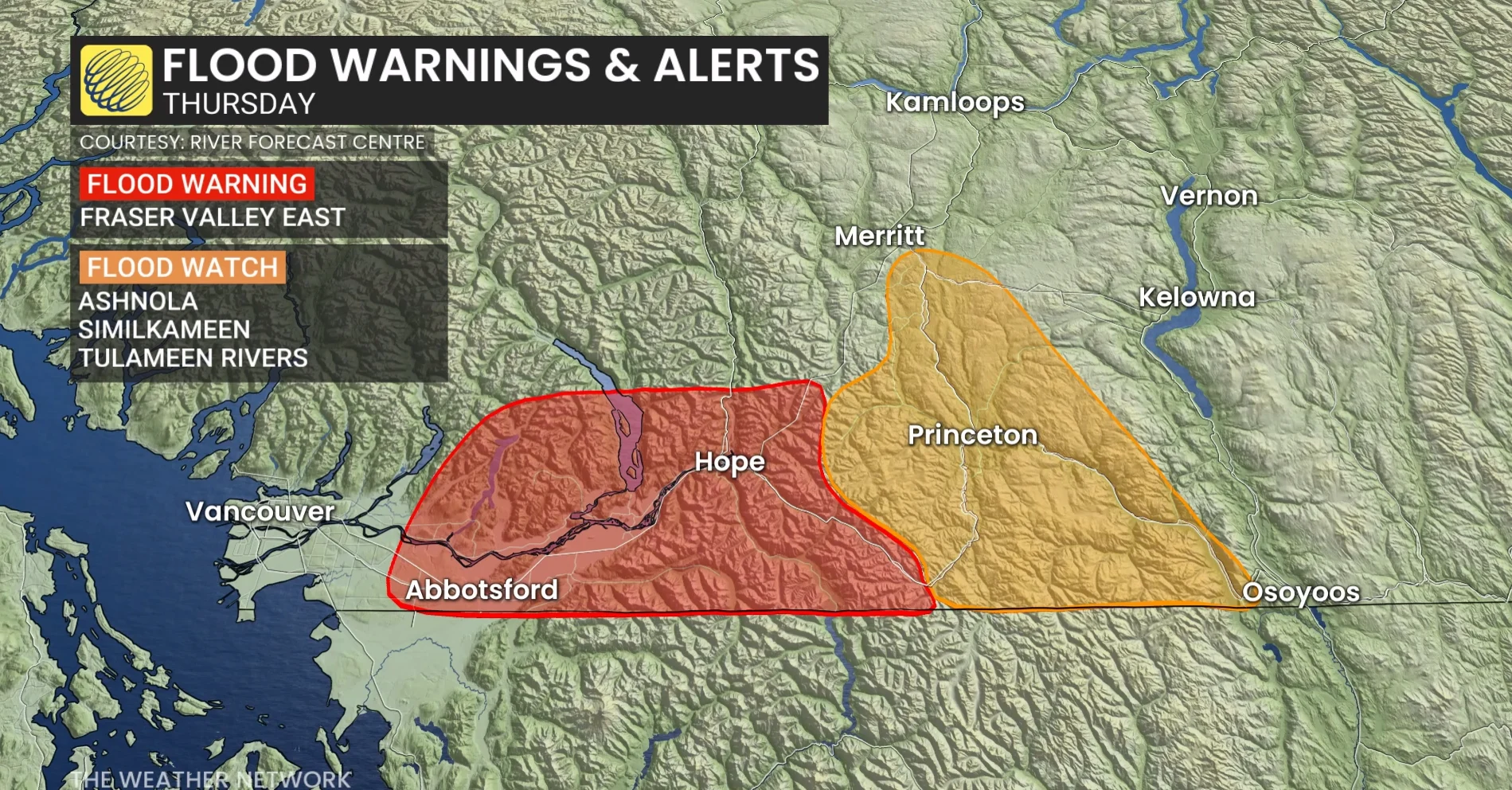
B.C. officials expand flood warnings as rivers continue to rise
Abbotsford declared a state of local emergency Wednesday night, with 371 properties in Sumas Prairie under evacuation order and another 1,069 properties on evacuation alert.
It had expanded its evacuation orders earlier Thursday to include an additional 82 properties in Huntington Village. The Clayburn Village evacuation alert has since been lifted.
The Regional District of Okanagan-Similkameen declared a state of local emergency on Thursday evening as water levels rose in several rivers in its jurisdiction.
The district has further issued evacuation orders for two properties close to the Similkameen River in Princeton, B.C. along Highway 3.
Orders are also in place for the Chopaka electoral area in rural Cawston B.C., an unincorporated community southeast of Princeton. It isn't clear at this time how many properties have been affected by this order.
An evacuation order for the Princeton Municipal Campground is now in place area due to rising water. The district is urging anyone in the area to leave immediately.
Some highways reopen
DriveBC has updated its list of highway closures and reopenings after all major routes out of the Lower Mainland were closed on Wednesday.
DON’T MISS: Atmospheric rivers becoming so intense we need to rank them like hurricanes
The following major highways are still closed as of 9:45 p.m. PT:
Highway 1 from Highway 9 to Hope is closed to eastbound traffic.
Highway 1 near Abbotsford is closed between Highway 11 and No. 3 Rd.
Highway 11 to the Sumas border is closed to commercial traffic in both directions.
Highway 3 from Hope to Princeton is closed due to debris on the highway.
Highway 8 is closed, except for local traffic.
These highways have been fully or partially reopened:
Highway 5 (Coquihalla) between Hope and Merritt has reopened following flooding at Sowaqua.
Highway 7 has fully reopened following a rockslide.
Highway 1 has reopened from Yale to Lytton.
Highway 99 has reopened from Mount Currie to Lillooet.
Up to 150 mm of rain has fallen since Tuesday
Dave Campbell with the B.C. River Forecast Centre says up to 150 mm of rain has fallen since the atmospheric river made its way into the region Tuesday night.
A summary from Environment Canada says 140 millimetres of rain fell at the Hope airport on Wednesday, 125 mm at Cultus Lake and 110 mm at the Chilliwack airport.
Campbell says another atmospheric river is expected to bring more rain to the region, but it was unclear at this point if it would further affect the current flood situation.
Not as severe as 2021 deluge
There have been no reports so far of catastrophic flooding like what was seen in 2021, but officials say that could still occur.
Chilliwack Mayor Ken Popove told CBC's The Early Edition Thursday morning that he had not heard of any major flooding damage in his area.
"Fingers crossed that things are going to be OK for us out here."
Campbell said it will be well into Thursday evening before water levels in Washington state rivers drop enough that they stop pushing excess flow north into Canada.
"The impacts of that could really persist through the evening and into tomorrow," he said.
State of emergency in Washington
Washington state was under a state of emergency Thursday morning from a barrage of torrential rain that has sent rivers flowing over their banks, caused a mudslide to crash down on a highway and trapped people in floodwaters.
Tens of thousands of residents could face evacuation orders there, according to local officials.
After days of seemingly unrelenting heavy rain, Gov. Bob Ferguson declared a state-wide emergency Wednesday night, warning "lives will be at stake in the coming days.”
Some residents have already been ordered to higher ground, with Skagit County, a major agricultural region north of Seattle, ordering those within the Skagit River’s floodplain to evacuate.
Amtrak trains between Seattle and Vancouver have been suspended.
Flood watches and high stream flow advisories are also in place across much of the southern portion of B.C.
WATCH: High water levels as rain creates flooding conditions in B.C.
This article, written by Chad Pawson, was originally published for CBC News.
With files from CBC's The Early Edition and the Associated Press