Heavy snow persists in Quebec, second wave arrives Monday
Portions of Quebec could see up to 30 cm of snow between the two rounds of precipitation into the day Monday
A robust early-season snowfall pushing across Quebec will leave behind a hefty coating to begin the new workweek. Some areas could see up to 30 cm of accumulation by Tuesday morning.
The first wave will continue through Sunday night, followed by a second ‘bonus’ bout of wintry precipitation during the day Monday.
RELATED: Why the first snowfall of the season can catch drivers by surprise
Sunday snow continues into the overnight hours
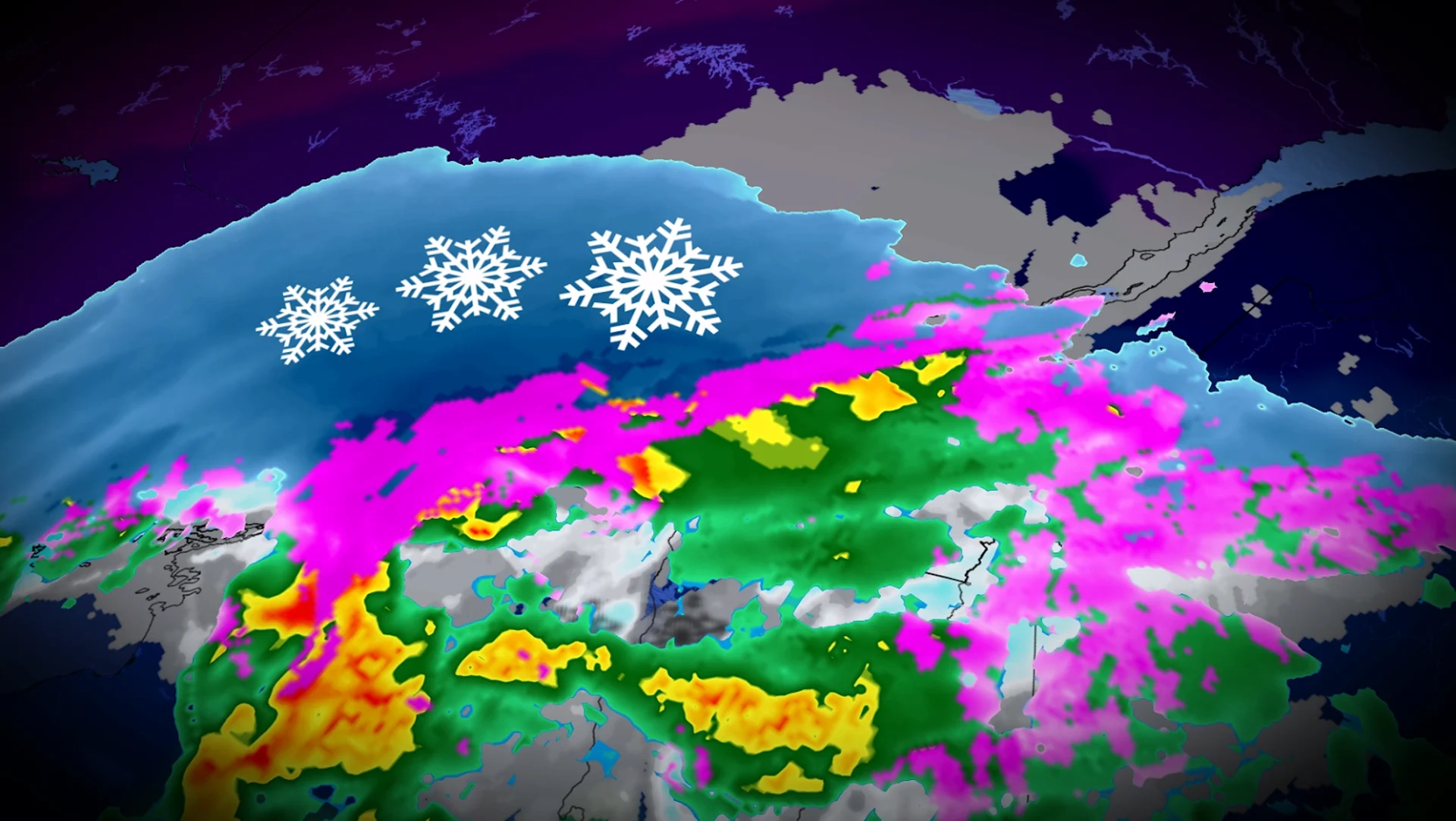
Snow began across much of Quebec during the day Sunday as a low-pressure system pushed east into the region.
The heaviest snowfall will occur through early Sunday evening across Montreal, with precipitation rates approaching 1-2 cm per hour during the heaviest bursts.
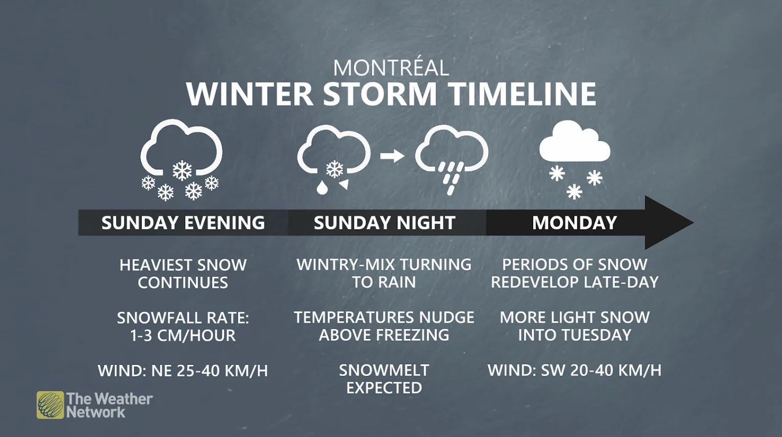
Temperatures are forecast to nudge above the freezing mark in Montreal on Sunday night, bringing a wintry mix and eventual transition to rain through the overnight hours. Montreal will transition back to light snow early Monday morning, with a wintry mix continuing farther northeast.
Most of the Montreal area can expect more than 10 cm of snow, with northwestern sections exceeding 15 cm of accumulation.
Meanwhile, heavy snowfall will persist through the pre-dawn hours Monday for Shawinigan and Quebec City, where blowing snow may reduce visibility at times.
Monday features a second wave of precipitation
A wintry mix—including plain old rain—will develop north of Sorel toward Trois-Rivere and into Quebec City as warmer air is drawn north into the region on Monday.

We’ll see another wave of low pressure lift north into the province, generating a second round of snowfall for much of southern Quebec, including Montreal, Sherbrooke, and Drummondville.
Montreal proper could see 3-5 cm of additional accumulation from this second bout of snow on Monday, with 5+ cm in the Eastern Townships. Saguenay is in line for around 10 cm of snow during the day Monday, with higher totals possible in the mountains north of Quebec City.
Combined, the two rounds of snow will produce 20-30 cm across Saguenay, 15-20 cm in Trois-rivières, 10-15 cm in Quebec City, and around 10 cm in Montreal.
Safety tips for driving in adverse weather
Install winter tires. Winter tires can improve stopping distance by up to 30 per cent in wintry conditions.
Prepare an emergency kit. Include the basics like snacks, first aid kit, flashlights and blankets.
Plan your travel. If possible, postpone trips during active weather and especially freezing rain. Driving is not worth the risk.
Adjust your speed. A gentle reminder that stopping distance increases exponentially as your speed increases.
WATCH: Region by region look at when to change to snow tires
Stay with The Weather Network for all the latest on conditions across Quebec.