Heavy rain hits Ontario ahead of powerful winds, weekend cooldown
Two systems will bring two rounds of rain to Ontario through Friday. By Friday, wind gusts may reach up to 90 km/h, as well, followed by a significant drop in temperatures
September often brings contrasting weather conditions across Canada, with extreme heat gripping Western Canada this week, while southern Ontario experiences an early taste of fall. A cooldown, along with rain and gusty winds, will move into the region.
After rain on Thursday, southern Ontario will see temperatures drop heading into the weekend, with some notably cool mornings ahead.
DON'T MISS: September’s back-to-school tug of war: Summer heat meets fall chill
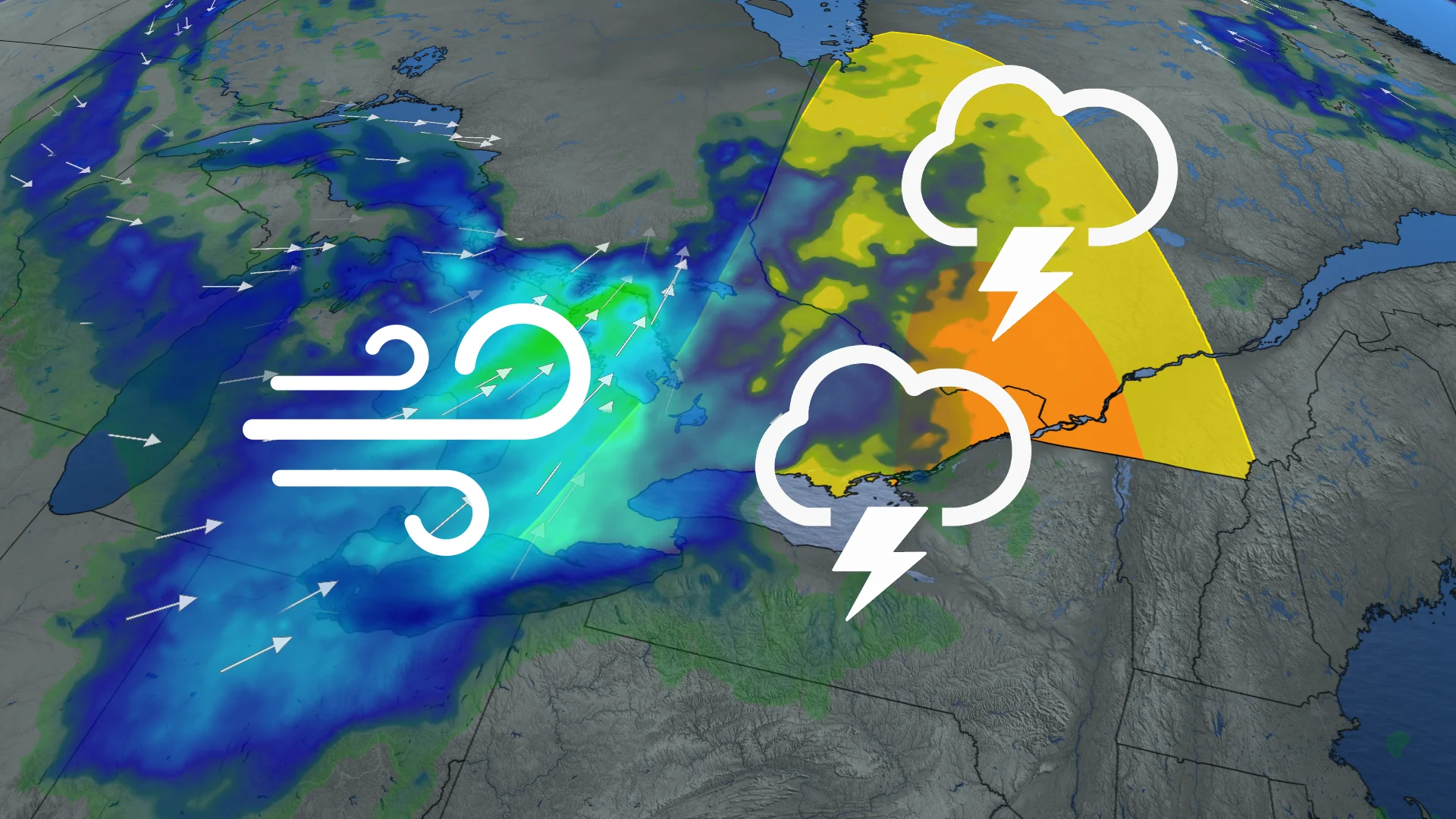
Strong southwesterly winds are forecast to develop Friday as a secondary low-pressure system moves over northeastern Ontario. The strongest wind gusts, reaching up to 90 km/h, are expected along areas near Lake Huron and Georgian Bay.
Be sure to stay weather-aware and prepare for the changing conditions.
Heavy rain hits Thursday
A system over northeastern Ontario is pushing a cold front through southern and eastern Ontario. Rainfall picked up across the Greater Toronto Area (GTA) early Thursday morning, reaching the Ottawa Valley by evening. Heavy downpours and isolated rumbles of thunder are expected.

Northern Ontario may see 50-75 mm of rain, while southern Ontario is forecast to pick up 10-20 mm due to fast-moving showers.
Gusty winds pick up on Friday
The strong low pressure system over northeastern Ontario is driving a secondary low from the Prairies into the province by Friday. This secondary system will bring another round of heavy rainfall to northeastern Ontario.
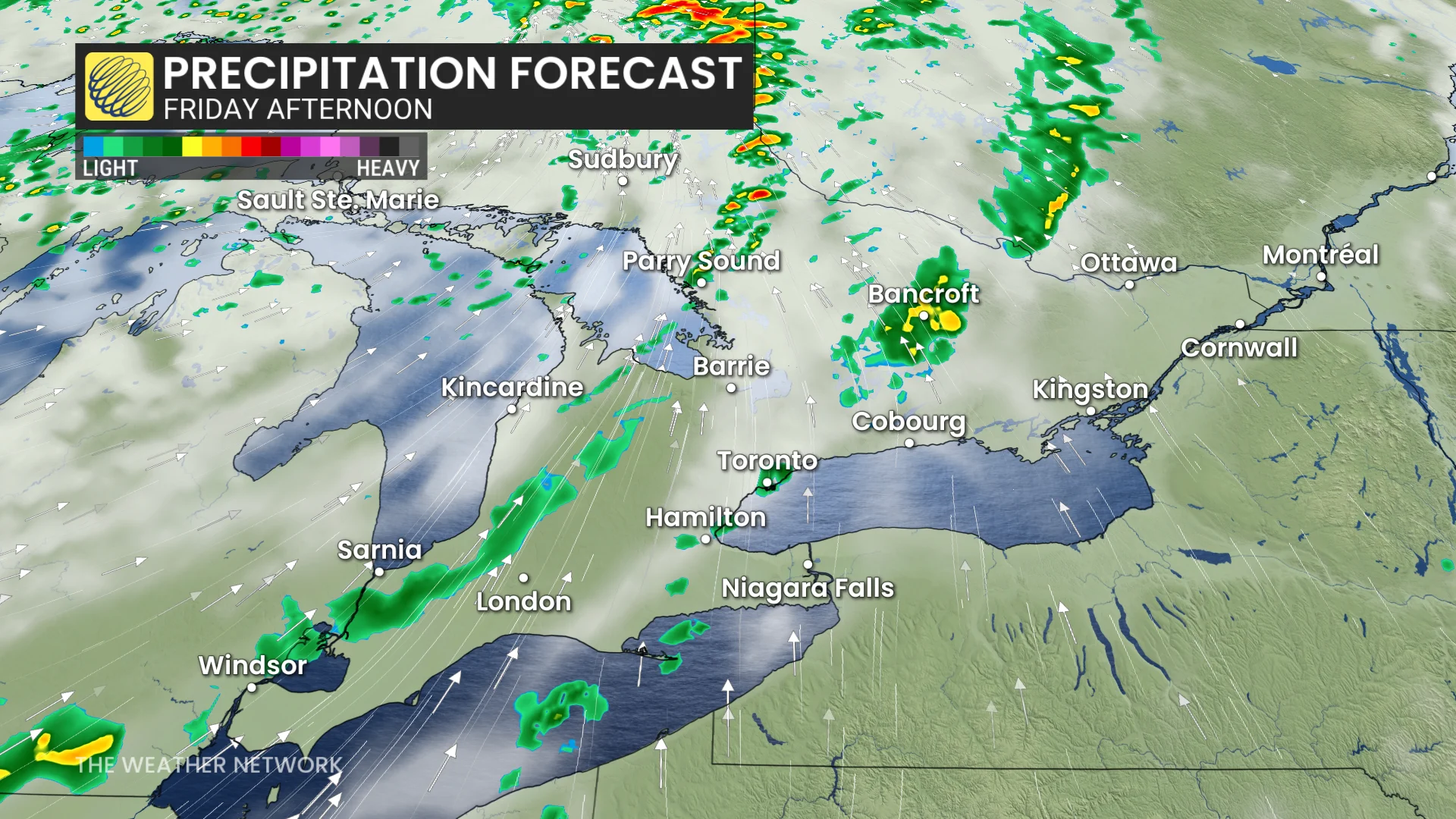
The primary concern, however, will be strong winds across northeastern and southern Ontario. Wind gusts could reach up to 90 km/h along the Georgian Bay shorelines, while widespread gusts between 50-80 km/h are expected across southern Ontario.
Special weather statements are in effect.

On the positive side, the southerly wind flow will help temperatures climb back to seasonal values for this time of year, ahead of another cooldown in time for the week.
DON'T MISS: A typical September sends Canada heat, frost, hurricanes, and snow
Autumnal chill hits in time for the weekend
A large, upper-level low will pull a cold air mass from the north across the province.
By the weekend, daytime highs in the GTA are expected to settle in the mid-to-high teens, accompanied by chilly morning temperatures. These readings will be a few degrees below the seasonal average for early September.

Autumnal weather will continue for most of next week. Temperatures will be several degrees cooler than seasonal, but most of the week will be dry.
WATCH: Canada, what kind of weather is typical in September?
Be sure to check back for the latest weather updates across Ontario.