
Heat relief comes with a multi-day storm risk for parts of Ontario
Ontario is set to receive beneficial rainfall in the coming days, though it will arrive in the form of storms. Multiple rounds of isolated thunderstorms are expected, with the potential for torrential downpours in localized areas
The current heat wave will extend through Tuesday across southern Ontario, with relief arriving mid-to-late week. A cold front is set to move across the region Tuesday night into Wednesday, bringing rounds of showers and thunderstorms.
While the rainfall may provide temporary and localized relief from the ongoing dry and dangerous wildfire conditions, many areas will likely receive less rain than needed to make a significant impact. Storm activity will vary, leading to a range in precipitation totals across the region.
DON'T MISS: Get the latest wildfire news and safety tips to help you stay safe
Fire danger ratings have climbed to extreme levels in several regions, with multiple fires igniting over the weekend in Kawartha Lakes and Bobcaygeon.
Isolated storm risk on Tuesday with hit-or-miss rainfall chances
Weak atmospheric instability is expected to spark isolated thunderstorms across southern Ontario, including the Greater Toronto Area (GTA), by mid-afternoon Tuesday.
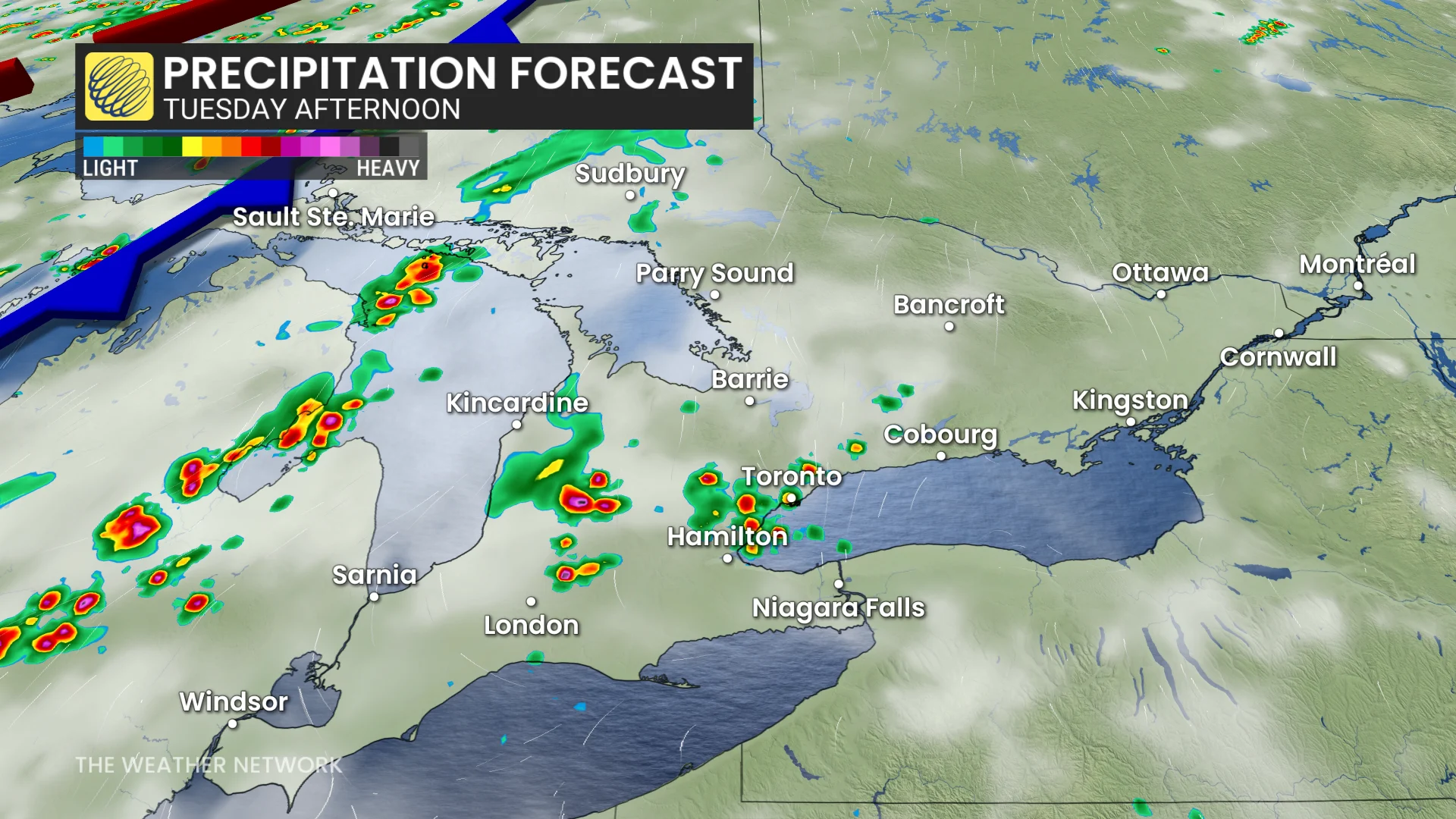
Some storms may produce scattered rainfall in fire-affected areas like the Kawarthas.
High humidity and elevated moisture levels in the atmosphere could lead to torrential rainfall in localized areas.
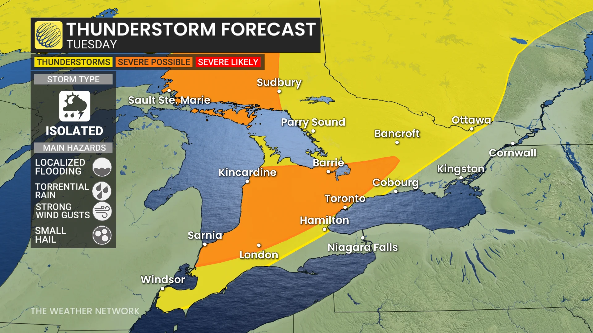
This raises the potential for localized flooding and gusty winds.
Rainfall totals may vary significantly, with over 30 mm possible in the heaviest downpours, while other areas may see little to no precipitation.
More widespread rainfall on Wednesday as temperatures drop closer to seasonal values
A cold front will sweep across southern and eastern Ontario by Wednesday, delivering some much-needed rainfall to the region.
Thunderstorm activity is expected from Windsor through Toronto and into Ottawa late Tuesday night into Wednesday morning.

RELATED: Why nocturnal thunderstorms can be particularly dangerous
By Wednesday afternoon, lake breezes may trigger additional storms in areas like Windsor, Niagara, and parts of the GTA.
Near and east of Ottawa, the cold front could spark stronger thunderstorms.

The cold front may briefly mix wildfire smoke closer to the surface, potentially reducing air quality for a short period.
DON'T MISS: Summer in Canada steams ahead in August, with a few hints of fall
By Thursday and Friday, daytime highs are expected to be more comfortable, reaching the high 20s, though humidity will still make it feel like the low 30s.
Looking ahead, rain chances will remain limited in the long term, though showers are possible this weekend.
Closely eyeing Tropical Storm Erin
Temperatures across Ontario are forecast to drop significantly next week, with a few days potentially falling below seasonal averages.
The trajectory of Tropical Storm Erin will play a key role in shaping the amplitude of the trough over the region later in the week. This could influence both the intensity and duration of the cooler weather period.
DON'T MISS: Tropical Storm Erin has formed in the Atlantic, and will be one to watch
Further updates will provide clarity as the situation develops.
Be sure to check back for the latest weather updates across Ontario.