Humberto on the board as Gabrielle targets Azores with hurricane impacts
As the Azores prepare for effects from Hurricane Gabrielle, the Atlantic Ocean wasted no time in creating another named storm: Humberto, which also may become a hurricane this weekend.
With the Azores bracing for Hurricane Gabrielle impacts, the Atlantic Ocean has another named storm at play.
According to U.S. National Hurricane Center (NHC), Tropical Storm Humberto came to life in the central-tropical Atlantic Ocean on Wednesday. Like its northern counterpart, Gabrielle, Humberto is also anticipated to become a hurricane in the near future.
DON’T MISS: Study urges forecasters to adopt new hurricane intensity scale
With Humberto in the wings, forecasters are also keeping a close eye on a third area of disturbance west of the aforementioned named storm that could see development over the next week.
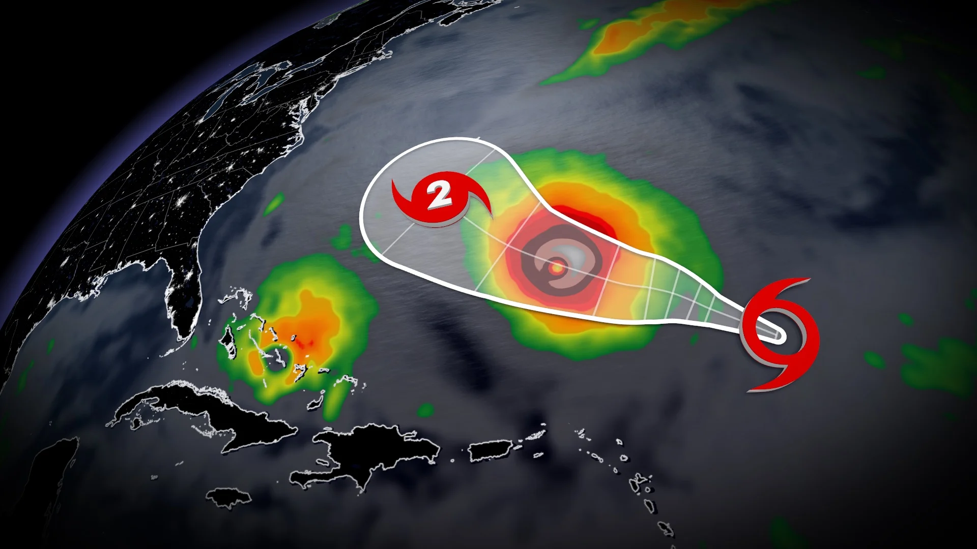
Gabrielle threatens the Azores with hurricane impacts
Hurricane Gabrielle is expected to track over the Azores Thursday and Friday, prompting the NHC to issue hurricane warnings.
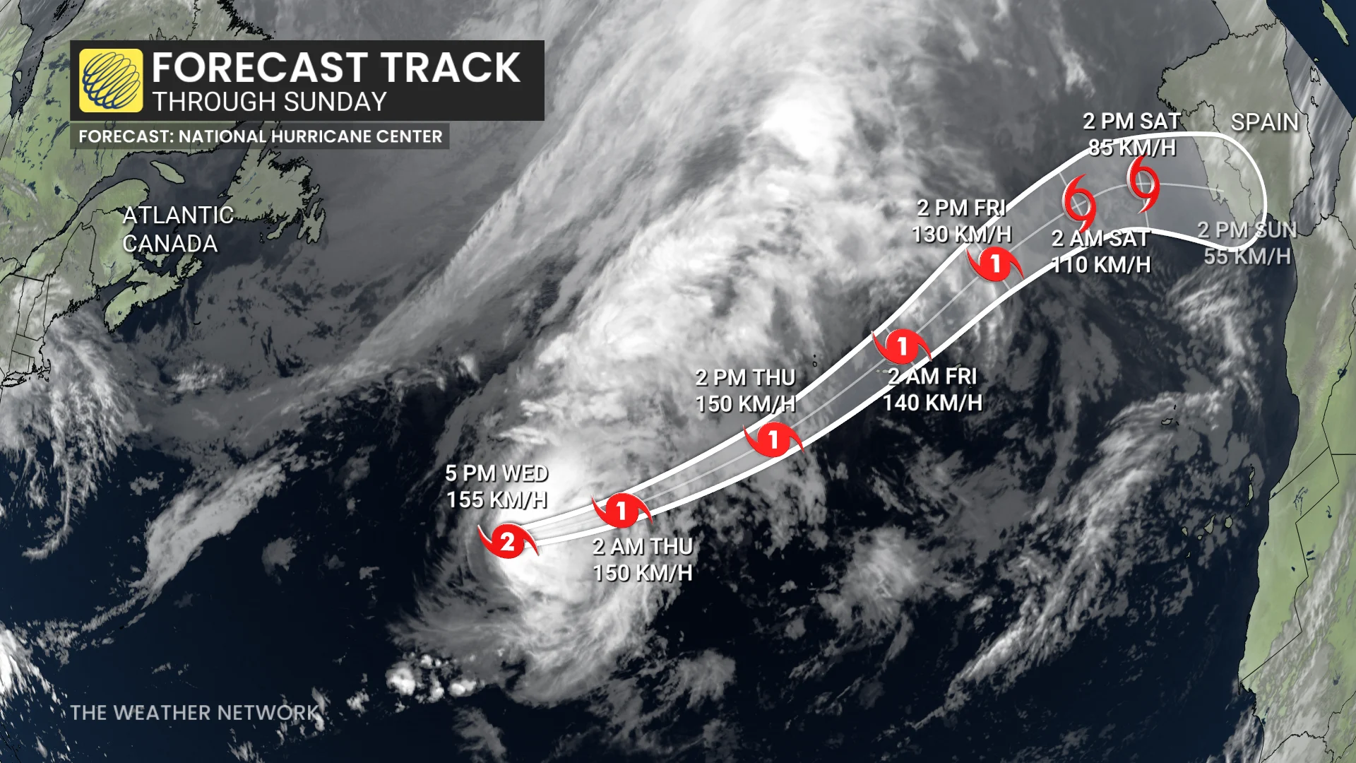
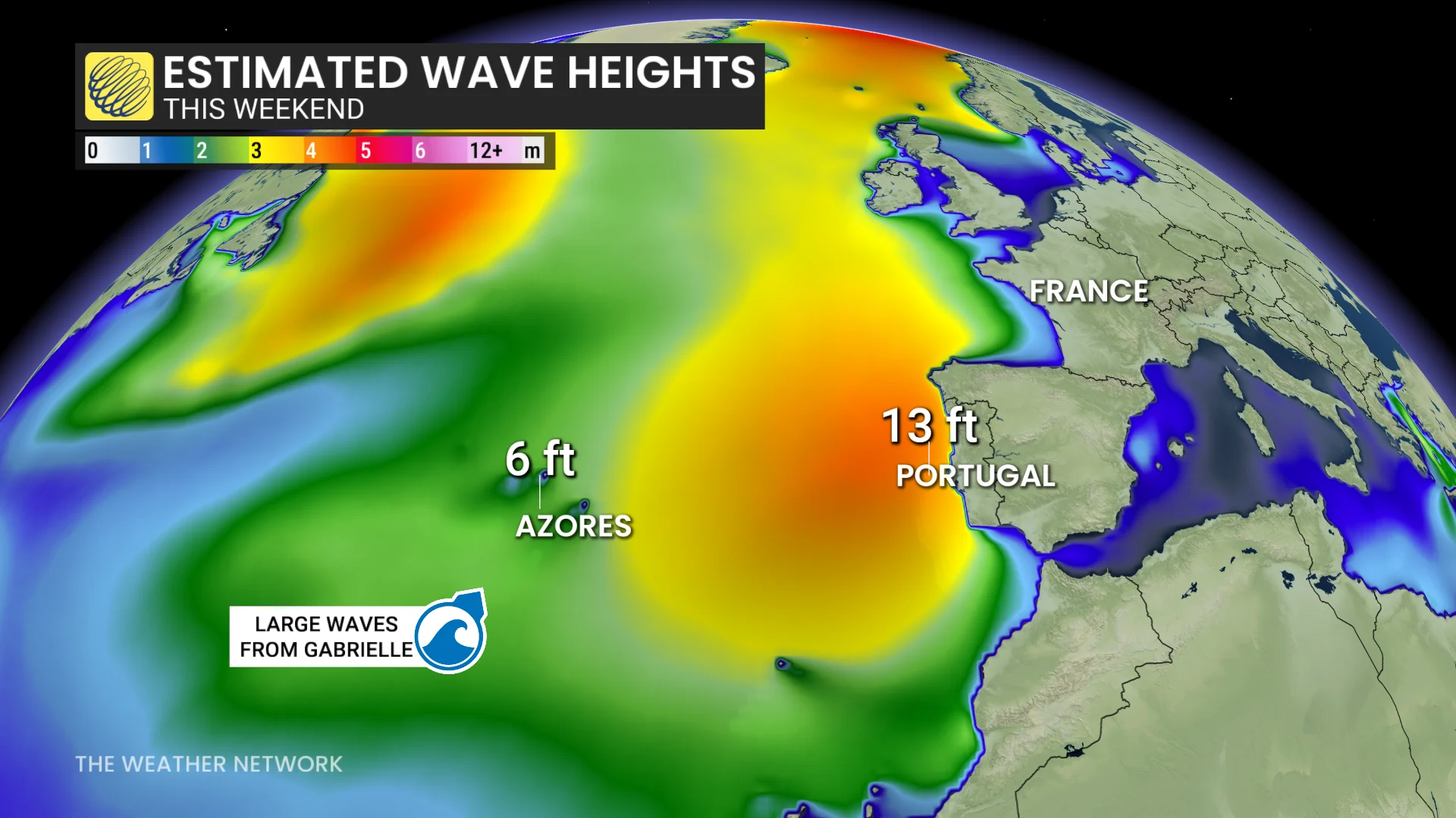
The forecast track may take it close to Portugal, with large waves forecast this weekend along the coast.
Maximum, sustained winds are near 155 km/h with higher gusts. Some weakening is forecast during the next few days, but Gabrielle is forecast to be at hurricane strength when it passes through the Azores.
Dangerous storm surge is anticipated to cause significant coastal flooding in areas experiencing onshore winds, warns the NHC. This surge will be accompanied by large, destructive waves.
From Thursday through Friday morning, Gabrielle is expected to bring 75 to 125 mm of rain to the central and western Azores. Meanwhile, outer bands of the storm could deliver 25 to 50 mm of rainfall across the eastern Azores during the same period.
Over the past 50 years, only three hurricanes have passed through the Azores, either making landfall or tracking between the islands. All were Category 1 storms:
Emmy on Sept. 3, 1976
Gordon on Sept. 20, 2006
Gordon on Aug. 20, 2012
Humberto expected to see more strengthening in the Atlantic
Tropical Storm Humberto was named Wednesday evening after strengthening through the day. A west-northwest to northwest motion is expected over the next several days with a slower forward speed.
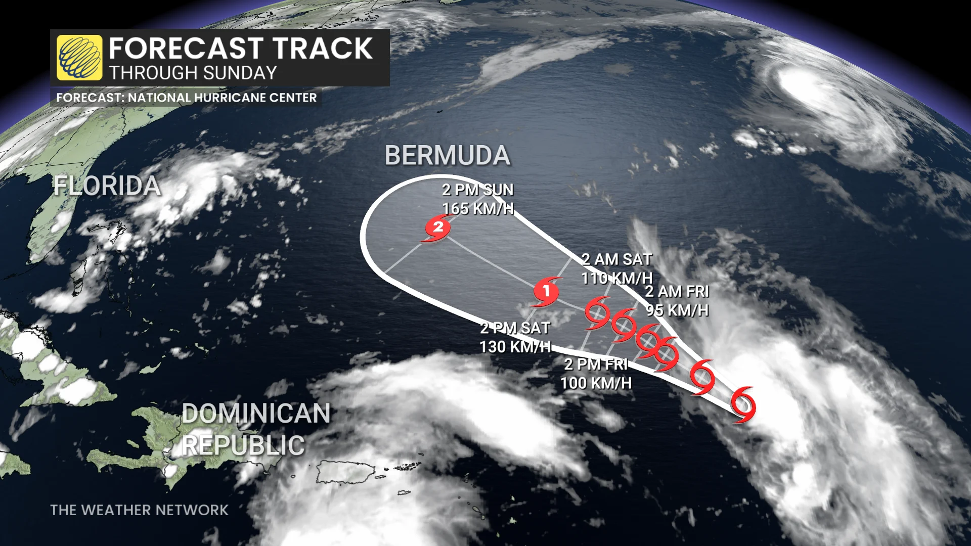
Maximum, sustained winds are currently near 65 km/h with higher gusts. Steady strengthening is forecast during the next several days.
By the weekend, Humberto is forecast to strengthen and become a hurricane as it approaches south of Bermuda.
Steering factors include:
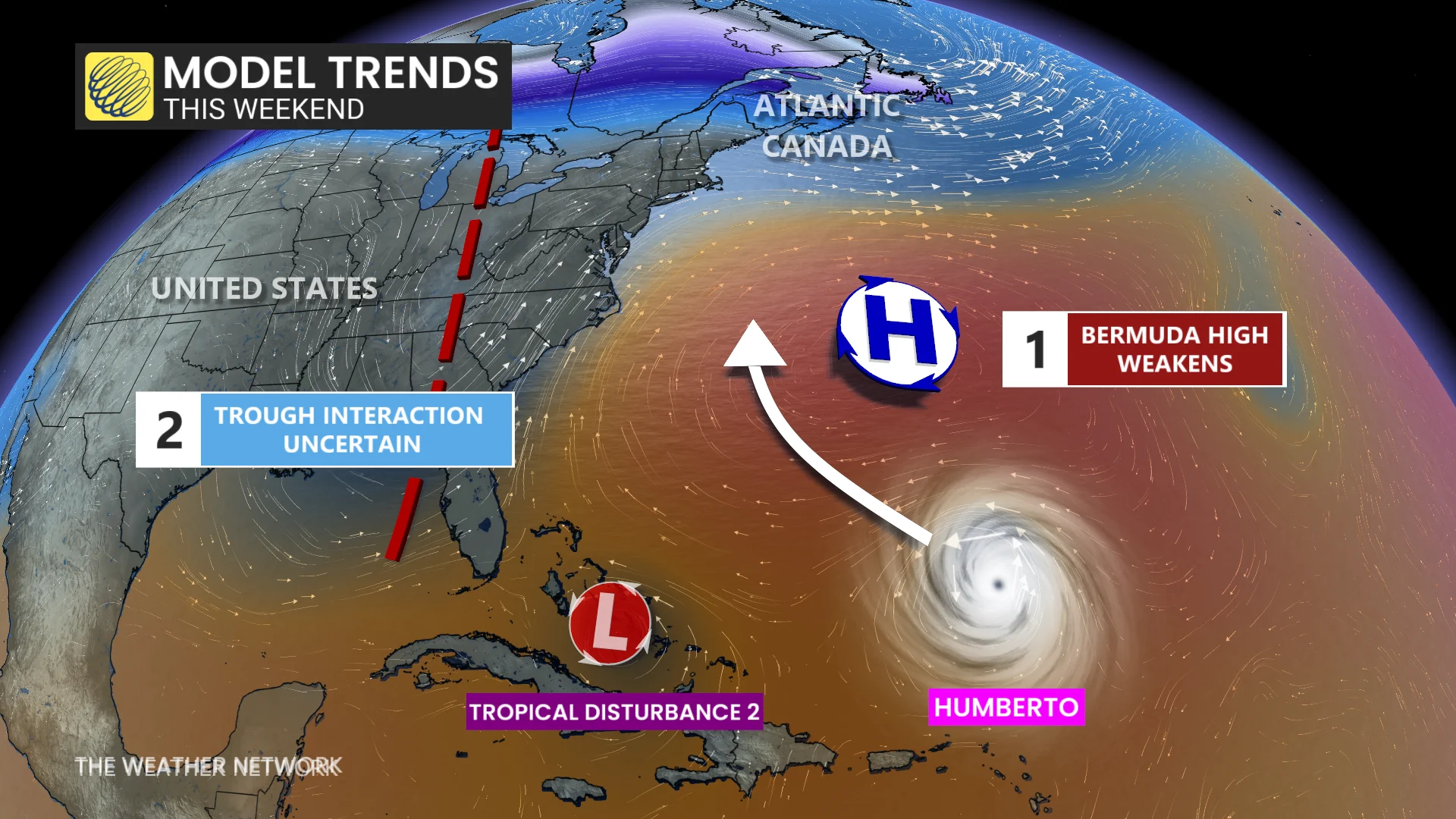
There is much uncertainty where Humberto will track beyond the weekend
A high over Bermuda will weaken, allowing the storm to approach from the south
Another tropical disturbance, still unnamed, in close proximity and could alter path
Forecasters will need to watch the timing and interaction of Humberto with a trough over the U.S. East Coast.
Swells from Hurricane Gabrielle will continue to impact Bermuda, U.S. East Coast, and Atlantic Canada
"Swells generated by Gabrielle will continue to affect Bermuda over the next couple of days, and the U.S. East Coast from North Carolina northward and Atlantic Canada over the next day or so," the NHC says. "These swells are expected to produce life-threatening surf and rip current conditions."
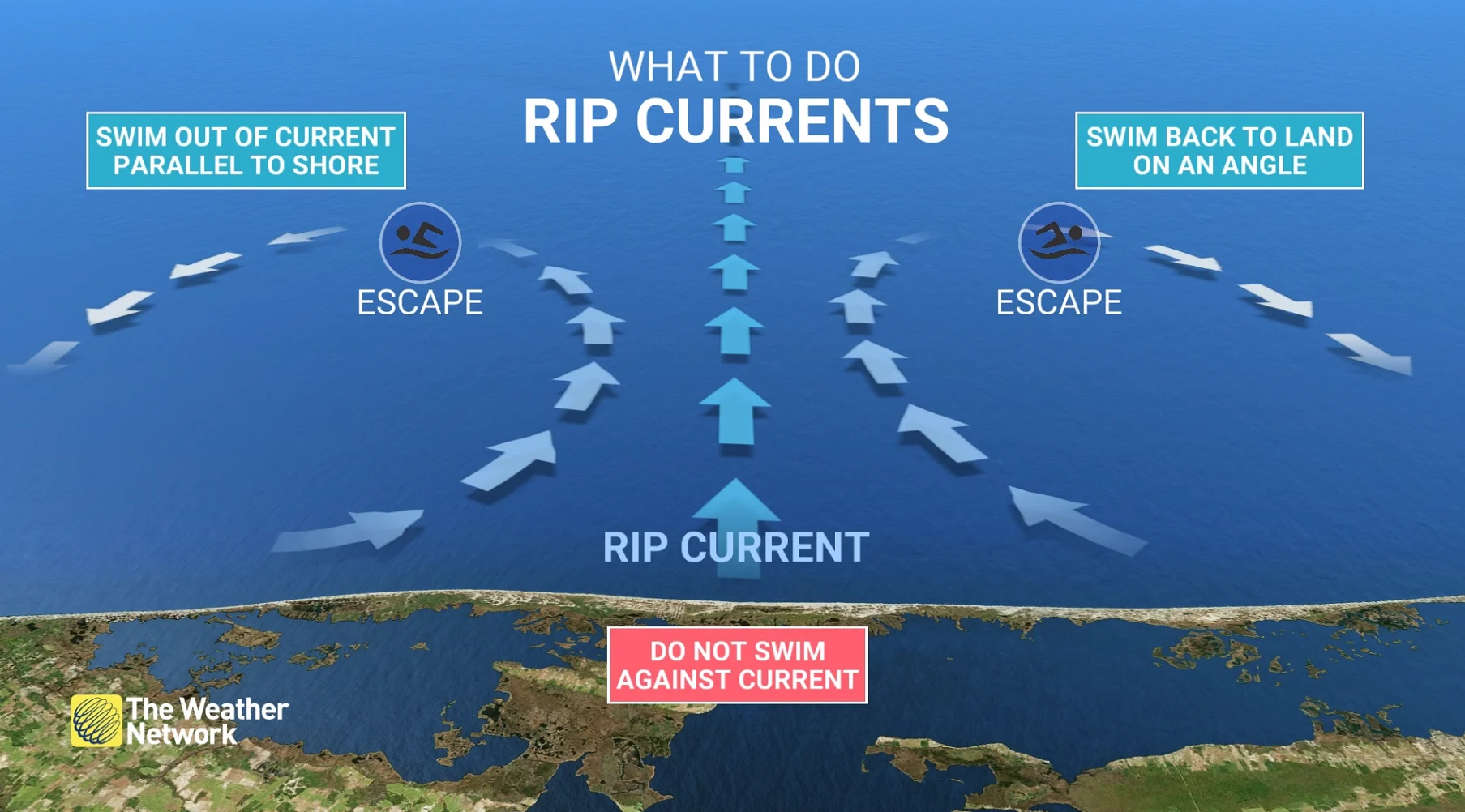
If you’re ever caught in a rip current and you can’t swim, don’t panic. Calmly signal for help and tread water until assistance arrives. Folks experienced in swimming should swim parallel to the beach until out of the rip current, then swim directly back to shore.
Eyes on one additional tropical system
Looking ahead, another areas of interest is approaching the U.S. coastline as we head into next week.
Although it is currently disorganized, atmospheric conditions are expected to become more favourable for storm development and strengthening. It has a low chance of development in two days, but an 80 per cent chance of formation in the next week.

There is ongoing rain and wind over the Dominican Republic and Puerto Rico. It is forecast to become more organized as it nears the Bahamas this weekend.
MUST SEE: What does a hurricane's ‘cone of uncertainty’ mean?
Forecasters and communities along the U.S. Eastern Seaboard region should closely monitor the system as it evolves.