First snowfall this fall for Calgary, but it comes with a catch
Calgary folks may wake up to a dusting of snow on Sunday morning as a cold front sends temperatures plummeting and the snowflakes flying in parts of Alberta
Snow, rain, gusty winds and even some thunderstorms are on the menu for Thanksgiving weekend on the Prairies.
For Alberta, a major cooldown and snowfall will be the main course served, with Calgary in the mix for possibly seeing some snowflakes Saturday night into early Sunday morning.
DON’T MISS: An abrupt transition to winter? Check out Canada’s winter sneak peek!
While no major accumulations are expected for Calgary, it will be the first snowfall of the fall, so many drivers may be caught off guard. Travel could prove difficult in spots as roads will be slippery.
Snowfall on the table for Calgary...with a catch
Alberta is first in line to experience the rapid temperature drop on Saturday as our cold front moves through the province, allowing for snow to fall.

The catch? It’s not a uniform snowfall, and amounts will vary across city limits.
In true fall fashion, Calgary’s first snow of the season will arrive, beginning as a cold rain late Saturday afternoon before flipping to wet snow into the evening.
The changeover will sweep west to east across the city between 6 p.m. to 8 p.m. Saturday, with the heaviest snow expected in the higher west-end neighbourhoods like Aspen Woods, Signal Hill, and the University of Calgary area, where locally up to 5 cm may accumulate by early Sunday morning.
Specific timing
5 p.m. Saturday
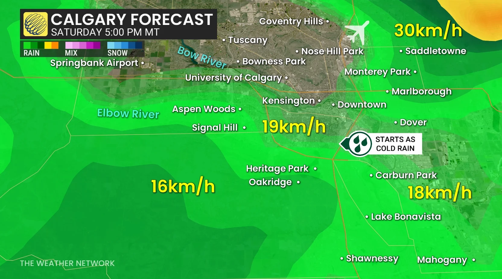
Light rain spreads across most of the city, with just wet roads at this point.
7 p.m. to 8 p.m. Saturday
The rain-snow line cuts straight into the heart of Calgary––starting in the west end (Aspen Woods, Signal Hill, Springbank Airport)

This is the key changeover, and after 8 p.m., downtown Calgary is forecast to transition to a wintry mix. It will still be raining towards Carburn Park, Lake Bonavista, and Mahogany.
10 p.m. onwards
All wet snow across Calgary, and a general light intensity (less than 1 cm/hour). Flurries taper from west to east, and precipitation begins to ease after the midnight hour, wrapping up quickly through the overnight.

Localized Calgary snowfall amounts
Heaviest accumulation zones tend to line up with the western half of the city, across higher terrain. Aspen Wood, Signal Hill, Springbank Airport, University of Calgary, and Nose Hill have the greatest odds to pick up 5 cm.
Central areas like Kensington and Bowness are forecast to get a few cm, while downtown and southeast are likely to accumulate less than 3 cm, with less sticking and a faster melt.

Early-season snowfalls come with higher uncertainty, with temperatures hovering just above freezing when the wet snow begins. Snowfall totals will vary widely across the city, as it’s elevation-dependent.
Thumbnail courtesy of City of Calgary Transportation webcam.
Stay with The Weather Network for all the latest on conditions across the Prairies.