Dangerous, major Hurricane Melissa turns to Cuba with disastrous impacts
Despite dropping down to a Category 3 hurricane, Melissa remains a powerful and threatening storm that could bring destructive impacts to Cuba when it makes a secondary landfall
Stay up-to-date with all hurricane developments on The Weather Network's tropical storm hub page.
Weather Highlights:
Hurricane Melissa made landfall near New Hope, Jamaica, on Tuesday afternoon as historic Category 5 storm. It is now a Category 3 hurricane
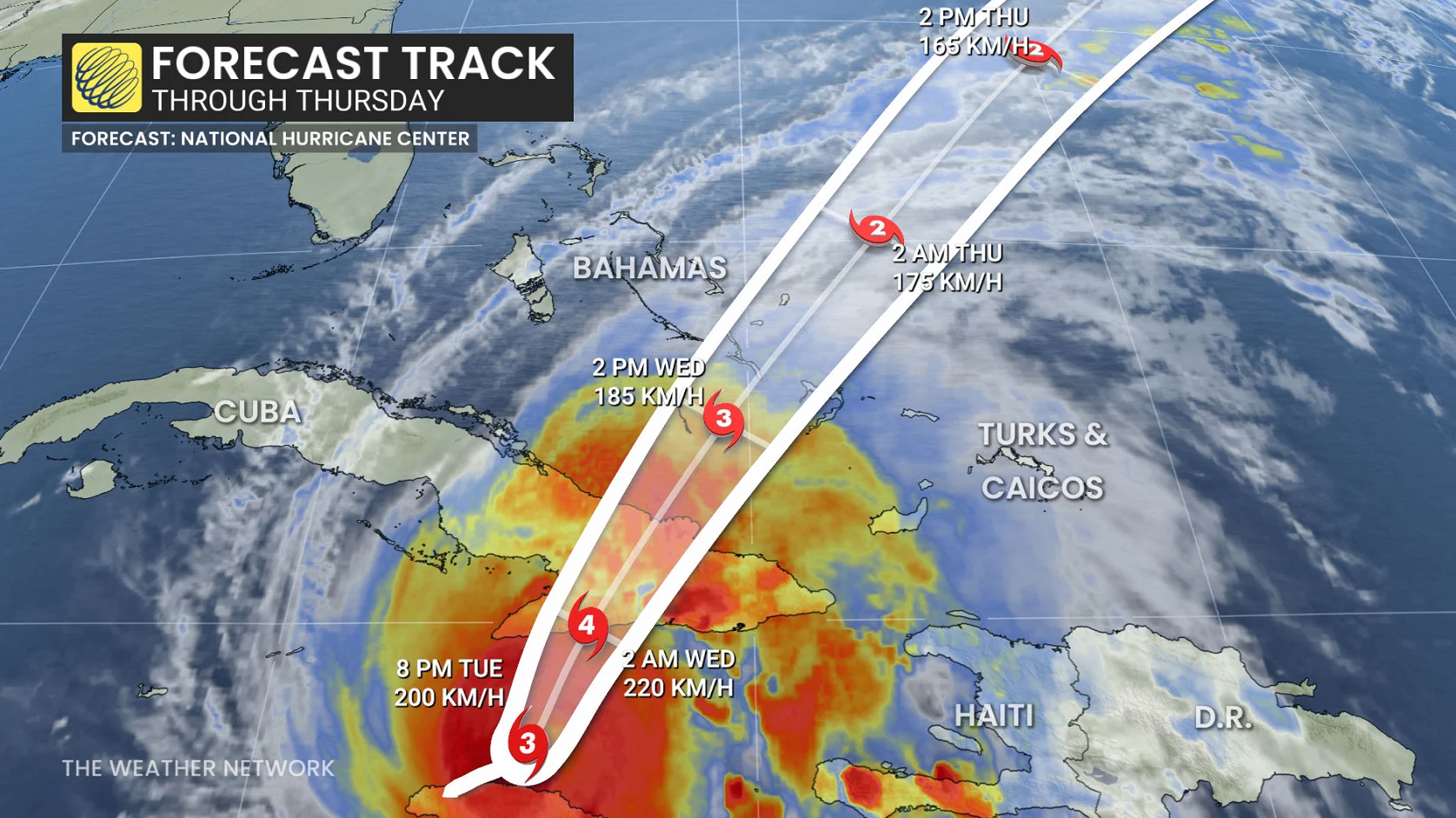
A second landfall expected in eastern Cuba Tuesday night or early Wednesday. Severe impacts include catastrophic rainfall, flash flooding, and landslides
Eastern Cuba faces rainfall totals exceeding 500 mm, with local amounts up to 635 mm, and storm surges of 2.43 to 3.65 metres or higher, threatening low-lying coastal areas near and east of landfall.That will result in flash flooding in landslides
Storm surge of 1.52 metres to 2.43 metres above normally dry ground is possible in the southeastern Bahamas on Wednesday
Hurricane watch issued for Bermuda
Swells generated by Melissa will impact parts of Hispaniola, Jamaica, eastern Cuba, Cayman Islands, Bahamas, Turks and Caicos, and Bermuda, causing dangerous surf and rip currents in the coming days.
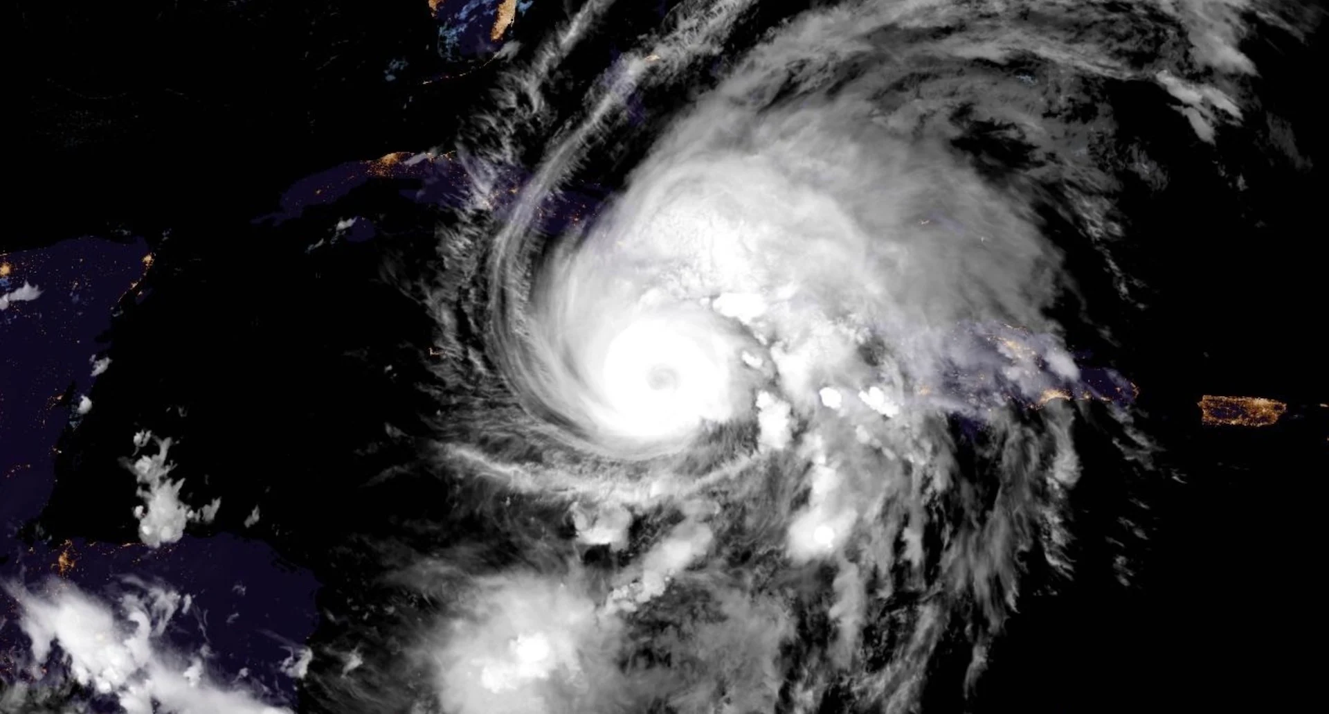
Hurricane Melissa continues to meander across the northern Caribbean, delivering damaging winds, catastrophic flash flooding, and life-threatening storm surge, especially in Jamaica.
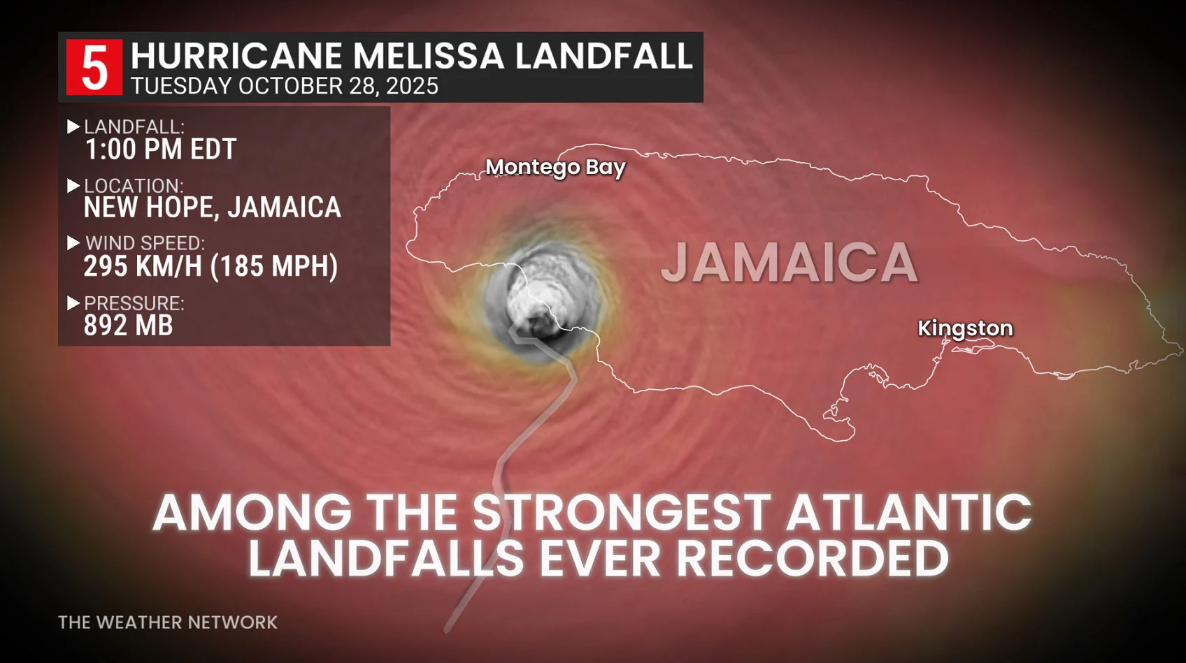
The storm is the strongest recorded globally in 2025. Melissa made landfall as a dangerous and historic storm near New Hope, Jamaica, around 1 p.m. EDT on Tuesday afternoon.
The pressure at landfall was tied for the strongest pressure at landfall for any Atlantic hurricane on record (tying the Labour Day 1935 landfall in the Florida Keys at 892 mb).
Maximum, sustained winds have since dropped from 295 km/h to 205 km/h with subtle weakening from land interaction, according to the 8 p.m. Tuesday update from the U.S. National Hurricane Centre (NHC).

Melissa weakened to a Category 3 on Tuesday evening, but is forecast to remain as a major hurricane as it approaches eastern Cuba. A second landfall for Melissa is forecast for Tuesday night or early Wednesday morning in eastern Cuba.
_WATCH: Hurricane Melissa brings chaos to the Caribbean
Eastern Cuba faces rainfall totals of 200 mm to 500 mm, with local amounts up to 635 mm. The likely result will be life-threatening flash flooding and widespread landslides. Storm surges of 2.43 to 3.65 metres, or higher, are predicted near and to the east of where the centre of Melissa makes landfall.
Melissa is anticipated to bring additional rainfall totals of 150 mm to 300 mm in Jamaica, with isolated areas near 750 mm over mountainous terrain, potentially triggering more catastrophic flash flooding and landslides. Storm total amounts will vary from 300 mm to 600 mm.
On the northwest coast of Jamaica, near Montego Bay, there is the possibility of 0.60 metres to 1.21 metres of storm surge above ground level. Storm surge flooding on the southern coast of Jamaica should subside late Tuesday night.
Storm surge of 1.52 metres to 2.43 metres above normally dry ground is possible in the southeastern Bahamas on Wednesday, and 0.60 metres to 1.21 metres above normally dry ground in the Turks and Caicos Islands on Wednesday.
For the Turks and Caicos, rainfall totals of 25 mm to 75 mm are expected. Heavy rain may begin to affect Bermuda Thursday night.

DON'T MISS: Canadian impact? All eyes on Hurricane Melissa after its Jamaica landfall
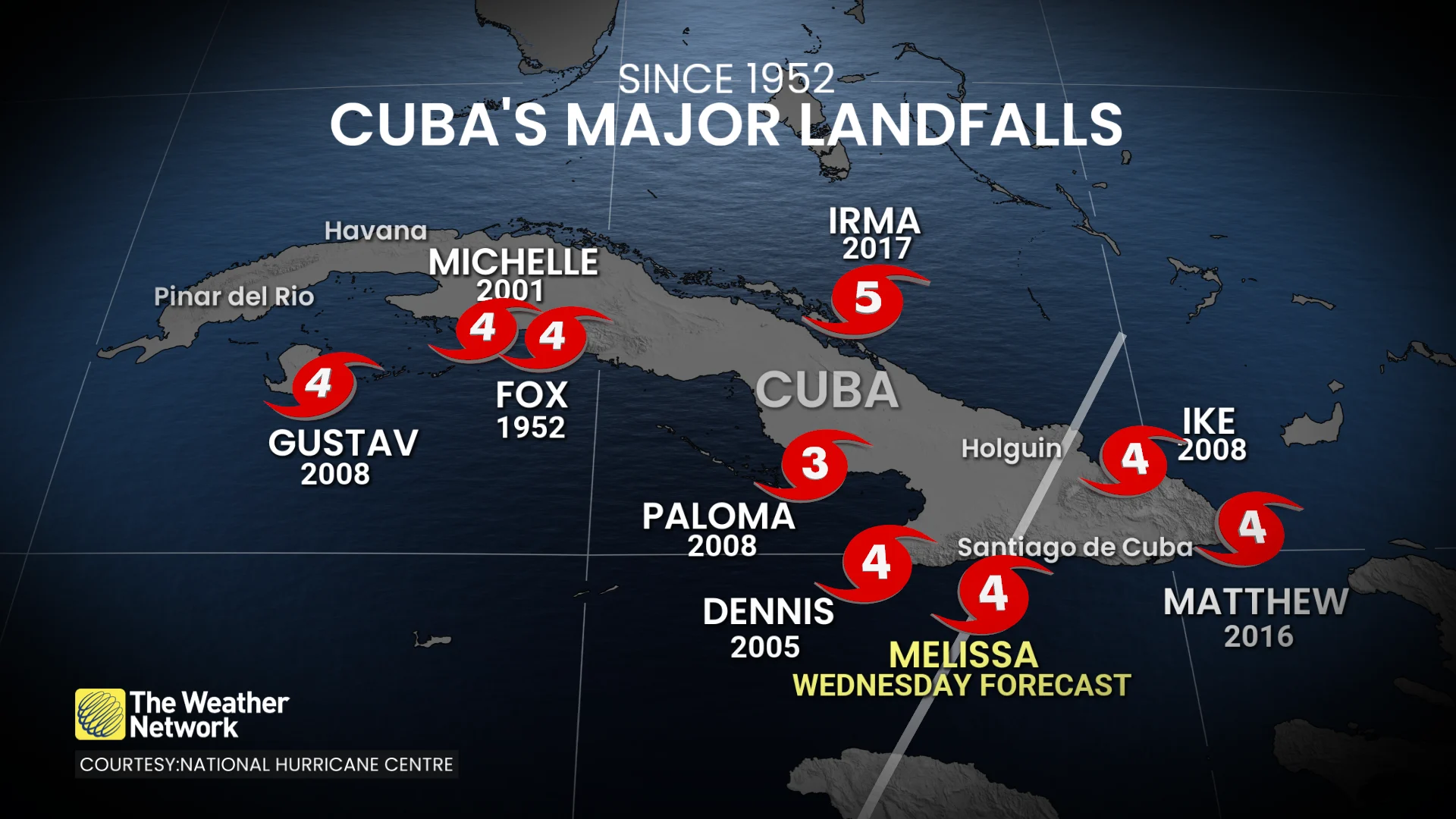
Cuba has experienced several Category 4 and 5 hurricane landfalls since the 1950s, but none have tracked directly through the southeast as Hurricane Melissa is projected to do. Santiago de Cuba is expected to face the most significant impacts from the storm.
Hurricane conditions are expected in the southeastern and central Bahamas on Wednesday. Tropical storm conditions, heavy rain and storm surge are expected, and hurricane conditions are possible, in the Turks and Caicos Islands on Wednesday.
On the forecast track, the core of Melissa is expected to move across the southeastern or central Bahamas later on Wednesday.
All storm preparations should be completed by Tuesday night.
The Meteorological Service of Bermuda issued a hurricane watch on Tuesday. Hurricane conditions are forecast to begin Thursday or Thursday night.
The southeastern Bahamas are forecast to receive 125 mm to 250 mm of rain, causing flash flooding through Wednesday.
Swells from Hurricane Melissa are expected to impact Hispaniola, Jamaica, eastern Cuba, the Cayman Islands, the Bahamas, Turks and Caicos Islands, and Bermuda in the coming days, creating life-threatening surf and rip currents.
Thumbnail courtesy of NOAA.