Abrupt transition to winter: Canada’s 2025-26 winter sneak peek

It’s been an exceptionally warm start to fall across many parts of Canada, but will this trend linger into winter 2025-26? Our preliminary forecast below highlights some key factors that will influence winter weather patterns ahead.
It’s hard to believe that we are rapidly approaching the time when most of Canada’s population typically sees their first flakes of the season!
So far, fall has felt more like summer across most of Canada, especially from the Rockies to the Maritimes.
Below is the temperature anomaly map since mid-September, with the various shades of orange and red highlighting the widespread, warmer-than-normal temperatures. This period has seen numerous record-high temperatures, including a few all-time October records in several provinces.

So now the question is, how long will it last?
Early-winter temperature pattern
We are already seeing warning signs in the global jet pattern that the mild pattern won’t survive all the way through the end of autumn.
October will still provide periods of warmer-than-normal temperatures, but there will be some notable interruptions with quick shots of colder weather, which will help to prepare us for what is to come.
During the month of November, we expect a rather abrupt transition into the start of winter. The exact timing is still uncertain, but once the warm pattern breaks, we expect near-normal and, at times, colder-than-normal temperatures will stick around for much of December.

This graphic represents the temperature pattern expected for early winter. It is not a representation of the winter pattern as a whole. (The Weather Network)
This should help ski areas kick off the season on schedule, but for those with travel plans during the weeks leading up to the holidays, it may be wise to pay a little extra attention to the forecast.
Will that be the start of a long cold winter for Canada? To help answer that question, we need to dig deeper into the key pattern drivers for the upcoming season.
Winter pattern drivers
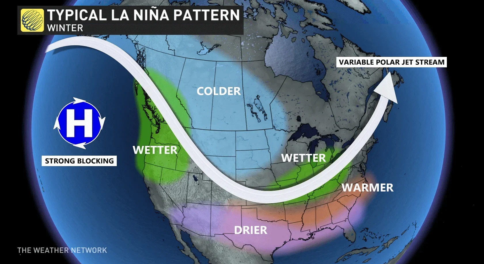
A weak La Niña pattern is expected for the upcoming winter. What does La Niña mean for winter across Canada? If you do a quick search on that question, you will likely see a graphic that resembles the following:
RELATED: La Niña returns, but this will be the key driver of Canada’s winter
During some La Niña winters, frigid conditions have been concentrated in Western Canada (as shown in the graphic above), while Eastern Canada has experienced milder winters. This scenario is more common.
However, there have been several La Niña winters (especially the years with a weaker La Niña), where the cold has been more focused across Eastern Canada.
Previous La Niña winters have also featured a wide range in the persistence of the cold.
Several La Niña winters have nearly run the table with colder-than-normal conditions dominating most of the season. However, other La Niña events have featured flip-flopping patterns through the winter, with very mild temperatures taking over the national pattern for several weeks at a time.
To help determine which flavour of La Niña winter will show up this year, we are looking at other variables that will influence the jet stream pattern.
It appears that the exceptionally warm water temperatures in the North Pacific will hold the key to how the rest of the winter unfolds.
Just a few weeks ago, ocean water temperatures were much warmer than normal across the entire North Pacific Ocean.

Warmer-than-normal ocean temperatures in the circled area are usually associated with a blocking jet stream pattern that unleashes frigid Arctic air across much of Canada, especially from the Prairies to Quebec.
However, such warm-temperature anomalies across the entire North Pacific also bring the potential for extended thaws. Any time the blocking jet stream pattern breaks down, exceptionally mild Pacific air would have the opportunity to flood across the country and bring a thaw to southern areas.
To further complicate things, we have seen significant changes in the North Pacific over just the past few weeks. Here is where things stand now:

Note that while the entire North Pacific is still quite “warm,” the warm anomalies have really started to fade to the west of B.C. and south of Alaska, with the warmest water farther to the west.
If this trend continues, that would shift the focus of the frigid winter weather back into Western Canada, and it would reduce the potential for a prolonged, national thaw. However, areas from the Great Lakes to the Maritimes could still see periods of mild weather surging north from the eastern U.S.
There are several other variables that we are closely watching that influence the behaviour of the polar vortex, which will also dictate the frequency and severity of our cold snaps.
Preliminary look at the temperature pattern for winter 2025-26
Putting everything together, here is our first look at the national temperature pattern that we expect for December, January, and February.

This is a preliminary outlook. The forecast will continue to be fine-tuned in the weeks ahead. (The Weather Network)
We expect that most of Canada will see near-normal temperatures or colder-than-normal temperatures overall. The exceptions are much of Atlantic Canada and parts of northwestern Canada. However, even across these regions, winter is not cancelled—there will still be periods of high-impact winter weather.
Keep in mind that this forecast is an overview for a three-month period and that individual weeks will look quite different at times. We expect that all of southern Canada will see a significant stretch of milder weather during the heart of the season.
The dominant storm track is expected to be into the Great Lakes region and up the St. Lawrence. We also expect an active storm track at times into the B.C. coast.
As we approach winter, we will be interested to see whether La Niña is officially declared. However, the subtle difference between a weak La Niña or a neutral pattern that comes up just short of La Niña criteria won’t be critical to how the winter plays out.
The North Pacific truly is the wild card that will dictate how the upcoming winter will unfold, and that is where the focus of our research will be during the weeks leading up to our final winter forecast, which we will release on Nov. 26.