
Spring, you're fake news. Ugly pattern into mid-May

Feeling cheated by this spring weather? Spoiler: It's not getting much better for most of Canada this May.
Spring is a tumultuous season that is famous for wild swings in the weather. However, the past few weeks have been unusually consistent across most of Canada – and that consistency has been in a rather unpopular way! Colder than normal temperatures have dominated much of Canada, especially east of the Rockies.
The map below shows temperature anomalies during the past two weeks -- the final week of April and the first week of May. The various shades of blue and green highlight the widespread colder than normal temperatures. Meanwhile, it has been a very warm spring just south of the Great Lakes. The sharp contrast in temperatures is part of the reason why we have seen so much rain from southern Ontario to the Maritimes.

Meanwhile, across B.C. we are seeing the arrival of summer-like warmth for the end of this week and into the weekend. This warm weather will spread across the western and central Prairies during the weekend. After back to back weekend snow storms, Alberta will climb well into the 20s this weekend!
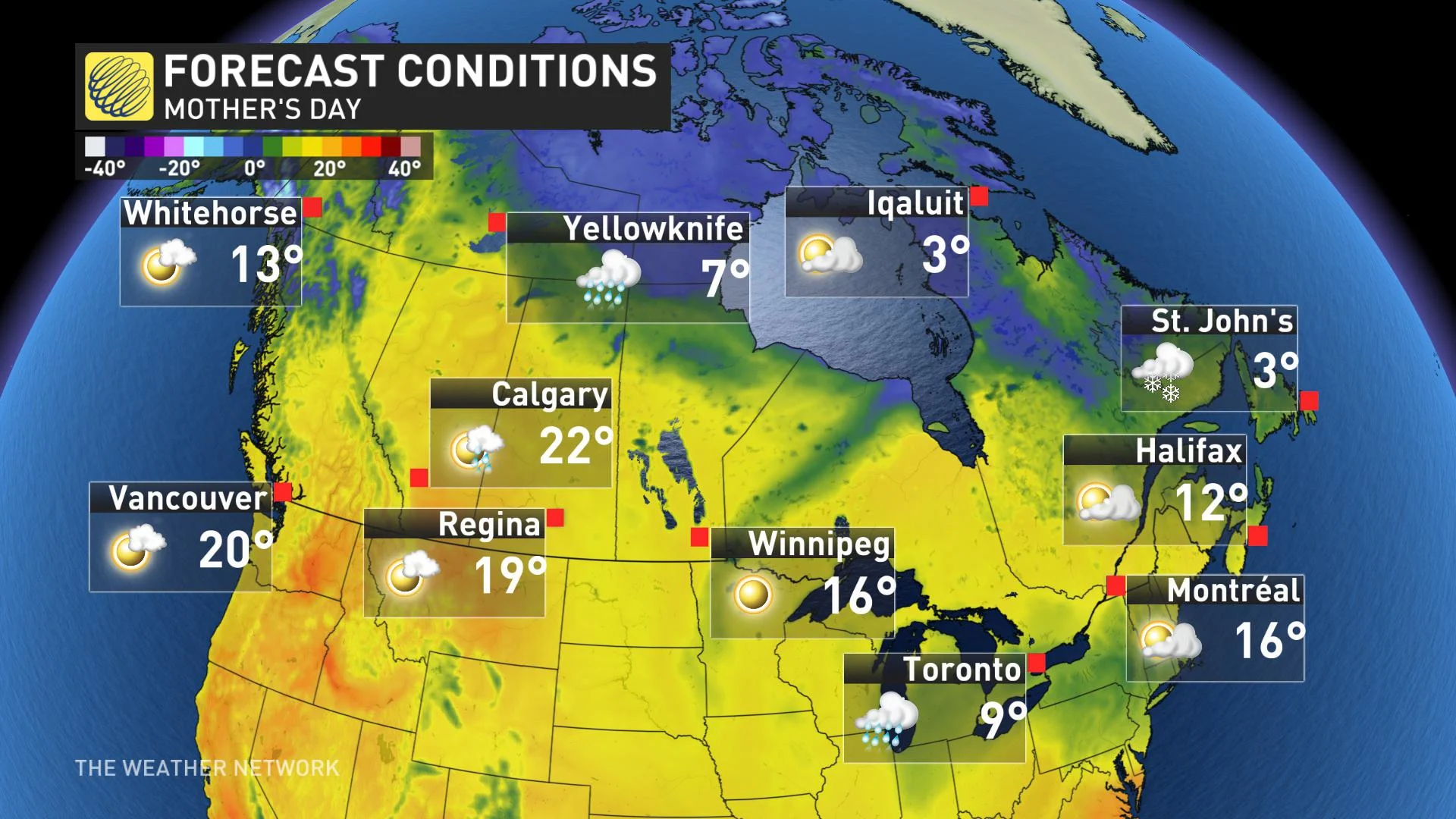
However, the eastern half of Canada will remain colder than normal through the weekend. In fact, many residents of Newfoundland will wake-up to a white Mother’s Day. Across southern Ontario, many places will remain in the single digits with an increasing threat for rain through the day with a raw east wind.
Here is a look at high temperatures across the country for Mother’s Day.
IS THERE ANY RELIEF IN SIGHT?
For next week (the week leading up to the Victoria Day long weekend), the all too familiar pattern will continue across eastern Canada. Colder than normal temperatures will dominate from the Great Lakes to Atlantic Canada. Western Canada will also transition back to a more seasonal and active pattern with rather chilly weather to the north. The map below shows a model forecast for Monday May 13 through Friday May 18th.

Near normal or colder than normal temperatures are expected across most of Canada for the start of the long weekend. So, the unofficial start to summer will feel more like April or early May.
There is some encouraging news though, for the Great Lakes and into southern Quebec. There are indications that we will see a temporary warming trend across this region during the weekend with temperatures getting back to near seasonal (or better) for the holiday on Monday. However, given how this spring has gone, I don’t blame anyone for being skeptical – our hopes for warmth have been dashed before.
Please check back for an update and more details on the Victoria Day long weekend early next week.