Beware a rising snow squall risk Sunday in southern Ontario
Drivers may find extremely tough travel conditions as snow squalls blow off Lake Huron and Georgian Bay beginning on Sunday
A stormy Saturday across southern Ontario was only a prelude to the disruptive weather expected for some areas beginning on Sunday.
Robust snow squalls are likely to develop off both Lake Huron and Georgian Bay, bringing hefty snowfall accumulations to some communities through the beginning of the new workweek.
Drivers should remain aware of rapidly changing conditions over short distances. Visibility can change from clear to a whiteout when approaching a snow squall.
DON’T MISS: Beware the dangers of fall snowstorms across Canada
Snow squalls expected to develop on Sunday
The warm air that flooded into southwestern Ontario on Saturday will be a thing of the past by Sunday after a cold front sweeps through the region.
Cold northwesterly winds blowing across the relatively warm lakes will provide the classic setup for lake-effect snow squalls to develop over communities downwind from Lake Huron and Georgian Bay.
WATCH: Wild mix of weather hits Ontario, snow squalls still to come
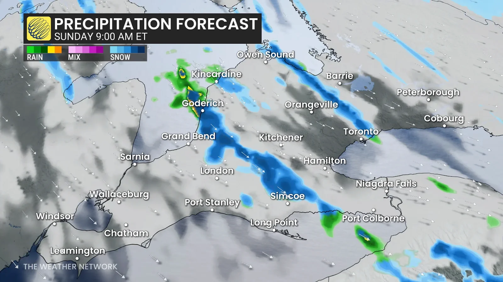
Our main snow squall off Lake Huron will target communities from London to Woodstock, with a secondary focus developing off Georgian Bay from Collingwood to Highway 400 south of Barrie.
Residents and drivers can expect snow squalls to meander over the region through the day Sunday, continuing into the overnight hours and lingering into Monday.

The band of snow off Lake Huron could produce 20-30 cm of snow for some communities in Huron, Middlesex, Elgin, Perth, and Oxford Counties. Locally higher totals are possible, especially if the band remains stationary for an extended period of time.
Communities downwind of Georgian Bay could see 5-15 cm of snow through Monday, with light accumulations pressing toward the northern Greater Toronto Area (including Newmarket and King City).
Winds will pose another hazard for drivers on top of the snow threat. Gusts could reach 60-80 km/h during the day, especially atop the escarpment and along the Lake Huron shores. This will make driving difficult, and the stiff gusts could further reduce visibility during periods of snowfall.
Header image created using graphics and imagery from Canva.
Stay with The Weather Network for all the latest on conditions across southern Ontario.